General Information | |
| Region: Off the west coast of northern Sumatra | |
| Date: 03/28/2005 | |
| Time: 16:09:36 (GMT) | |
| Time: 23:09:36 (Local time at epicenter) | |
| Magnitude: Mw 8.6 (HRV) | |
| Latitude: 2.08N | |
| Longitude: 97.01E | |
| Depth: shallow, 30 km | |
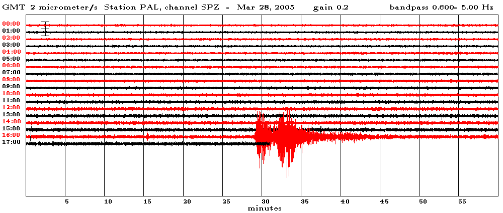
Seismograms recorded by LCSN Station PAL (Palisades, NY) |
|
 |
Vertical-component, short-period seismic records at PAL (Palisades; distance=15,000 km) in Rockland County, NY
(about 15 miles North of Manhattan) from the 03/28/2005 earthquake (Mw 8.6)
is compared with the same component from the 26 December 2004 earthquake (Mw 9.3).
PAL is about 136.3 degree from the epicenter, and hence the first arrival P wave is
the core phase, PKP(df) that traveled through the Earth's inner core followed by PKiKP
phase. Hence, the first three minutes long signals are seismic core phases
from the source (large earthquake produces long duration of source pulse), followed
by seismic phase called PP (which is P wave reflected underside of the earth surface
before reaching to the station at PAL). The PP waves on this record is slightly
longer than three minutes durtion. Hence, the source rupture duration is about three
minutes. In case of the December 26, 2004 earthquake, the source rupture duration
is about 7 minutes, and so these two waves are not separated on the seismogram shown.
Map & Source Mechanism
 |
Epicenters of the December 26, 2004, northern Sumatra earthquake and its large
aftershocks are plotted as stars.
The Harvard CMT (Centroid Moment Tensor) solutions are plotted as beach-balls
which indicate mode of earthquake faulting. The mainshock is predominantly
thrust faulting (= reverse-faulting) along fault plane dipping to the northeast.
Epicenters of the 45 large aftershocks during Dec. 26-29 and determined by NEIC (National
Earthquake Information Center/US Geological Survey, Golden, Colorado)
are plotted with circles.
 |
The Harvard CMT (Centroid Moment Tensor) solutions of major earthquakes (Mw > 7) that occurred around the December 26, 2004 Northern Sumatra earthquake epicenter are plotted as beach-balls. There were 9 shallow major earthquakes (Mw > 7) during 1976-2005.
Additional links