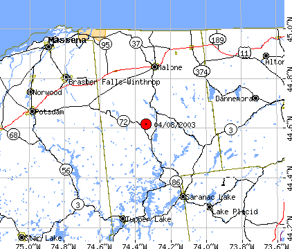
Adirondacks, Near Saranac Lake, NY


General Information

Region: 26 km S of Malone, NY; 36 km NW of Saranac Lake, NY
Date: 04/08/2003
Time: 15:06:14.4 (UTC)
Magnitude: ML = 3.2, Mc = 3.4
Latitude: 44.615 N
Longitude: 74.340 W
Depth: 10 km, fixed


Lation Map


Seismic Record Section, broadband vertical-component


This is filtered, vertical-component seismograms (0.6 - 10 Hz) plotted in epicentral distance versus time from the earthquake on April 8, 2003 near Saranac Lake, NY. This type of plot is called "seismic record section" and it is useful to look at the seismic waves propagating from the source to stations across wide area. The first arrival P waves, either Pg (dotted line) or Pn (solid line) arrival times are marked across distance up to about 500 km from the source. The slow but more strong S waves, either Sg or Sn, arrivals are marked. Actually, the strongest amplitude waves are called Lg waves and are consist of many Sg type arrivals.
Seismic records are from stations in Canada (MNT; Montreal; OTT, Ottawa; GAC, Glen Almond; KGNO, Kingston, Ontario; SADO, Sadowa, ONT; courtesy Geological Survey of Canada), US National Network Stations (LBNH, Lisbon, NH; BINY, Binghamton, NY), IRIS/USGS Global Seismographic Network (HRV, Harvard, MA), and LCSN (ACCN, Adirondack community college, NY; PAL, Palisades, NY). Stations of the USNSN and LCSN are backbone of the Advanced National Seismic System (ANSS) to monitor earthquakes and evaluate their hazards, and to mitigate their effects on our bridges, buildings, and homes.

LCSN Earthquake Alert message
Arrival time picks
Magnitude, Richter scale


Compiled by Won-Young Kim, Lamont-Doherty Earth Observatory of Columbia University