
Following the mainshock, scientists and staff at the Lamont-Doherty
Earth Observatory (LDEO) immediately went to the epicentral region with six
digital portable seismographs to monitor aftershocks. The first
station was installed about 1/2 day after the mainshock. Six more
stations were installed the next day (see the table below).
By April 27, 2002, a week after the mainshock on April 20, 2002,
16 seismographic stations
were deployed and monitoring the aftershocks in the region.
This collaborative effort is lead by LDEO with instrument and personnel
contributions from the Instrumental Software
Technologies, Inc. (ISTI; New Paltz, NY), Center for Earthquake Research and
Information (CERI), University of Memphis, PASSCAL facility of
the Incorporated Research Institutions for Seismology (IRIS) through
the PASSCAL Instrument Center at New Mexico Tech,
and the Polaris Consortium, Canada.
We achieved an important milestone in monitoring earthquakes and
evaluating their hazards through rapid cross-border (Canada-US)
and cross-regional (Central US-NorthEastern US; SouthWest-NorthEastern US)
collaborative efforts. Hence, ISTI staff -- Paul Friberg & Sid Helman,
who live in Upstate New York joined LDEO staff and deployed the first portable
station in the epicentral area; CERI dispatched two of their techinical
staff to the epicenral area with four accelerometers and a broadband
seismograph; the IRIS/PASSCAL facility shipped three digital seismographs
and ancilliary equipment within one day of the request;
the POLARIS Consortium, Canada sent a field crew of three with a near
real-time, satellite telemetry based earthquake monitoring
system. The Polaris station, KSVO (see Figure 2), powered by a solar
panel and batteries, was already transmitting data to the
central Hub in London, Ontario, Canada within a day after the field
crew arrived in the Au Sable Forks area.
This collaboration allowed us to maximize the scarce
resources available for monitoring this damaging earthquake
and its aftershocks in the Northeastern U.S.
|
|
Figure 1. Earthquakes that occurred in New York and adjacent states
during 1970-2001 (from PDE and LCSN catalog).
Earthquakes are plotted with circles and the seismographic stations
are plotted with triangles.
Au Sable Forks earthquake on April 20, 2002 is plotted with a star
and its source mechanism is indicated by a beach-ball
(thrust faulting on 45 degree dipping fault plane at a depth of 11 km).
Other major earthquakes in the past are indicated;
09/05/1944 Conwall-Massena earthquake (mb=5.8),
10/07/1983 Newcomb earthquake (mb=5.1),
01/16/1994 Reading, Pa earthquake (mb=4.6),
and 06/09/1975 Altona, NY earthquake (m=4.0).
|
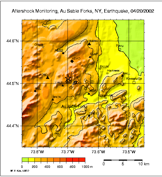
Figure 2. Location of the local portable seismograph network stations:
small solid triangles = short-period seismometers,
large solid triangles = broadband seismometers,
inverted triangles = accelerometers, and diamond = real-time
satellite telemtry station, KSVO. Mainshock and large
aftershocks located by using
regional network data are plotted with (stars). 19 small aftershocks
that occurred during April 22-27 and located by using local portable
seismographs are plotted with open circles. Towns around the
epicentral area are indicated by squares, e.g., Keeseville and Au Sable Forks. Topographic contour lines for 100, 200 and 300 meters are plotted with
dotted lines.
| STATION CODE | LAT (°N) | LONG (°W) |
ELEV (m) |
DATALOGGER (Make & S/N) |
SENSOR | OPERATION (mo/da hh:mm) |
AFFILIATION | SERVICE |
| FORD | 44.513 | 73.766 | 365 | Guralp DM24 | CMG-40T | 04/21 02:27-04/30 17:32 | ISTI | - |
| JEEP | 44.475 | 73.631 | 144 | Reftek 262 | L22 | 04/21 14:06 | LDEO | - |
| SCAP | 44.562 | 73.627 | 333 | Reftek 526 | L22 | 04/21 17:07 | LDEO | - |
| LAKE | 44.495 | 73.716 | 354 | Reftek 524 | L28 | 04/21 20:45 | LDEO | - |
| MESS | 44.571 | 73.715 | 283 | Reftek 232 | L22 | 04/21 23:16 | LDEO | - |
| BARN | 44.593 | 73.629 | 256 | Reftek 240 | L28 | 04/22 00:44 | LDEO | - |
| BARN | Guralp DM24 | CMG-40T | 04/25 20:00 | CERI | CD failed | |||
| BILL | 44.482 | 73.806 | 408 | Reftek 6115 w/disk | L22 | 04/23 21:52 | ISTI/LDEO | - |
| BILL | K2/1365 | L28 | 04/25 20:30 | CERI | STA/LTA=6 | |||
| SKUN | 44.535 | 73.594 | 180 | K2/1368/solar | L28 | 04/25 14:10 | CERI | STA/LTA=3, need battery |
| GREE | 44.425 | 73.629 | 238 | Reftek 479 | L22 | 04/25 12:50 | PASSCAL | - |
| GREE | K2/1361 | L28 | 04/25 16:45 | CERI | STA/LTA=4 | |||
| OREB | 44.586 | 73.781 | 280 | K2/1362/solar | L4C/2 Hz | 04/26 19:00 | CERI | STA/LTA=6 |
| BROK | 44.462 | 73.749 | 300 | Reftek 525 | L22 | 04/25 14:00 | PASSCAL/LDEO | DAS 393 failed 05/10 |
| KSVO | 44.552 | 73.686 | 381 | Trident | CMG-3ESP | 04/26 18:04 | POLARIS | - |
| HALL | 44.519 | 73.521 | 210 | Reftek 117 | L22 | 04/27 14:30 | PASSCAL | noisy site 05/10 |
K2 set with 1 g full scale, trigger on 0.1-12.5 Hz filter band set at 2% g, and
sampling at 200 samples/sec
 Station Table Station Table for Print
Between April 22 and April 27, we detected and located 19 small
aftershocks (see Figure 2). The initial mainshock hypocenter
determined from regional stations was only about 3 km NW and
within the depth range of preliminary aftershock hypocenters.
Thus, we were able to capture early aftershocks with a network
that spans a 20 km-wide area centered above a 10 km deep source.
The epicenter of the mainshock is about 8 km
north of town of Au Sable Forks, and hence the April 20, 2002
Plattsburgh, NY earthquake is now formally called Au Sable Forks
earthquake.
Additional Links