Mapping the Moho beneath Northeastern United States
Mapping the Moho underneath LCSN stations in the NE U.S. by the Reciever Function Analysis
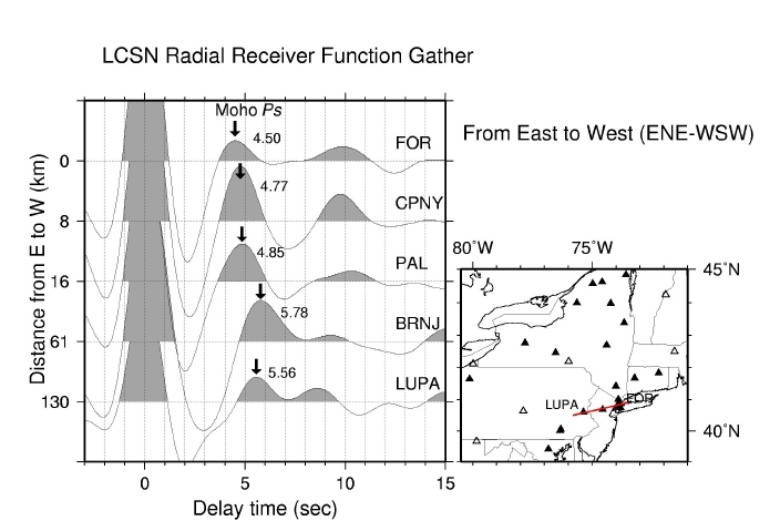
Above receiver functions (RF) are calculated by John Armbruster.
It is the radial receiver functions that show Ps phase
(P to S converted at the Moho) at five stations of LCSN along ENE to WSW
direction (azimuth ~250 degree). The RF at each station is plotted
with the positive amplitude shaded to help clear display of
the Ps phase and other converted phases. P wave arrival is at time zero (0)
and Ps phase arrival is marked by an arrow and its time is indicated
next to the phase arrival.
The vertical axis show distance from a reference point, in this case,
Fordham (FOR) in the Bronx, NYC, to each station along WSW direction.
Hence, LUPA (Lehigh) is about 130 km from the FOR.
This preliminary receiver function analysis of several stations along New York City
to Lehigh Valley in Pennsylvania suggest that Moho depth is about 34 km beneath the Bronx,
Manhattan, and Palisades, and it gradually increases to about 42 km
beneath Basking Ridge, NJ and Lehigh, Pennsylvania going westward.
Here we used a simple rule to estimate the Moho depth from the receiver
function, as; (Ps time - P time) x 8 km/s = 4.50 s x 8 = 36 km.
See the ray paths for P and Ps phase from the diagram below.
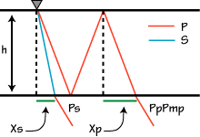
A diagram borrowed from Prof. Charles J. Ammon at Penn State. See his
excellent description on the receiver function.
Chuck Ammon's RF page
Chuck Ammon's RF browser
For LUPA, it is ~5.5 s x 8 km/s = 44 km. I think that may be I used 7.6 km/s
instead of 8 km/s for the abstract. This show a range of uncertainty, simply
due to using certain average P- and S-wave speed in the crust.
This suggests an ~8 km increase of the Moho depth along 130 km distance
from the east to the west (from the Bronx to Lehigh), which corresponds
to ~3.5 degree slope for a flat Moho. Back-azimuth gathers of receiver
functions at Basking Ridge, NJ suggest that the Moho might locally dip
to the southeast by as much as 20 degrees. The Ps phase, P to S
converted phase at the Moho, samples very close to the station (~6 to
10 km), and is the most prominent phase sampling the lateral
structure. Since the LCSN broadband stations cover a region with a
diverse geological environment - Newark basin, Appalachian, Adirondacks
and Avalonian from the south to the north, we expect that the receiver
function analysis will provide very interesting results.
Sept. 2006, Won-Young Kim
Return to LCSN ES-SSA 2006
Won-Young Kim, Lamont-Doherty Earth Observatory of
Columbia University, copyright©2006, all rights reserved