
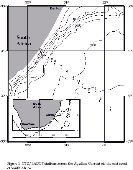
The Agulhas Current is the Western Boundary Current of the southwest Indian Ocean. In March 1995, as part of the Agulhas Current Experiment (ACE), a section of fifteen full depth CTD/LADCP stations and shipboard ADCP data was collected across the current at 32S (figure 1). The LADCP measurements revealed an Undercurrent not observed before flowing equatorward beneath the core of the poleward flowing Agulhas Current. These observations prompted a closer investigation into comparisons between LADCP, shipboard ADCP and geostrophic estimates of the velocity field.
2 Estimating the measurement errors in geostrophic velocity
The dynamic method consists of
vertically integrating the geostrophic approximation as expressed
in pressure co-ordinates and is usually evaluated by first differences:
![]() 1
1
where = 1/ is the specific volume,
/x is taken along constant pressure surfaces, = - (35,0,p)
is the specific volume anomaly relative to a ìstandard
oceanî specific volume and ![]() is the difference
in dynamic height anomaly between, for instance, stations 1 and
2 separated by distance L. Thus, the error in the geostrophic
velocity can be estimated assuming that the three sources of error
are uncorrelated (Johns et al, 1989):
is the difference
in dynamic height anomaly between, for instance, stations 1 and
2 separated by distance L. Thus, the error in the geostrophic
velocity can be estimated assuming that the three sources of error
are uncorrelated (Johns et al, 1989):
 2
2
1 2 3
So the measurement errors in geostrophic
velocity arise from uncertainties in the station spacing
(2), the dynamic height measurements (1) and the reference
velocity (3). The error in dynamic height anomaly, based on
the measurement error in temperature and salinity, is at most
0.004dyn m. While a previous study in the Gulf Stream indicates
that by far the most important source of error is the station
spacing term, which contributes errors as large as 12cms-1
when ship drift is assumed random (Johns et al, 1989),
in assessing these errors for the Agulhas Current, it was found
that most station pairs exhibited an on-station drift of similar
magnitude and direction so that the drift ultimately makes little
contribution to station spacing error.
Overall, the maximum baroclinic
geostrophic velocity error across the Agulhas Current (terms
1 and 2 of equation 2) is less than 0.6cms-1,
except at station pair 11-10 where the error is as much as 3cms-1.
Thus the error associated with the approximation or measurement
of a reference velocity will generally be the largest component
of the measurement error in absolute geostrophic velocity.
Another important source of error is sampling biases which can result if the Agulhas Current shifted laterally during the seven day occupation of the ACE section. The resultant fractional error in the measured isopycnal slopes is equal to the ratio of the lateral velocity of the current path to the shipís velocity along the transect. Estimating the maximum meander lateral velocity to be 6kmday-1 on the ACE section and taking the extreme case of stations 9 and 8, which have a station spacing of just 10km and were sampled 13 hours apart, then a maximum error of 30% could potentially arise in the geostrophic velocity.
The LADCP velocities have an accumulative error that derives from the stringing together of each shear profile over the depth of the cast (Firing and Gordon, 1990). Consider a bad velocity measurement occurring in a bin at the centre of a profile, with bins above and below it. This bad point produces a peak in the shear profile - in other words the shear is negatively correlated to either side of it. Now consider a bad velocity occurring in the last bin of a profile. In this instance the shear becomes offset and does not recover because there is no good data following the bad to produce a sharp gradient in the opposite sense. This error then, translates to low vertical wavenumbers, producing an offset which will affect the remaining shear data as it is added on. Assuming no instrument bias this error can be estimated by a random walk:
On average the SD of the velocity
from each ping of the LADCP was 2.3x10⁻³ cms-1
(dependent on the set-up of the instrument). During ACE the ping
rate = 1 s-1 and the lowering rate of the instrument
was approximately 1 ms-1. The profiling range of the
instrument varies with depth mainly as a result of the variability
of scatterers in the water column. Taking a conservative average
of 96 m (5 x 16 m bins plus a 16 m blank-after-transmit), then
the number of pings per profile averages 96 and the standard deviation
per profile is thus 0.24 cm s-1. This error then accumulates
to low vertical wavenumber motions, as the shear profiles are
strung together over the depth of the cast, so that,  for
a cast of 2500 m depth (i.e. n = 26 profiles). This
estimate of the errors is overly optimistic however, since it
ignores bias, increase in SD with range, swimmers and the sampling
of high frequencies. In practice LADCP errors at low vertical
wavenumbers have been found to be up to an order of magnitude
greater than this calculated SD (Firing and Gordon, 1990).
for
a cast of 2500 m depth (i.e. n = 26 profiles). This
estimate of the errors is overly optimistic however, since it
ignores bias, increase in SD with range, swimmers and the sampling
of high frequencies. In practice LADCP errors at low vertical
wavenumbers have been found to be up to an order of magnitude
greater than this calculated SD (Firing and Gordon, 1990).
4 Comparing LADCP and shipboard ADCP
The time-averaged on station ADCP
profiles are compared with LADCP velocities over the top 300m
of the water column (figure 2). The
standard deviations of the depth-averaged differences between
LADCP and ADCP absolute velocities are summarised in the table
below.
| station | 11 | 10 | 9 | 8 | 7 | 6 | 5 | 14 | 4 | 3 | 15 | 2 |
| cross-track | -1.4 | 5.7 | 1.3 | -2.6 | 3.5 | 2.6 | 0.4 | 3.4 | 4.0 | 3.6 | 2.3 | -2.7 |
| st.deviation | 1.5 | 0.9 | 1.5 | 1.0 | 2.2 | 2.0 | 3.1 | 1.9 | 1.7 | 1.9 | 2.2 | 1.8 |
| along-track | 5.4 | 2.1 | 2.2 | 4.2 | -0.4 | 1.2 | -0.9 | 3.4 | -2.4 | 3.1 | -4.7 | -0.2 |
| st.deviation | 1.8 | 1.3 | 2.9 | 0.9 | 2.5 | 2.0 | 2.2 | 1.2 | 1.4 | 2.1 | 2.6 | 1.6 |
Table 1 The depth-averaged difference
between LADCP and ADCP on station, cross-track and along-track
velocity profiles in cms-1, plus the standard deviation
of the difference.
The two independent measurements of cross-track velocity exhibit similar shear structure on all stations and with the exception of station 10, the cross-track depth-integrated difference between the two techniques is 4cms-1 or less. There is no indication that the LADCP consistently under-estimates or over-estimates near-surface ocean currents. These results indicate that LADCP and shipboard ADCP are essentially showing the same pattern of ocean currents over the top 300m of the water column.
5 Comparing geostrophic and LADCP velocities
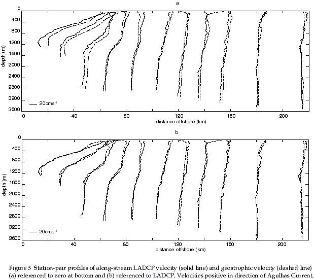
In order to make direct comparisons
between the two methods, the LADCP measurements were linearly
interpolated onto station pairs. The two sets of velocity profiles
are in good agreement except close to the surface where the shears
are sometimes dissimilar (figure 3).
The geostrophic velocities have been referenced to the LADCP measurements
by estimating the depth-integrated (barotropic) difference between
the profiles from each method and adjusting them so that this
difference is zero. The top 200m of the profiles were not included
in the calculation since here the direct and geostrophic shears
are not well correlated. The matched profiles are shown in figure
3 and the standard deviation of the fit and the resultant
geostrophic bottom velocities are given in the table below.
| station pair | standard deviation (cms-1) |
bottom velocity (cms-1) |
| 11-10 | 8.9 | -21.7 |
| 10-9 | 6.6 | -16.4 |
| 9-8 | 7.1 | -11.5 |
| 8-7 | 4.2 | 1.5 |
| 7-6 | 5.4 | 6.6 |
| 6-5 | 2.9 | -2.0 |
| 5-14 | 5.3 | -1.2 |
| 14-4 | 4.1 | -4.3 |
| 4-3 | 2.7 | -6.0 |
| 3-15 | 4.5 | -1.0 |
| 15-2 | 3.2 | 1.2 |
Table 2 The standard deviation
about the depth-mean difference (below 200m) between profiles
of LADCP and geostrophic velocity on each station pair and geostrophic
bottom velocities, given in cms-1 for each station
pair. Positive velocity indicates flow in the direction of the
Agulhas Current.
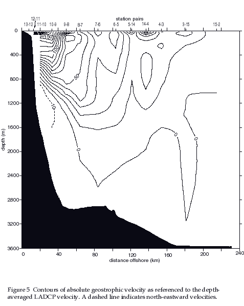
The absolute geostrophic velocity
as referenced to LADCP reveals north-eastward flow at depth, consistent
with Undercurrent observations from LADCP and from moored current
meter data - see figures 4 and 5.
The volume transport of the Agulhas Current from absolute geostrophic velocities is 73Sv (including bottom triangle adjustments) as compared to 75Sv from LADCP velocities alone.
6 Comparing geostrophic and shipboard ADCP velocities
On station time-averaged ADCP profiles were interpolated onto station pairs in the same manner as the LADCP profiles. Geostrophic and ADCP velocity profiles at four station pairs are shown in figure 6. The shears of the two sets of velocities are not well matched over the limited depth range of the ADCP. As a result when the geostrophic velocities are referenced to shipboard ADCP using the same method as described for the LADCP,the standard deviation of the fit is as high as 20 cms-1. Further, the deep velocity field is unrealistic, with bottom velocities as large as 14cms-1 180km from the coast and at adjacent station pairs 7-6 and 6-5 the bottom velocity switches from 7cms-1 northward to 16cms-1 southward. In conclusion we have been unable to use shipboard ADCP to obtain a geostrophic reference velocity which produces a consistent and reliable estimate of the absolute geostrophic velocities.
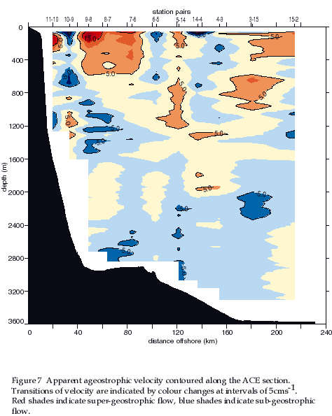
Figure 7 shows contours of ![]() ,
the difference between the direct LADCP measurements and matched
geostrophic velocities. Below 300m v is generally within
the measurement errors estimated above and therefore is not significant.
The highest magnitudes of v occur in the upper 300m in
the core of the Agulhas Current.
,
the difference between the direct LADCP measurements and matched
geostrophic velocities. Below 300m v is generally within
the measurement errors estimated above and therefore is not significant.
The highest magnitudes of v occur in the upper 300m in
the core of the Agulhas Current.
There are a number of phenomena
that may explain geostrophic departures that cannot be accounted
for through error considerations. Since the LADCP measures instantaneous
currents, tidal velocities must contribute to the differences
between observed and geostrophic velocities. However, from a tidal
analysis of the moored current meter data, barotropic tidal
velocities across the Agulhas Current were found to peak at just
1.5cms-1 and therefore will have a negligible effect
when compared to the magnitude of the measurement errors estimated
above.
The near-surface geostrophic departures
could be the result of non linear flows. The LADCP observations
allow direct estimates of uu/x, the advective acceleration.
In the surface core of the current (between stations 11 and 10)
exists the largest gradient in the cross stream flow, about 10cms-1
over 5km, which results in uu/x values of approximately
2% of fv.
Another way to estimate the non
linear departure from geostrophy is to estimate the path curvature
of the Agulhas Current. For instance, taking the gradient velocity,
vgrad to include the centripetal term due to
the curvature of the Agulhas Current then,
![]() . 3
. 3
From examination of a chart, the radius of curvature of the continental shelf from Durban (30S) to Port Edward (31S) is estimated to be 400km. Assuming that the Agulhas Current follows the topography and taking vg as 150cms-1 in the surface core of the current then vgrad will be 8cms-1 greater than the geostrophic velocity here. The general pattern of geostrophic departures due to vgrad would be a swath of positive values across the Agulhas Current with a maximum in the current core and values reducing away from the coast and with depth, consistent with the velocity field of the WBC. This pattern of super-geostrophic flow is not consistent with the pattern of geostrophic departures seen in figure 7 which are patchy, sometimes negative and do not appear to increase as the geostrophic velocity increases. This implies that there must be additional factors causing geostrophic departures near the surface.
Potential vorticity (PV) can be calculated effectively from LADCP and CTD data since the measurements coincide in time and space. PV can be expressed in a natural co-ordinate system that reflects the geometry of the Agulhas Current. Using Ertel vorticity (Pedlosky, 1986) and neglecting unimportant terms it can be written:
![]() 4
4
where x is the cross stream co-ordinate (positive offshore) and z is depth (positive upwards). The first term on the right hand side is the planetary vorticity multiplied by the stratification, the second term is the shear vorticity (including stratification) along an isopycnal. Since the density surfaces in a WBC are not horizontal, the shear vorticity normal to an isopycnal has contributions from both the vertical and horizontal shear of the current. The vertical density gradient can be expressed in terms of the buoyancy frequency, N and the horizontal density gradient can be expressed in terms of the vertical shear using the thermal wind balance:
![]() 5
5 ![]() 6
6
So that the potential vorticity equation becomes:
 7
7
These three components of Q
are shown in
figure 8 and the
total PV is shown in
figure 9. At depths
between 400m and 1400m and within about 80km of the coast the
lateral gradient of total PV is high and the its magnitude becomes
large. The transition between relatively uniform PV in the eastern
end of the section and the inshore region of large lateral PV
gradients is located just to the west of the Agulhas Current core
and moves offshore with depth, as does the current core. This
transition occurs at a PV value of about 1.310-10m-1s-1
and between the 14C and 4C isotherms, above and below which the
PV is more or less uniform along an isotherm across the whole
section. Thus at intermediate depths there is a tendency for
the PV distribution to behave like a barrier between the high
velocity cyclonic core of the Agulhas Current and water farther
offshore, impeding lateral mixing of intermediate water masses.
Such a barrier may help explain why RSW and AAIW are so distinct
along the same isopycnal in the Agulhas Current. The PV barrier
in the Gulf Stream is stronger than its counterpart in the Agulhas
Current and extends almost from the sea surface to about 7C (Leaman
et al, 1989). Below 7C the PV is practically uniform across
the width of the Gulf Stream, supporting other work which has
suggested that there is a relatively free exchange of fluid across
the current in the deep layers (Bower et al, 1985). In
the Agulhas Current such a free exchange may be expected in waters
of potential temperature less than 4C.
Although the high PV gradients
appear to be coincident with the region of greatest velocity shear
on the cyclonic side of the Agulhas Current, in fact they are
primarily a result of increased stratification and not of increased
relative cyclonic vorticity (see figure 8).
At the foot of the continental slope the horizontal density gradient
increases, doubling at mid-depths, resulting in a decrease in
layer depth in the same region that the PV ëbarrierí
occurs.
Various investigators have attempted to use PV as a conservative tracer to follow types of ëmodeí waters (e.g., McDowell et al, 1982; Talley & McCartney, 1982; Talley & Raymer, 1982). The PV distribution across the Agulhas Current is shown in figure 10 using potential density as the vertical co-ordinate and with contours of salinity and oxygen overlayed. The area of high negative PV is coincident with the relatively high salinities that indicate RSW next to the continental slope and is just above the oxygen minimum. This may suggest that the mid-depth negative PV maximum is acting as a tracer of RSW, much like the salty, mid-depth Mediterranean water outflow in the North Atlantic can be seen as a relative PV maximum.