|
11. Increased winter precipitation projections for California under climate change are likely overestimated
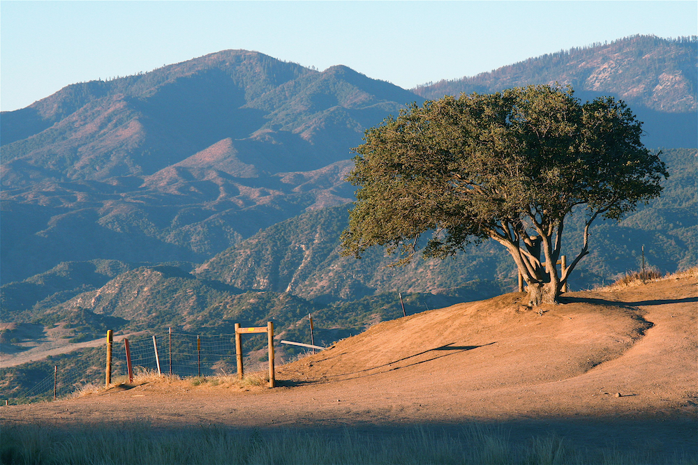
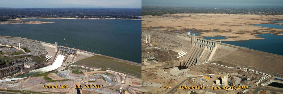
During the fourth year of the California drought (see here) it might be hard to realize that current climate models rather robustly project that rising greenhouse gases will cause California from LA north to get wetter, not drier, in midwinter. The models do however predict a spring drying so, in effect, a shorter, sharper wet season. To some extent this mid-winter wet shift for California and the west coast is simple thermodynamics. In winter this is a wet region after all and as humidity rises in a warmer atmosphere it is expected to get wetter according to the famous "wet get wetter, dry get drier" argument for hydroclimate change. In the case of the west coast the mean winds that impinge on the mountains and the storm systems coming from the Pacific will simply be carrying more moisture and providing more precipitation. Of course as the air warms more of that will fall as rain and less as snow which will cause problems for water resource systems that rely on winter storage of water on mountains in the form of snow followed by spring runoff.
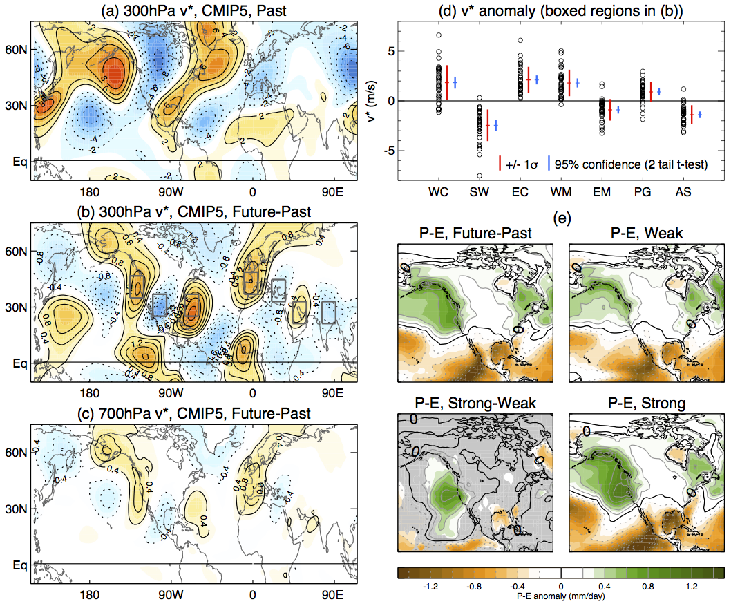
However it is not that simple. In Seager et al. (2014, J. Climate) we performed a complete moisture budget breakdown of the CMIP5 climate models and show that on top of this thermodynamic effect, the west coast wets in winter due to a shift to more southwesterly mean winds. The wetting southwesterlies are part of a wave train that also brings drying northerlies to the interior southwest and wetting southerlies to the U.S. east coast. This wave train extends across the Pacific and North America, appearing to originate from Asia, and is quite robust across the CMIP5 models. In a new paper (Simpson et al. Nature Climate Change) we examine the cause of the anomalous wave train and argue that models are likely overestimating it. Through consideration of the processes involved, it is argued that there are good reasons to consider the majority of models, and consequently the multi-model means and medians to be biased wet in their future hydroclimate projections for California. As such, future winter wetting of California is likely to be on the dry end of the model predicted range. The new research uses a modeling strategy whereby the climatological mean wave field in the model, and its change in response to rising GHGs, are first reproduced in an idealized and simplified model. The simple model is then used as a laboratory where controlled experiments can be performed to identify causality in the wave response. Waves in the atmosphere can be forced by surface features like mountains or by heating of the atmosphere by condensation of water vapor, radiation and surface fluxes of heat. Once forced, the wave field - the location and strength of the high and low pressure features that make up the wave - depends on the flow field through which it propagates. It was found that the GHG-induced change in the zonal mean zonal wind was the cause of the change in the wave field that brought the southerly-northerly-southerly change in wind direction across North America from west coast to east coast. The zonal mean zonal wind change itself has many features such as weaker sub polar westerlies due to strong Arctic warming, easterly wind changes in the subpolar stratosphere and subtropical westerly jet acceleration and poleward shift of the lower tropospheric westerlies. Of these, further experiments found that it was the subtropical westerly jet acceleration that almost entirely accounted for the change in the wave field.
Figure 1: Changes in meridional wind and precipitation minus surface evaporation (evapotranspiration over land) (P-E) for December to February of 2070-99 minus 1979-2005. The left column shows, from top to bottom, the 1979-2005 climatological upper troposphere meridional wind, its future minus past change, and the change within the lower troposphere. The upper right shows regional changes in meridional wind for all the models and makes clear this is a quite robust change. The lower right four panels shows the changes in P-E: to left is the CMIP5 multimodel mean. The top right is the same but for a subset of models that have realistic climatological amplitude of the wave field whose change is important for west coast wetting. Bottom right is the same but for the subset of models that have an overly high amplitude wave field. Bottom left if the strong minus weak difference. The amplitude of this wave field, which is proportional to the strength of its change in response to rising GHGs, has a large influence on west coast P-E change. The results suggest reality will be more like the weak composite than the all model mean or the strong composite. i.e. a weaker west coast wetting. Essentially, as the subtropical upper troposphere westerlies accelerate the waves forced by heating and orography become larger scale in the east-west direction. As the waves lengthen it causes changes in the direction and strength of the prevailing winds. Southerly changes at the west coast are one such change. It is not surprising that this wave change is robust across the various models. Since it depends on the subtropical westerly acceleration, all the models do it because the latter is to a large extent a simple consequence of upper tropospheric tropical warming which itself follows from deep convection communicating surface warming throughout the troposphere. That the change in wave field depends on such a simple well understood and physically reasonable change in the tropospheric winds and temperature, means that we can place considerable confidence in its reality. However the new research also shows that the CMIP5 models tend to overestimate the amplitude of the forced waves that are of relevance to the west coast wetting. Further, the stronger the wave in a model the stronger the change in response to rising GHGs. If you look at the models that tend to have a more realistic amplitude of the relevant climatological wave, then the change in the wave field is also on the small side. Because of this it seems clear that the wetting of the west coast from LA northward that will occur in reality is probably on the weak end of what the models project. Let's be clear, even accounting for this bias, the models suggest mid-winter precipitation should increase at the west coast in the future. But these new results indicate it will probably do so by less than the mean or the median or what the majority of models suggest. Mid-winter wetting, being accompanied as it is by spring drying, less snow and more rain and rising temperatures driving more evapotranspiration, was never going to mean that California's water future was going to look good but these new results mean that it probably now even looks a bit worse.
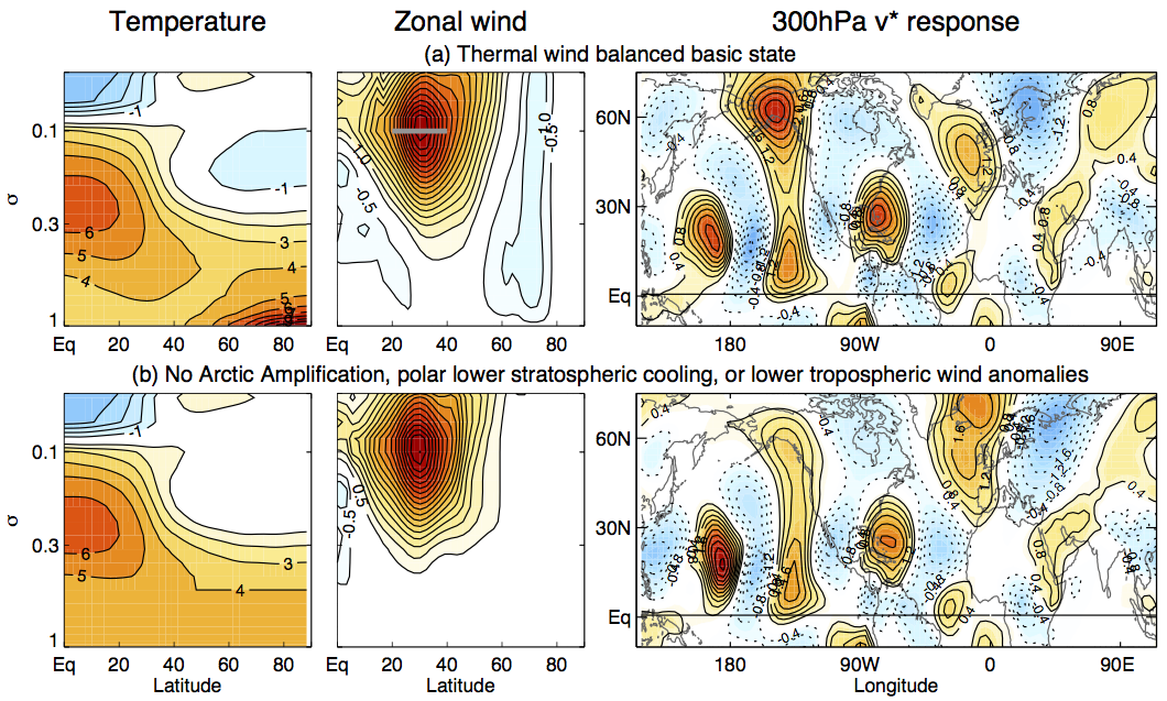
Figure 2: Results from the idealized modeling. The top panel shows the change in zonal mean temperature and wind from the CMIP5 multimodel ensemble mean and the change in the wave field (represented by the 300mb meridional wind field) that this causes (in the presence of unchanged heating etc.). The lower panel shows the same but for the case where the subtropical jet wind changes have been isolated so that the wave field is only responding to those. Note that the waves tilt westward with height so that the southerly anomalies off the west coast in the upper troposphere shown here correspond to southerly anomalies at the coast in the lower troposphere. |
 EASM2: LINKING NEAR-TERM FUTURE CHANGES IN WEATHER AND HYDROCLIMATE IN WESTERN NORTH AMERICA TO ADAPTATION FOR ECOSYSTEM AND WATER MANAGEMENT EASM2: LINKING NEAR-TERM FUTURE CHANGES IN WEATHER AND HYDROCLIMATE IN WESTERN NORTH AMERICA TO ADAPTATION FOR ECOSYSTEM AND WATER MANAGEMENT | |
| Lamont-Doherty Earth Observatory of Columbia University 61 Route 9W Palisades, NY 10964
| |
|
| |