|
Southeast Asian Archipelago: Indonesian and Philippine Seas Arnold L. Gordon The Exotic Seas of Southeast Asia The ocean, unlike the globally enveloping atmosphere is segmented into seas, interconnected with passages of varied dimensions. Each ocean differs somewhat in its overall temperature and salinity, which owing to the great heat capacity of seawater and its central role in the hydrological cycle exerts a strong influence on climate. The Pacific is relatively cool, fresh and well stratified, while the Atlantic is warm, salty and prone to deep reaching overturning circulation in the northern North Atlantic, which among other consequences leads to a rather warm amiable climate in northern Europe.
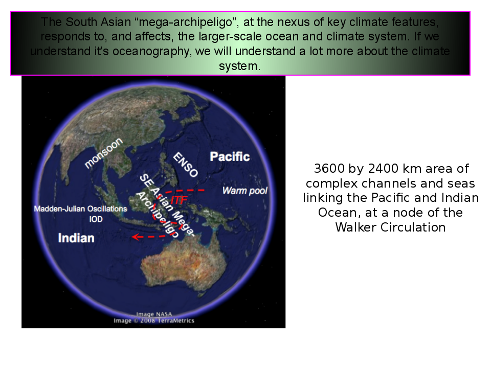
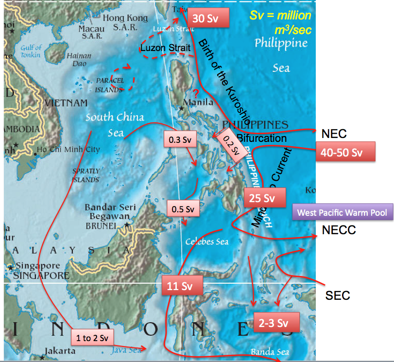
A truly unique part of the ocean's geography is the seas of southeast Asia, with such exotic names as the Java Sea, the Sulu Sea and the South China Sea. What makes these seas so fascinating to the oceanographer is their archipelago arrangement, stretching some 2800 miles from Australia to southeast Asia. The multitude of Islands of the Philippines and Indonesia constrain the ocean into a configuration of narrow passages and seas, of varied sizes and depths. Archipelago arrangement represents a challenge to our understanding of ocean processes, as needed to properly simulate ocean and climate models. Yet we need to get it right, as through these southeast Asian seas tropical Pacific water weaves its way into the Indian Ocean, in what is referred to as the Indonesian Throughflow (ITF), affecting the characteristics of such well known climate phenomena as El Niño and the Asian monsoon. Lamont oceanographers are involved in many field studies of the Indonesian and Philippine Seas: 1. the "International Nusantara Stratification and Transport" (INSTANT) program in the Indonesian Seas; 2. on-going monitoring of the Makassar Strait throughflow, the primary conduit of the ITF; 3. Study of the throughflow from the South China Sea to the Java Sea via the Karimata Strait; and 4. the "Characterization and Modeling of Archipelago Strait Dynamics" (PhilEx) program in the Philippine Seas.
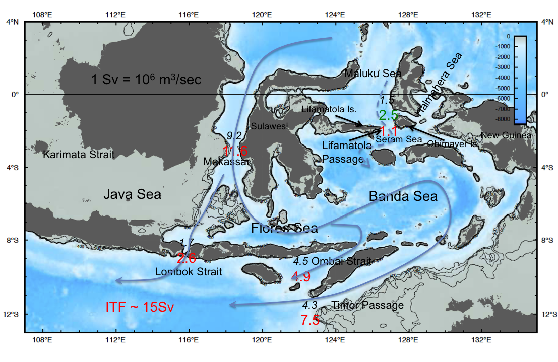
The Indonesian Seas: INSTANT Professor Arnold L. Gordon and Dr. Dwi Susanto completed in November 2006, with colleagues in the U.S. as well as in The Netherlands, France, Australia and Indonesia a landmark program to simultaneously measure the transfer of water and heat from the Pacific Ocean to the Indian Ocean through the Indonesian Seas, the ITF, over a three year period, 2004 through 2006 in all of the major passages. The component of the INSTANT program covered by Lamont researchers is the Makassar Strait, the major pathway for Pacific water entering into the Indonesian Seas.
The Indonesian Seas provide a sea link between the tropical Pacific and Indian Oceans. The connection is not simple, not a single gap in a 'wall' but rather composed of an intricate pattern of passages and seas of varied dimensions. The velocity and temperature/salinity profiles of the ITF are altered en route from the Pacific into the Indian Ocean by sea-air buoyancy and momentum fluxes, as well as diapycnal mixing due to topographic boundary effects and dissipation of tidal energy. The INSTANT program measured the ITF in key channels from 2004 to 2006, providing the first simultaneous view of the main ITF pathways. The along-channel speeds vary markedly with each passage; the Makassar and Timor flow is relatively steady in comparison to the seasonal and intraseasonal fluctuations observed in the Lombok and Ombai Straits. The flow through the Lifamatola Passage is strongly bottom intensified, defining the overflow into the deep Indonesian basins to the south. As the ITF region is at the nexus of ENSO (El Niño/La Niña) and the Asian monsoon phenomena, it is highly likely, as indicated by model studies, that the ITF serves as a key component of the larger scale climate system. Makassar Strait Throughflow: The Makassar Strait throughflow time series, at 2°51' S; 118°28' E; 2147 m, in the Labani Channel 45 km wide constriction of Makassar Strait, began with NSF funded Arlindo program in 1996-1998, and continued with NSF funded INSTANT 2004-2006 (November) and NOAA OCO 2006 (December), with the most recent recovery in August 2011, but not re-deployed due to logistical complications. The mooring was deployed on 5 August 2013, after a two-year gap in the time series.
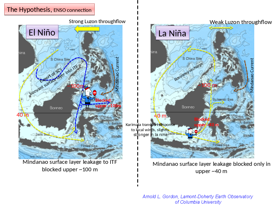
The time series of the Makassar Strait throughflow, which carries ~80% of the total ITF and ~90% of the ITF within the thermocline, has revealed some startling changes in the ITF, which may have large scale significance to the ocean and climate system, with possible improvement in long term (interannual) predictions. The time series of the Makassar Strait throughflow, which carries ~80% of the total ITF and ~90% of the ITF within the thermocline, has revealed some startling changes in the ITF, which may have large scale significance to the ocean and climate system, with possible improvement in long term (interannual) predictions. In 2008/09 the profile of the Makassar Strait throughflow changed dramatically (Gordon, A.L., Huber, B.A., Metzger, E.J., Susanto, R.D., Hurlburt, H.E., Adi, T.R. (2012) “South China Sea Throughflow Impact on the Indonesian Throughflow” Geop Res Lett: doi:10.1029/2012GL052021 vol (39) L11602): the characteristic thermocline velocity maximum increased from 0.7 to 0.9 m/sec and shifted from 140 m to 70 m, advecting much warmer water into the Indian Ocean. ENSO induced change of the South China Sea (SCS) throughflow drawn from the Luzon Strait is the likely cause. Increased westward Luzon Strait throughflow during El Niño forced buoyant SCS surface water into the northern Makassar Strait, inhibiting tropical Pacific surface water injection from the Mindanao Retroflection; during La Niña SCS throughflow is reduced to near zero, allowing increased surface water leakage from the Mindanao Retroflection. We find that commensurate with the change in the ITF profile, there is a change in the development of the Kuroshio off the east coast of Luzon. During La Niña there is greater injection of tropical Pacific water from the North Equatorial Current Bifurcation into the Kuroshio, as the Luzon Strait westward La Niña throughflow is reduced to near zero, is free to fully project into the Kuroshio recirculation cell of the western subtropical North Pacific. During El Niño the Kuroshio recirculation cell is 'isolated' from the North Equatorial Current Bifurcation. During El Niño the increased western throughflow in Luzon Strait drains the Kuroshio recirculation gyre waters, thus exporting the accumulated tropical water input during the previous La Niña phase.
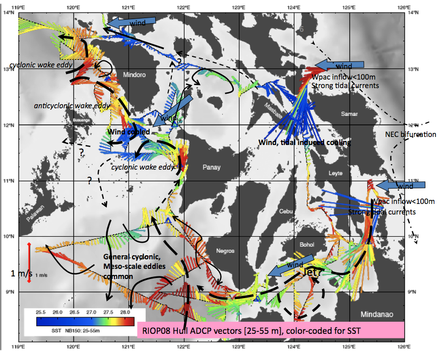
Besides the impact on the Pacific Ocean the Indian Ocean also is affected, with La Niña warmer and stronger ITF leads to warmer sea surface temperatures in the eastern tropical Indian Ocean within 2 years. This is an ‘ocean-bridge’ linking the Indian Ocean to ENSO. Warmer SST within the eastern tropical Indian Ocean can affect the strength of the Asian Monsoon and induce a negative Indian Ocean Dipole. It has been found (Wilson et al. 2013) that negative IOD can project via stronger Madden-Julian Oscillation (MJO) eastward over the Indonesian maritime continent towards the Pacific, an ‘atmosphere bridge’ of Indian to pacific climate events. Might such MJO events then trigger an El Niño, about 4 years after the La Niña induced warmer ITF? The Philipine Seas: PhilEx The complexity of the Philippine seas offer an ideal setting to further investigate the ocean physics within complex geography. Lack of information on the Philippine seas have hindered progress in understanding the connectivity of the open Pacific to the marginal seas of southeast Asia and to the roots of the Kuroshio Current. To enhance our understanding of ocean dynamics within Archipelago configurations, as required to improve our capability to predict oceanic spatial and temporal variability, a program within the Philippine region, involving in situ (ship, moorings, untethered instrumentation) and remote observational methods with global and regional model components, called PhilEx was developed, with Office of Naval Research support. PhilEx involved U.S. and Philippine research from numerous institutions. The objective of PhilEx is to enhance our understanding of the oceanographic processes and features arising in and around straits, and improve our capability to predict the spatial and temporal variability of these regions. Features and processes of interest are those which drive the local spatial variability on short time scales, via their relation to abrupt topography and their interaction with the mean flow, tidal and seasonal cycles. To meet these objectives the program involves state-of-the-art instrumentation, satellite observations and fine resolution modeling.
Links: |
|
|