AnSlope Cruise #1 NATHANIEL B. PALMER 0302
McMurdo,
Cruise Report
The Top

The Bottom

And in-between
I Introduction &
Overview [A.Gordon, Chief Scientist]
[A] AnSlope, the Program:
AnSlope's primary goal is to identify the principal physical
processes that govern the transfer of shelf-modified dense water into
intermediate and deep layers of the adjacent deep ocean. At the same time, we seek to understand the
compensatory poleward flow of waters from the oceanic regime. We identify the
upper continental slope as the critical gateway for the exchange of shelf and
deep ocean waters. Four specific objectives: [A] Determine the ASF mean
structure and the principal scales of variability (spatial from ~1 km to ~100
km, and temporal from tidal to seasonal), and estimate the role of the Front on
cross-slope exchanges and mixing of adjacent water masses; [B] Determine the
influence of slope topography (canyons, proximity to a continental boundary,
isobath divergence/convergence) on frontal location and outflow of dense Shelf
Water; [C] Establish the role of frontal instabilities, benthic boundary layer
transports, tides and other oscillatory processes on cross-slope advection and
fluxes; and [D] Assess the effect of diapycnal mixing (shear-driven and
double-diffusive), lateral mixing identified through intrusions, and
nonlinearities in the equation of state
(thermobaricity and cabbeling) on the rate of descent and fate of outflowing, near-freezing
Shelf Water.
AnSlope core elements are: moorings; CTD-O2/ADCP and CTD-mounted
Microstructure Profiling System (CMiPS); CFC, oxy-18, tritium/helium tracers; and basic tidal modeling.
The cruise activities of these elements are reported below:
•
CTD/LADCP/Tracer by Bruce Huber;
• Moorings
by Alejandro Orsi;
•
Microstructure by Laurence Padman.
International Collaboration: The Italian CLIMA [Climate Long–term Interaction of the Mass
balance of
The German BRIOS-2 coupled ice-ocean GCM program is complementary
to the
The AnSlope field phase consists of three cruises within 12 to 14
months, with moorings in place throughout the period:
AnSlope
1: February 25 to
AnSlope
2:
AnSlope
3: February 29 to
[B] AnSlope-1 Personnel:
Science Staff
1. Assmann, Karen AIW [BRIO-2]
2. MacKay, Chris ESR [Microstrucure]
3. Padman, Laurence ESR [Microstrucure]
4. Zambianchi, Enrico Universita
Parthenope [CLIMA]
5. Bergamasco, Andrea National Research Council [ISMAR;
CLIMA]
6. Boda, Ken LDEO [CTD/LADCP]
7. Curchister, Enrique LDEO [CTD/LADCP]
8. Dachille, Anthony LDEO [Tracer Chemistry]
9. Gordon, Arnold LDEO[Chief Scientist]
10. Huber, Bruce LDEO [CTD/LADCP]
11. Mathieu, Guy LDEO [Tracer Chemistry]
12. Mathieu, Sally LDEO [Tracer Chemistry]
13. Mele, Philip LDEO [CTD/LADCP]
14. Stanton, Basil LDEO [CTD/LADCP]
15. Stone, Erin LDEO [CTD/LADCP]
16. Brooksforce, Kathryn OSU [Moorings]
17. Simpkins, John OSU [Moorings]
18. Bratcher, Amy TAMU [Moorings]
19. Orsi, Alejandro TAMU [Moorings]
AIW = Alfred Wegener Institute for Polar & Marine Research
CLIMA = Climate
Long–term Interaction
of the Mass balance of
ISMAR = Institute for Marine Science
LDEO = Lamont-Doherty Earth Observatory
ESR = Earth & Space Research
OSU =
TAMU =
Raytheon Polar
Services Company Staff:
1. Blackman, Sheldon Electronics Technician
2. Coward, Annie Marine Technician
3. Felix, Bruce Electronics Technician
4. Gavahan, Kathleen Information Technology
5. Huckins, Paul Information Technology
6. Huggins, Jen Marine Technician
7. Klostermayer,
8. Liben, Robbie Information Technology
9. McGuier, Chris Marine Technician
10. Newyear, Karl Marine Projects Coordinator
11. Tarrant, Steve Marine Technician
12. Tudor, Laura Marine Science Technician
[C] What was Done:
The Chief Scientist's weekly SitReps with those of the Karl Newyear document the activities during the AnSlope-1 cruise. The sea ice cover was far more extensive than expected. However the mooring and CTD station activities were not hindered. Only the planned XBT survey was not done because of ice conditions.
The Track and Station array:
Figure I-1 Track, CTD stations [tracer activities noted: red symbol Tritium/Helium & Oxygen -18; + CFC], and moorings (see figure 1c; yellow is Central E-1 and B-1, which were recovered and redeployed as Central E-2 and B-2, shown by the blue symbol; the moorings which were not rotated during the cruise are shown in green). Table II- 1[Huber] lists the CTD stations, 206 in total and Table III-1 [Orsi] lists the mooring positions and composition.

I-1a The full Station
Array
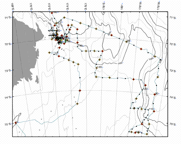 I-1b the primary AnSlope area

I-1c Close up of
mooring region, SW corner of AnSlope Coverage
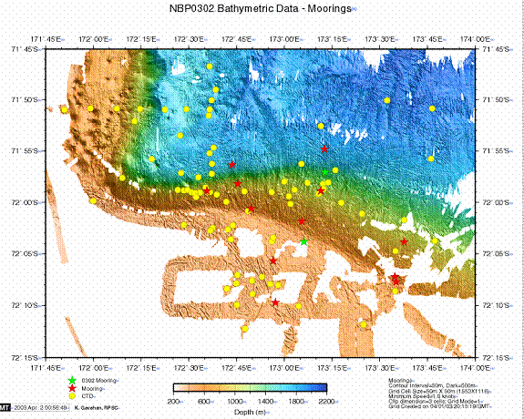
I-1d Multibeam base
of Close up of the SW corner of AnSlope Coverage
Research "Blocks": AnSlope-1 cruise activities may be segmented into research blocks, A to H (Figure I-2). A 'Station' consists of CTD/LADCP; microstructure; water samples; a 'Section' is a sequence of stations, generally with spacing of 5 to 15 nm.
Figure I-2 Map of
Research Blocks
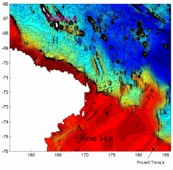
[A] Enroute from McMurdo [stations 1- 18] : The first station was in
[B] Moorings deployment [stations 19- 42]: Deployment of the 12 AnSlope moorings (including the pressure sensor near East-A) with regional CTD / LADCP stations. Tidal currents are a very noticeable part of the flow field, particularly over the shelf. Within the mooring area, over the slope and deeper ocean we find low salinity bottom water spreading westward across the mouth of the Drygalski trough, eventually over-riding saltier slope water derived from Drygalski. While there is general agreement of the stratification observed during AnSlope-1 with that found by Italica [January-February 2003] there is some variability: the Italica data reveals slightly greater extent of the saline slope water.
[C] Western boundary [stations 43-71]: Five closely
spaced sections [5 nm] were obtained across the outer shelf to deep ocean
within the western 'bend' and western boundary formed by the slope isobaths.
These sections show the behavior of the shelf-slope front as the continental
margins executes its abrupt turn. Above 500 m the modified warm deep water
seems to just keep going west, spreading at least to with 15 nm of the shore.
Pressed up against the slope and deeper adjacent ocean is strong northward flow
of saline bottom water. Water mass characteristics and the bottom tracked LADCP
data indicate that there are significant downslope components of salty shelf
water from Drygalski, prompting use of the descriptive word 'Plume'. The
northern cross slope section [stations 67-72] in this grouping defines the
characteristics of the
[D] Northern [D1] and Eastern [D2]
boundary sections [stations 72-97]: The deep water side of the AnSlope
survey region is enclosed by a northern (72-86; nominally along 72°S) and an
eastern (87-97; along 175°E) boundary sections. These sections define the open
ocean boundary condition for the AnSlope area. The northern section crosses the
Iselin Bank near 178°E. The northward protrusion of Iselin Bank forms a major
perturbation to the otherwise SE-NW trending
[E] Pennell Trough [stations 98-110]: Pennell Trough
holds the potential source water for local slope plumes, both ice shelf water
and high salinity shelf water. The latter being similar to that within
Drygalski, but here at its eastern extend it forms a thinner benthic layer.
Within Pennell Trough there are two CLIMA moorings: H-1
75°57.461'S; 177°38.709'W 632-m, and H-2 75°09.936'S; 176°14.603'W 738-m. We took a station at H-2, but ice was
too heavy to spare the fuel to reach H-1. At the shelf break, at H-2, we found
vigorous mixing of the shelf and modified warm deep waters, with very high
offshore speeds, feeding the northward flowing slope waters observed along the
eastern slope of Iselin Bank.
[F] Continental slope crossings [stations 111-144]:
From Pennell Trough to the mooring area we crisscrossed the continental slope
and associated front 8 times (including the two crossings at Pennell and the
175W section) with a station spacing of about 5 nm. These sections examine the
connectivity between the Pennell Trough frontal and plume characteristics with
those at the western mooring area. The southern root of Iselin Bank was
transversed near 73.5S, which with the northern boundary section define the
extent of the Bank's disturbance to the margin stratification/circulation.
There appears to be both low and high salinity benthic water derived from
[G] Recovery/redeployment of two moorings [stations 145-186]: Central E-1 and Central B-1 moorings were recovered and re-deployed as Central E-2 and B-2. E-1 and B-1 were not quite in the desired placement, and E-1 was too shallow exposing it to iceberg impact. The three week mooring records provide a tantalizing hint of things to come when we recover the full year's data. Sections were obtained at close spacing (<5nm at the mooring sites) along the three mooring sections to enable current meter referenced geostrophic calculations. The sections along the eastern and western mooring lines were extended off shore to deeper waters. Repeated lowering (yo-yo station) of the CTD for a period of 25 hours were performed at the ADCP mooring site, revealing very vigorous, time varying conditions.
[H] Balleny Trough [stations 187-206]: The bottom
water formed along the western margin of the
Other Activities:
Ice Observations: Fulfilling a request from Steve Ackley, chairman of the SCAR-GloChAnt ASPeCT program, ice observations were also carried out during the cruise, using the Aspect protocols and software developed at CRC and Australian Antarctic Division by Anthony Worby (see Antarctic CRC Research Report 14, 1999). After a few days of training, a routine of hourly observations was established, under the coordination of Enrico Zambianchi, member of the ASPeCT SSG, and Karl Newyear, involving several volunteer watch standers.
Multibeam: Kathleen Gavahan reports that though the
ice was extensive for most of the cruise we were able to add to the regional
coverage. We have filled a few data
"holes" in the northwestern mooring area, where we have spend most of
the time on this cruise. We had pretty
good coverage there already from NBP0209.
On our excursion to the Pennell area, we added to the definition of the
shelf break. However, because of the ice, the quality of data has been patchy
on this cruise.
Multibeam is an indispensable aid in siting moorings and in understanding the sea floor morphology control of the circulation and mixing processes.
[D] Acknowledgements & comments:
It's been a great cruise! The NBP
is a fantastic ship, staffed with a fine group of capable and congenial people,
across the whole spectrum. We have achieved the objectives of AnSlope cruise 1
under unexpected difficult ice conditions: the moorings have been placed to
best achieve the AnSlope objectives; we have a detailed view of the
stratification and circulation along the margins of the
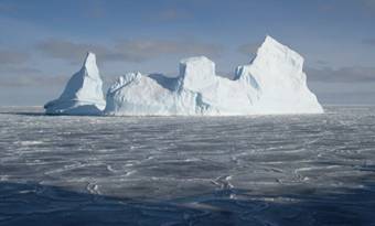
Adding to the science and the company was the natural beauty of the environment. The scenery was spectacular, particularly as the sunrise lit up the snow covered mountains to the west of the mooring area and the icebergs of varied sizes and shapes under flattering lighting conditions. There were many penguin, seal and whale sightings. Food is great, with variety to suit nearly every taste, prepared by a knowledgeable staff. [Though 24 hour availability of better coffee would be good; timely coffee brewed by the Raytheon MT was appreciated (just as I typed out this sentence).]
E-mail policy: the free daily 25K compressed limit is reasonable and the extra cost for additional exchange is not prohibitive to further meaningful use of e-mail. The chief scientist, who often is faced with many additional responsibilities at the home institution and SitReps, should be advised to request in the SIP a free limit of 50K compressed per day.
II CTD/LADCP/Tracer Chemistry [Bruce A. Huber]:
CTD/LADCP/Tracer
Profiles of temperature, salinity, and dissolved oxygen were obtained using equipment provided by RPSC. The basic package consisted of a Sea-bird Electronics SBE911+ CTD system fitted with 2 sets of ducted conductivity-temperature sensors, dual pumps, and a single SBE 43 dissolved oxygen sensor. The sensor suite was mounted vertically on a flat mounting surface just inboard of the lower frame supports. The sensor pairs generally agreed to within 0.001 for both T and C throughout the cruise, and can be used interchangeably. One-second GPS data from the vessel’s Ashtech GPS was merged with the CTD data stream and recorded at every CTD scan. Data were acquired using a PC running Windows 98 and Sea-Bird’s Seasave for Windows software. Raw data was copied over the network to a separate drive immediately after the station. Preliminary post-processing was carried out using batch files and scripts prepared by RPSC and modified by LDEO to provide a variety of CTD products to the AnSlope science party. The processed data was copied to a network disk drive and was generally available within 10 minutes after the conclusion of a station.
All profiles were planned to reach within 10 m of the bottom. Approach to the bottom was guided by a 12 kHz pinger (OSI ) mounted on the frame and an SBE bottom contact switch fitted with a 10 m lanyard and weight. The pinger generally worked well, but required service twice during the cruise to replace the batteries. The bottom contact switch gave sporadic results due to large drifts and bottom currents until station 40, when the original ¼” line and set of large shackles as weights were replaced with a much thinner nylon string and single, 5/8” shackle as weight. From this point on, the bottom contact was for the most part reliable.
Water samples were
collected using a 24-position SBE 32 Carousel sampler with 10 liter water
sample bottles of the SIO Bullister design, modified to include a second,
larger-bore valve adjacent to the standard sampling valve on the body of the
bottle. Water was collected for on-board
analysis of salinity, dissolved oxygen, and CFCs. Salinity and oxygen analyses are primarily
for standardizing the CTD conductivity and oxygen sensors. Additional samples were collected for later
analysis at LDEO of helium, tritium, oxygen-18.
Samples for later analysis of nutrients in
The water sampling system was generally trouble-free, with a few noteworthy exceptions:
- the sample valves on most of the bottles are very difficult to operate. The RPSC marine technicians kept a ready supply of spares to install when a valve became troublesome, but more often than not, this was a temporary fix. This issue should be investigated further by RPSC to determine if there is a flaw in the design or manufacture of the valve assemblies which promotes sticking.
- The latch assembly began to stick on station 100. The assembly was replaced with a spare, but the spare proved to be worse than the original. The original was carefully rinsed and replaced, and further sticking was only occasionally a problem.
- The casousel pylon electronics assembly failed on station 193. A spare was installed from the backup CTD package.
Profiles of water
velocity were obtained with the LDEO Lowered Acoustic Doppler Profiler system
(LADCP). The LADCP underwater system
comprises two RDI Workhorse WH300 ADCPs and an LDEO battery/communications
package. The two ADCP heads (sn 150 and
149) are operated in master-slave configuration, with the down-looking head
serving as master (sn 150).
Oxygen titration
An SBE 43
dissolved oxygen sensor was connected to the primary CTD sensor
array. There was no discernable sensor drift over the time of the cruise
as determined by inter comparison between station pairs at the same location
during the beginning and the end of the cruise. A preliminary correction
was applied based on temperature, yielding close approximation to rosette
bottle data. 1,400 oxygen samples were collected for Winkler titration.
An amperometric titrator, designed by Dr. C. Langdon, was used to titrate whole
bottle samples. The first eight stations were titrated using the RPS
titrator,
after which it was swapped out for the
Salinity determination
 Water
sample salinity was determined using the RPSC Guildline Autosal 8400B
laboratory salinometer(number 59-213) , standardized with batch P141 standard
water from OSIL. Data from the autosal
was captured by computer using an interface and software constructed at Scripps
Oceanographic Inst. The salinometer is
housed in a temperature-controlled enclosure constructed in the Bio Lab. The room temperature at the level of the
salinometer is reasonably well controlled, but we found early on that there was
a nearly 5 degree gradient between the deck and the autosal level. Samples to be run are stored on the deck, and
so were not
Water
sample salinity was determined using the RPSC Guildline Autosal 8400B
laboratory salinometer(number 59-213) , standardized with batch P141 standard
water from OSIL. Data from the autosal
was captured by computer using an interface and software constructed at Scripps
Oceanographic Inst. The salinometer is
housed in a temperature-controlled enclosure constructed in the Bio Lab. The room temperature at the level of the
salinometer is reasonably well controlled, but we found early on that there was
a nearly 5 degree gradient between the deck and the autosal level. Samples to be run are stored on the deck, and
so were not 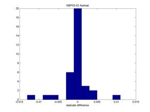 equilibrating
to near the salinometer bath temperature, causing some noisy runs. We installed a circulating fan in the autosal
room, minimizing the floor-to-ceiling temperature gradient. In order to speed
sample processing, sample crates were placed in the aft dry lab sink
immediately after drawing the samples, and the crates filled with tap water. Water was changed 2 to 3 times over the next
few hours, and the resultant water bath temperature checked with a thermocouple
probe provided by RPSC. This procedure
stabilized the sample temperatures to around 20ºC within 6 hours and greatly
improved the stability of the runs.
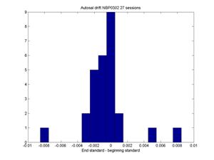
Overall the system works very well.
The combination of SIO interface and software, temperature stability,
and excellent maintenance of the autosal yielded very low drift rates, and good
repeatability of replicate samples. The bulk of the samples were drawn and run
by K. Assmann and E. Curchitser.
equilibrating
to near the salinometer bath temperature, causing some noisy runs. We installed a circulating fan in the autosal
room, minimizing the floor-to-ceiling temperature gradient. In order to speed
sample processing, sample crates were placed in the aft dry lab sink
immediately after drawing the samples, and the crates filled with tap water. Water was changed 2 to 3 times over the next
few hours, and the resultant water bath temperature checked with a thermocouple
probe provided by RPSC. This procedure
stabilized the sample temperatures to around 20ºC within 6 hours and greatly
improved the stability of the runs.
Overall the system works very well.
The combination of SIO interface and software, temperature stability,
and excellent maintenance of the autosal yielded very low drift rates, and good
repeatability of replicate samples. The bulk of the samples were drawn and run
by K. Assmann and E. Curchitser.
