
 |
 |
 |
|
|---|
AGAP S
The Gamburtsev Mountains
The Gamburtsev Mountains
EXTERNAL LINKS
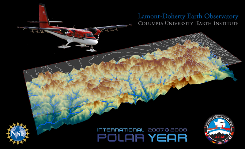
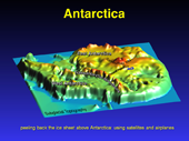
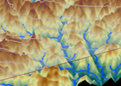
Above is an early visualization of the Gamburtsev Mountain range with the ice 'removed' so we can image what lies below. The graphic is plotted by combining radar ice thickness data from the field campaign, and satellite data from NASA ICESat for surface eleveation contours. Once the data is plotted into a graphic we can begin to examine this expansive mountain range, currently hidden under the weight of many meters of ice. The data reveales a topography that looks more like a sharply chisled river valley than a smoothly carved glacial landscape.
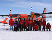
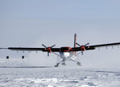
Located in the most remote area of Antarctica, the Gamburtsev Mountains have presented researchers with significant scientific, engineering and human challenges. Discovered over 50 years ago during International Geophysical Year 1957-58, the Gamburtsev Mountains lie deeply buried in East Antarctica. Buried in reference to their geographic location at the furthest point from the perimeter of the continent and the array of international Antarctic bases, as well as buried physically sitting below the highest point on the East Antarctic Ice Sheet, ‘Dome A’, beneath levels of ice measuring up to 3200 meters (~2 miles).
As the project began we knew these mountains were as large as the European Alps, boasting heights of over 3,000 meters and an expanse of 1,200 km, yet we know almost nothing more about them. Unanswered questions focused heavily on their origin and age:
- What tectonic forces created this massive mountain range?
- What else was happening on the planet to trigger this event?
- When did these mountains form? Was it 500 million years ago or 50 million years ago?
- How long the mountains have been encased by the ice?
These questions are being deliberated as the data collected from this project are being processed and analyzed. As the data is examined it is hoped that clues to the formation of this mountainous landscape will be revealed...
Mountain Building
Mountain belts (or ranges) can be built in several ways. In the case of the Gamburtsev Mountains there are several possible theories that have been discussed, but with little data no single mechanism can be supported.
 Volcanic Activity: Volcanoes are most often associated with tectonic plate movement - either where crust is being subduction back down into the interior of the Earth as plates move together (converge) , or where new oceanic crust is being created through crust spreading apart (diverge). Hot spots, however, are examples of volcanoes not associated with plate boundaries. Hot magma or molten rock is forced up from the Earth’s interior to erupt through the surface of the Earth’s crust. Over time this extruded rock builds to form mountains. In the image shown here the hot magma is represented by red arrows forcing its way up through the Earth surface to create the resulting mountain.
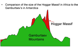 What are some examples of Hot Spot Volcanoes? A familiar series of hot spot volcanoes is the Hawaiian Island chain found in the Pacific Ocean. While we often think of hot spots volcanoes as being found in the ocean, this type of volcano can also occur deep in the interior of a continent. Yellowstone National Park, while much smaller than the Gamburtsev Mountains, is one example of a continental interior hot spot volcano. Perhaps a less familiar example is the one pictured to the left, the Hoggar Massif in the North Central Sahara of Africa. This large mountain range is considered to be a hot spot volcano caused by a mantle plume. The tallest of the Hoggar Massif, Mount Tahat, reaches to 9,573 feet (2,918 meters), certainly within the same anticipated height range as the Gamburtsevs.
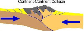 Collision: Mountain belts are formed along colliding boundaries between sections of continental crust. The Earth’s outside crust, is made up of plates (or sections) that fit together somewhat like a puzzle, but the pieces are constantly shifting and slowly moving. When the different plates collide with each other they can push or fold the land up forming raised areas, or mountains. The European Alps and the Himalayas formed this way. The Antarctic continent has collided with other pieces of continental crust over the years (see Antarctic Information), although many believe this section of East Antarctica has been far removed from these collisions.
Rifting: Movement of large sections of crust can force apart the Earth. This pulling apart of the crust can cause one section to uplift forming mountains. The mountains that rim the Red Sea and are along the edges of the African rift lakes formed this way.
Volcanic? Collisional? Rifting? None of these activities has happened recently in East Antarctica. This region is a very old and stable piece of continental crust. There is no good explanation for how this mountain range exists in a formation that geologists refer to as a Precambrian craton (an old stable piece of the continent that has survived untouched by continental break ups and rearrangements over the last ~500 my). It is like opening the door of an Egyptian pyramid and finding an astronaut inside. There is no good reason for an astronaut to be inside an Egyptian pyramid just as there is no good reason for a major mountain range in the middle of East Antarctica.
This project will collect data that will help us answer how these mysterious mountains were formed, and how they might relate to the rest of the Antarctic continent formation.
