
 |
 |
 |
|
|---|
AGAP S
Ice Cores
Ice Cores
EXTERNAL LINKS
What is a core and how is it collected?
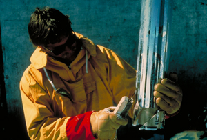 |
| Photo Credits:Kendrick Taylor, DRI, University of Nevada-RenoImage source http://www.ncdc.noaa.gov/paleo/slides/slideset/ |
Collecting a core refers to cutting and removing a cylindrical section of a sample or substance, much like coring an apple involves taking a cylindrical section of the apple. The coring is done so that the section of material sampled is not crushed or compressed, but ‘cut’ in a fairly intact manner, retaining original layering and positioning.
In studying the Earth many different types of cores are collected, each type offering a different kind of information about the Earth and its history. Some scientists collect sediment cores from the bottom of the ocean using long hollow tubes, which are pushed into the sediment collected on the ocean floor. Other scientists collect rock cores by drilling a hollow metal tube into the Earth and removing a section of rock. And still other scientists drill into layers of ice to collect long cylindrical sections of accumulated ice. The image to the left shows the bottom of an ice drill; the cutter head (the part that cuts the ice) and the core barrel, (the hollow tube that follows the cutter head to capture and hold the ice as it is extracted.)
Each of these types of cores represents a glimpse into the past; a layered collection of information about past climates, Earth processes and major events. In examining a core it is important to recognize that older information will be buried deeper down in the core (the geologic principle of 'superposition'). The closer to the surface you travel up a core, the closer the events, or time represented, are to the present. Think of the core as a vertical scale, the higher you climb up the scale the more recent the information. In order to determine just how much time is represented in a core, precise analysis and chemical testing is done.
What can we learn from an ice core?
 |
image credit Anthony Gow |
Scientists travel to the ends of the Earth to gather ice cores…but why? Scientists will tell us that ice cores offer direct climate information. Ice cores are a sample of layers of snow and ice that have collected over a period of a series of years that offers a continuous record of events and conditions. Falling snow captures the atmosphere through which it travels, collecting the chemistry, particles and compounds that are present - these include bits of dust, trace metals, or radioactivity. In extreme climates the snow remains all year, with each year's snow contribution being sealed with each subsequent year's snow accumulation. This means that all this information trapped in the snow is being captured and sealed in place.
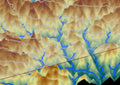
As snow is layered it compresses, and over time the lower layers are turned into ice, capturing small samples of the atmosphere as air bubbles. These natural ice archives with trapped chemicals, dust and air, can hold a a tremendous amount of information for scientists. Past climates and temperatures, large scale Earth events such as volcanic eruptions, atmospheric changes, ice accumulation rates over time, changes in vegetation and human impacts on the overall Earth system through emissions of gases and chemicals are all information that is captured in ice cores. Scientists can use other methods to try and determine past climates, but ice cores provide continuous, direct, high resolution information which can provide annual, as well as seasonal information. The image shown above is an example of seasonal and annual ice layering within an ice core. This 19 cm section of a Greenland ice core (GISP 2) was extracted from a depth of 1855 m. This ice section contains 11 annual layers, which are illuminated with special lighting to show the narrower summer layers (farrowed) sandwiched between darker wider winter layers.
How does an ice core relate to this project?
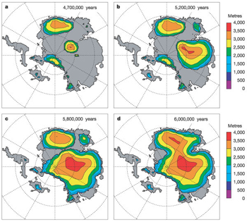 |
| Image from the following article: Rapid Cenozoic glaciation of Antarctica induced by declining atmospheric CO2; Robert M. DeConto and David Pollard; Nature 421, 245-249(16 January 2003); doi:10.1038/nature01290 |
While the majority of partners involved in this project are focused on airborne geophysical measures of the area, the Chinese have completed several overland traverses by tractor to the project site, Dome A. They plan to construct a science research base in this area and complete a series of studies, including drilling the Earth's oldest ice core, in order to examine climate history for the last 1.2 to 1.5 million years. Where is the best place to drill this ice core?
Glaciers begin to form in areas where there is sufficient snow, and the area is cold enough for snow to remain on the ground year-round. If each year the new snow amounts exceed any melt that occurs, layers of snow gradually accumulate compressing into ice. Each year's snowfall contributes to a growing glacier. Glaciers develop in mountains as temperature decreases with elevation, so the Gamburtsev Mountains would be an expected origin for the glacier that developed into the Antarctic Ice Sheet.
Scientific models are ways that scientists can look at possible explanations for large scale processes that they can't directly observe. Scientists have modeled ice formation in East Antarctica as it transitioned from a more temperate environment to an icy continent. The graphic series shown here is from DeConto and Pollard. It shows a modeled progression of ice build up on the continent starting some 34,000,000 years ago. The model suggests that ice began to build in three sections of East Antarctica - Dronning Maud Land, the Gambertsev Mountains and the Transantarctic Mountains. After the model progresses for 300,000 years the ice sheet approximates present conditions, covering the majority of the continent, with the deepest and oldest section of ice still located over the Gamburtsev Mountains.
Currently there is limited data for this area of East Antarctica because it is so difficult to access, but we do have information on the age of the ice in one critical location...Lake Vostok. Lake Vostok, lies East of the Gamburtsev Mountains. Lake Vostok ice cores and radar data has been the focus of international study for several years. By flying a series of long flight lines between Lake Vostok and the Gamburtsev Mountains we can connect the radar data from this missing interior area to Lake Vostok's existing data. This data will be available to assist China in selecting where to drill their ice core.
