|
|
|---|
Ice Bridge
Project Overview
Project Overview
Lamont-Doherty Earth Observatory
EXTERNAL LINKS
Laser, Radar, Gravity
 |
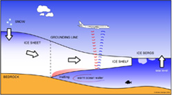
With the pending retirement of ICESat I, NASA's will launch an instrumented DC-8 aircraft to continue the collection of crucial ice sheet data at the poles. The DC-8 plane will be loaded with a suite of geophysical instruments including: a lidar laser system from NASA (Airborne Topographic Mapper - ATM), to measure the surface elevation of the ice sheet; multichannel coherent radar depth sounder (MCORDS) from CRESIS of the University of Kansas, to measure the internal structure of the ice sheet and ice sheet thickness; a Sander Geophysics AIRGrav system from the Lamont-Doherty Earth Observatory, to measure gravity as a tool for determining water depth under floating glaciers. The combination of these instruments will allow ICE Bridge to collect a unique suite of measurements, gathering a time series of data on both the the ice sheet surfaces, the ice sheet structure and the underlying surfaces.
Antarctica Seasonally beginning in 2009
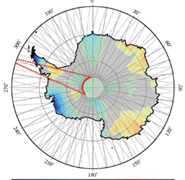
 Flight Plans: The Antarctic flights began in October 2009 flying out of Punta Arenas, Chile. Punta Arenas, the largest city in the Southern end of Chile, is marked by a star on this NASA satellite image. Flights will depart and return to Punta Arenas on the same day as conditions do not allow for the plane to land in Antarctica. Each season approximately 20 flights are scheduled over a short period of 38-40 days. A flight for every 2 days may seem luxurious, but with winds and weather being highly unpredictable, and the impact from the cold on the planes and equipment, this is a very aggressive schedule.
The aircraft will overfly ICESat ground tracks in areas of interest as well as repeat some of the key flight lines collected during three previous West Antarctic ATM/radar campaigns (2002, 2004 and 2008). This plan will provide a continuous history of the changing ice sheets and new insight on both how and why ice sheets change.
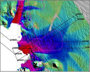
One of the key flight areas is the Amundsen Coast region, which includes the Pine Island, Thwaites, Smith and Kohler glaciers, the Devicq Glacier and the Getz Ice Shelf. A second key area is the Antarctic Peninsula. Both are areas of interest as a result of the rapid changes that have occurred in the ice shelves in these regions. Included in Peninsula survey area will be the Larsen-C Ice Shelf, that section of the Larsen Ice Shelf that remains after the January 1995 collapse of Larsen-A followed by the spring 2002 dramatic collapse of Larsen-B.
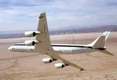
 Flight Weight: Although the interior of the plane looks spacious, the weight of the instruments being loaded for the survey, and the fuel needed to complete the round trip flights, makes plane weight an important issue. Careful measurements have been completed to determine exact weights of each piece of equipment and how much additional weight can be allotted for personnel. Any extra seating in the aircraft has been removed to save the weight. Negotiating spots on the plane is difficult, with even the science staff having to rotate flights on the plane.
 Preparations: The flight preparations are being completed in the California desert at NASA's Dryden Research Center near Edwards Air Force Base. The desert location offers excellent weather for flying, a reason that Edwards serves as the weather backup landing location for the space shuttle. However, the need to check for scorpions, tarantulas and rattlers in the buildings provides an odd juxtaposition to the upcoming polar trip. The remote desert area allows the pilots ample room to test fly much of the equipment to determine compatibility, interference and accuracy.
 Instruments: The instruments being used are very sensitive. Each instrument is carefully located on the aircraft to minimize the interference with other instruments and to ensure optimal data collection. Scientists hope to be able to use twitter as a means of communicating 'real time' what they were observing.