Mapping Dissolved Organic Carbon in Eastern U.S. Coastal Waters Using Ocean Color Satellite Data
Principal Investigator: A. Subramaniam, Lamont Doherty Earth Observatory
CoInvestigators: R. Del Vecchio, University of Maryland
J.R. Nelson, Skidaway Institute of Oceanography
Funding source: NASA Carbon Cycle Science NRA 04-OES-01
North American Carbon Program
This project will investigate the relationships between DOC and CDOM, and between carbon and ocean color. Data from historical and ongoing fieldwork will be used to study the spatial and seasonal distribution of DOC, along with inherent and apparent optical properties, for the coastal and continental shelf regions along the east coast of the U.S. We also intend to further investigate photodegradation of DOC to dissolved inorganic carbon (DIC) during summertime and link it to bleaching of CDOM. The combined dataset will be used to develop an algorithm to map DOC from the DOC-to-CDOM dependence using satellite ocean color sensors. Yearly time-series of DOC maps for the east coast of the U.S. will be constructed, thus allowing us to explore the spatial and temporal variability, as well as long-term changes if any, in this parameter with strong emphasis on the processes driving DOC distribution, transformation and transport. This proposal addresses an area of primary interest for NASA in the North American Carbon program by bringing remote sensing to bear on characterization of carbon stocks, transport and transformations of terrestrially derived organic carbon in the coastal waters off the eastern United States.
Goals
The goals of the proposed research are to map DOC (and terrigenous CDOM) and to compile a long-term dataset to that will allow us to better define the processes driving the distribution, transformation and transport of dissolved organic carbon in the coastal ocean off the eastern U.S.
- The spatial and temporal variation of DOC (and CDOM) and water leaving reflectance will be investigated for the eastern U.S. coastal waters.
- Loss of DOC upon light exposure will be estimated for each region (MassBay, MAB, SAB).
- Regional algorithms for retrieving DOC concentrations from CDOM absorption based on ocean color will be developed.
- These algorithms will be applied to the coastal ocean color datasets to provide the yearly data set to study the seasonal and interannual changes DOC concentration along the east coast of the U.S.
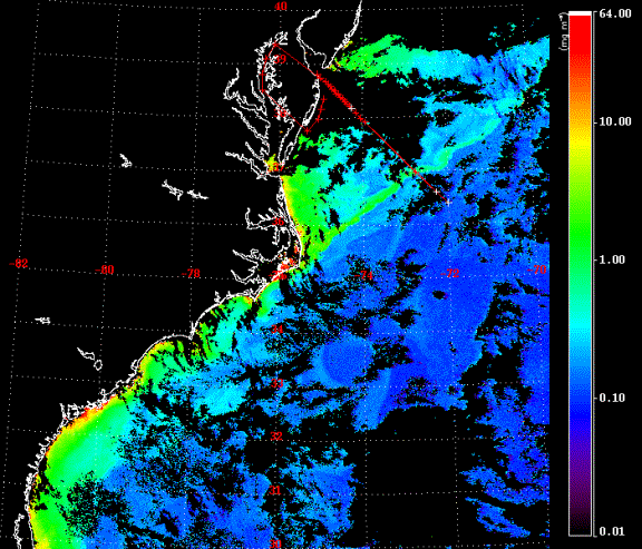
Figure 1 SeaWiFS image of
chlorophyll concentrations in the Mid and South Atlantic Bights from 9
Oct.
1999. A fresh water plume is seen as a
jet of high “chlorophyll” extending from the Outer Banks.
The OCT99MAB cruise track and stations
occupied during the entire cruise described in Subramaniam (2000) are
shown in
red with the stations sampled on the same day as this image shown in
white. Our in-situ measurements showed
that this jet had extremely high CDOM absorption and was the runoff
after three
Hurricanes – Dennis, Floyd, and Irene had passed over North Carolina. Paerl et al (2001) found a doubling of
surface DOC in Pamlico Sound as a consequence of the hurricanes. The transect from the Delaware Bay mouth to
the Sargasso Sea has been occupied 5 times during various seasons from
1996 to
2000 and the in-situ data are described in Johannessen et al., 2003;
Del
Vecchio and Blough, in press).
We propose to create maps such as
this that show absorption due to CDOM and DOC concentrations instead of
chlorophyll concentrations.
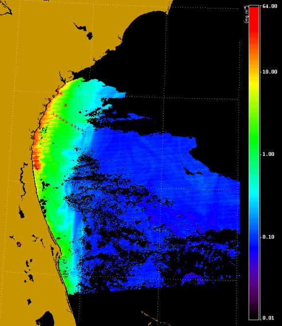
Figure 2 Chlorophyll concentrations in the South Atlantic Bight derived from MODIS data. The stations visited on the MAY05SAB field survey on 12 and 13 May are indicated by * and + respectively. The high apparent “chlorophyll concentrations” seen along the coast may be a consequence of the record rainfall over the South East this spring.