Lau Basin Float Experiment (LAUB-FLEX)
The LAUB-FLEX project has formally ended. As long as I keep
receiving data from the surviving floats, I will periodically update
this page every few months.
[Get the float data here.]
Rationale
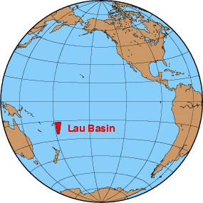 Before this
experiment was begun in 2004, little was known about the ocean
circulation in the Lau Basin, one of the RIDGE 2000 hydrothermally
active Integrated Study Sites, where coordinated interdisciplinary
experiments are being carried out between 2004 and 2010. Knowledge of
the oceanic circulation is required in order to answer important
questions of hydrothermal research. The near-vent-field velocities are
required, for example, if fluxes of heat and chemicals associated with
the hydrothermal plumes are to be estimated. On a larger scale, the
regional flow field severely constrains the dispersal pathways of the
larvae of hydrothermal animals and, as a consequence, the biogeography
of vent organisms. Because of these considerations, determination of
the regional circulation in the Lau Basin has been made a priority in
the Lau Basin implementation plan.
Before this
experiment was begun in 2004, little was known about the ocean
circulation in the Lau Basin, one of the RIDGE 2000 hydrothermally
active Integrated Study Sites, where coordinated interdisciplinary
experiments are being carried out between 2004 and 2010. Knowledge of
the oceanic circulation is required in order to answer important
questions of hydrothermal research. The near-vent-field velocities are
required, for example, if fluxes of heat and chemicals associated with
the hydrothermal plumes are to be estimated. On a larger scale, the
regional flow field severely constrains the dispersal pathways of the
larvae of hydrothermal animals and, as a consequence, the biogeography
of vent organisms. Because of these considerations, determination of
the regional circulation in the Lau Basin has been made a priority in
the Lau Basin implementation plan.
After a preliminary analysis of
(sparse) hydrographic data was carried out, we (Andreas Thurnherr and
Kevin Speer) submitted a proposal to the National Science Foundation
(NSF) to study the deep flow field in the Lau Basin with autonomous
floats autonomous floats] that are programmed to drift at the depth of
the hydrothermal plumes (approximately 1800m). The floats periodically
return to the surface in order to obtain their positions and to
transmit their data back to shore using satellites. In
2003, NSF funded the proposal and, as a result, 5
APEX and 10 PROVOR
floats were deployed during three scientific expeditions to the region
in 2004 and 2005. Out of the 15 floats, 3 Metocean and 1 APEX failed
during deployment. Two of the Metocean failures were later diagnosed as
ballasting errors. As of May 2011 7 floats are still returning data,
confirming prior expectations that there have been near-real-time
velocity measurements available during the entire duration of the RIDGE
2000 experiments in the Lau Basin.
In addition to providing
background data that are required to interpret hydrothermal-plume
dispersal observations and biogeographic patterns, the float
trajectories also provide the first measurements of the deep
circulation in the Lau Basin, yield new insights into processes acting
in confined basins and near rough topography, and they may also be
useful for improving numerical circulation models.
Results
Because typical velocities in the ocean are similar to the speed of
a garden snail the first set of floats was programmed to return to
the surface once every 4 weeks. At the surface the expected velocities
are 10-100 times larger, especially during storms. Therefore, it is
important that the floats spend much more time at depth than at the
surface, where they have to remain for a minimum of about 10 hours in
order to be able to transmit all their data. Because of the
unexpectedly strong 4-week averaged flow observed by the first batch of
floats, the cycling interval was reduced to 3 weeks for the remaining
instruments.
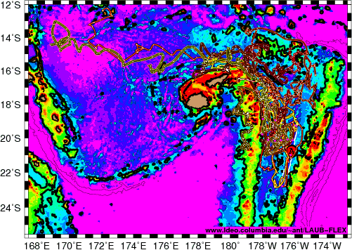
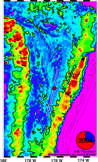
The figure on the right shows the float trajectories.
(Click here for
an animation and here for the data files. Some web browsers have
problems displaying large animated gifs - it may be useful to download
and save the animation and display it with a better gif-animation
viewer, such as the QuickTime player on MacOSX.) The floats are
programmed to drift along a surface of constant pressure of 1750dbar,
which corresponds to a depth of approximately 1730m. This depth was
chosen to be as close as possible to the depth of the hydrothermal vent
fields known at the time of deployment (1730-1850m), while being
shallow enough so that the floats would not run aground very often.
(While the floats are designed to be able to run aground without being
damaged we nevertheless try to avoid that.)
After several years of
float measurements some aspects of a mean circulation have become
apparent. Initially, all the floats from the first batch deployed in
the eastern Lau Basin were heading north, consistent with the
hydrographic
analysis. Later, however, the situation has become much less clear.
A few observations stand out:
- overall, the flow in
the Lau Basin is predominantly westward and
northward
- most of the floats which have left the Lau Basin did so
through the deep passage north of Fiji
- the available float tracks "cluster" in the western Lau Basin, primarily
between ~17° and 21°S
- there are indications of a strong northward boundary current along the
western rim of the basin
- even though the flow along the ELSC is predominantly
northward, a float deployed on the ELSC near 20°S drifted
to the southern end of the spreading center after two years
before turning northward
The fact that several-week-long mean flow in all directions was
observed over the spreading center (blue line) has important
consequences for the regional biogeography as dispersal on time scales
of weeks is omnidirectional. In this context is it interesting to note
that there are several instances when multiple floats changed their
drift directions approximately at the same time, suggesting that the
temporally variable circulation in the Lau Basin may be horizontally
coherent over large areas.
The cycle-averaged drift velocities recorded during the first three
years peak at just under 9 cm/s. Even the more typical speeds between 1
and 2 cm/s are significantly stronger than expected from the
hydrographic analysis. The reason for this discrepancy is not known. It
is possible that the hydrographic data were collected during a lull in
the deep flow.
Regardless of the floats' future behavior we already know a lot more
about the deep circulation in the Lau Basin than we knew before the
first float was deployed. As is usually the case in observational
physical oceanography, the ocean turns out to be more complex than
previously imagined. Therefore, the experiment can already be called a
success!
[The material found on this page is based upon work supported by the
National Science Foundation under Grant No. 0241785. Any opinions,
findings, and conclusions or recommendations expressed in this material
are those of the author and do not necessarily reflect the views of the
National Science Foundation.]