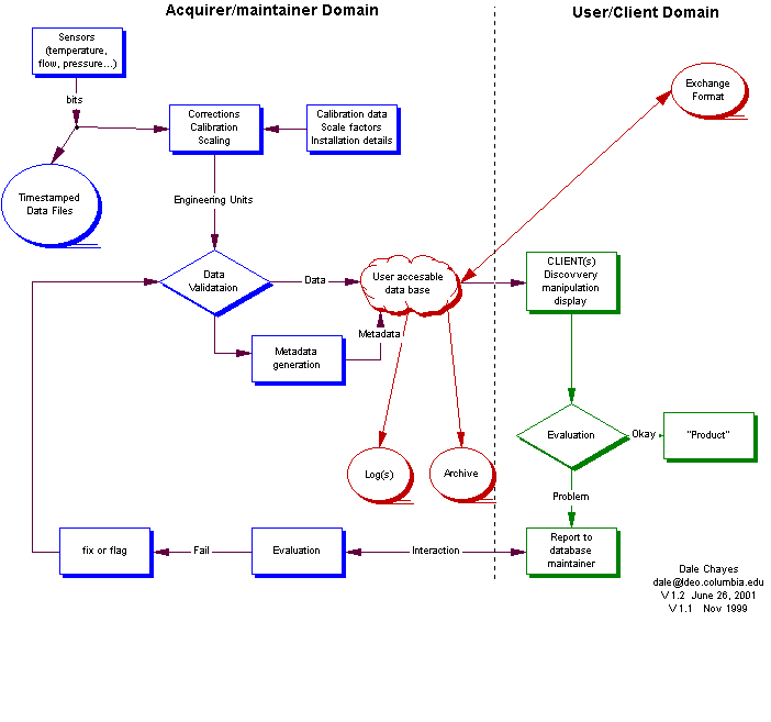
As outlined in the figure below, one can think of the "stuff" that
comes out of sensors as "bits" (or bytes or words) that
have to be scaled and calibrated before they can be viewed into commonly
used units (such as temperature in degrees
or phase angle in radians.) Once these "corrections" have been made
these numbers can be evaluated for
"reasonableness" (for want of a better term). The output of this validation
step can be thought of as data.
Once there is "data", it is appropriate to add it to a "database" of some sort. Historically, this is likely to be flat file although of late some have come to think of geographic information systems (GIS) as a kind of database.
I've (slowly) come to believe that it's most effective for the metadata to reside in a relational database that can be effectively and efficiently searched using standard query languages (perhaps best embedded in a suitable client.) Such queries result in in pointers (persistent resource locators) from which the underlying ("real") data can be obtained.
Users interacting with the data may turn up further questions about the validity of the data. There should be a clear and responsive path to feed this information back to the maintainers so that the data quality can be improved.
It is crucial that the raw (bits) be archived w/ accurate time stamping in the event that it is necessary to recover from any of a wide variety of possible errors such as firmware upgrades to the sensors, changes in calibration coefficients, etc.
The database must be backed up up to recover from various kinds of disasters (such as fire, flood, or failed updates.)
It is important that these issues get fed back to the data maintainers
by some path other than direct user manipulation
of the database.
The following diagram may help illuminate the discussion:
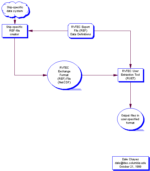 For discussion purposes, lets assume that we are not going to have substantial
impact on the behavior of the exiting ship's data systems. However, we
can elect to define the exchange file format to include required as well
as optional "fields". For instance, we could require that the file contains
the raw (as generated) binary data and the calibration coefficients and
allow an optional fields for scaled (engineering) units.
For discussion purposes, lets assume that we are not going to have substantial
impact on the behavior of the exiting ship's data systems. However, we
can elect to define the exchange file format to include required as well
as optional "fields". For instance, we could require that the file contains
the raw (as generated) binary data and the calibration coefficients and
allow an optional fields for scaled (engineering) units.
Created:
Posted: September 9, 1999
Updated: October 30, 1999
(content)
Updated: December 22, 2004 (spelling)
By: Dale Chayes,
LDEO/CU, (c) LDEO/Columbia University
Questions, comments etc. to: Dale
Chayes