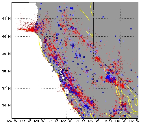
Double-difference Earthquake Catalog for Northern California (1984-2003)

Data and Methods
This catalog is based on a simultaneous re-analysis of two decades (1984-2003) of the digital seismic archive of Northern California. Waveform cross correlation (CC) and double-difference (DD) methods are used to improve the resolution in hypocenter locations in the existing earthquake catalog generated at the Northern California Seismic Network (NCSN) by up to three orders of magnitude (see Waldhauser and Schaff, 2008, for details). We used a combination of ~3 billion CC differential times measured from all correlated pairs of events that are separated by less than 5 km (Schaff and Waldhauser, 2005) and ~7 million P-wave arrival time picks listed in the NCSN bulletin. The data was inverted for precise relative locations of 311,273 events using the DD algorithm (Waldhauser and Ellsworth, 2000).

Results I: Correlations
About 90% of the earthquakes have correlated P- and S-wave trains at common stations, and 12% are co-located repeating events. An analysis of the repeating events indicates that uncertainties at the 95% confidence level in the existing network locations are on average 0.7 km laterally and 2 km vertically. Correlation characteristics and location improvement are remarkably similar across most of Northern California, implying the general applicability of these techniques to image high-resolution seismicity caused by a variety of plate-tectonic and anthropogenic processes. These results indicate that consistent long-term seismic monitoring and data archiving practices are key to increase resolution in existing hypocenter catalogs, and to estimate the precise location of future events on a routine basis.

Results II: Relocations
The relocated catalog is able to image the fine-scale structure of seismicity associated with active faults, and reveals spatio-temporal characteristics such as streaks and repeating earthquakes.

San Andreas/Calaveras Mendocino

Figures showing epicenters before (NCSN, left) and after (DD, right) relocation demonstrate the location improvment achieved over existing locations. Click on thumbnail for full-size figure.

Long Valley Geysers

For more details see:
Waldhauser, F. and D.P. Schaff (2008), Large-scale relocation of two decades of Northern California seismicity using cross-correlation and double-difference methods, J. Geophys. Res., 113, B08311, doi:10.1029/2007JB005479. [PDF]
Schaff, D.P. and F. Waldhauser (2005), Waveform cross-correlation-based differential travel-time measurements at the Northern California Seismic Network, Bull. Seism. Soc. Am., 95, 2446-2461. [PDF]

Download the DD catalog in ASCII format: NCAeq_DD.1984-2003.v1.0.

For some LiveGraphics 3D animations of selected areas of seismicity click here.

The following institutions contributed with their seismic networks to the NCSS data used in this study: U.S. Geological Survey, Menlo Park; University of California, Berkeley; California Institute of Technology; University of Nevada, Reno; California Division of Water Resources; University of Utah; University of Southern California. The seismic archives were obtained from the Northern California Earthquake Data Center (NCEDC) and the Northern California Seismic Network (NCSN).