Sediment Processes in Complex Estuarine and Coastal Environments
Coastal areas and estuaries are focal points for human development. Understanding the sediment dynamics of these areas is essential for successfully managing the resulting economic and environmental needs. In addition, estuaries are also the major link for the exchange of sediment and nutrients between land and oceans. For more than 10 years I have been studying sediment processes in the Hudson River Estuary. As part of the Hudson River Benthic Mapping Project I have acquired and processed seismic, sidescan sonar and sediment data from the entire 240 km of the Hudson River Estuary. I integrated and interpreted these data with multibeam bathymetry collected by Stony Brook University, which resulted in the first, comprehensive bottom characterization of an estuary of this size (Nitsche et al., 2005a). As part of this project, I developed new automatic classification techniques, to distinguish areas with different bottom characteristics (Nitsche et al., 2005b), and a new process-based classification scheme (Nitsche et al., 2004). Using GIS techniques I determined the distribution of sediment along the Hudson River Estuary, revealed general trends, and identified significant local variations that are probably linked to bedrock, tributaries, and anthropogenic modifications (Nitsche et al., 2007). Besides analyzing sediment processes and distribution I have been collaborating with biologists from the Institute of Ecosystem Studies and Stony Brook University to link benthic mapping results to actual habitats (Strayer et al., 2006). Based on this extensive dataset, I have worked with geochemists to quantify sediment deposition and its variation in the Hudson River (Kenna et al., 2011). Our results show that deposition and erosion is much more complex than previous models assume and that dredged areas are a focus point for deposition (Nitsche et al., 2010). In a recently funded study we will study changes in the sediment distribution resulting from the recent storms Irene and Sandy.
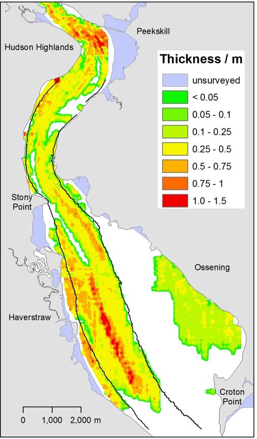
Example of sediment thickness in Haverstraw Bay, Hudson River (Nitsche et al., 2010)
- Nitsche, F.O., Bell, R., Carbotte, S.M., Ryan, W.B.F., Flood, R., 2004. Process-related classification of acoustic data from the Hudson River Estuary. Marine Geology 209, 131-145.
- Nitsche, F.O., Bell, R.E., Carbotte, S.M., Ryan, W.B.F., Flood, R.D., Ferrini, V., Slagle, A., McHugh, C.M.G., Chillrud, S., Kenna, T., Strayer, D.L., Cerrato, R.M., 2005a. Integrative acoustic mapping reveals Hudson River sediment processes and habitats. Eos Trans. AGU 86, 225, 229.
- Nitsche, F.O., Carbotte, S., Ryan, W., Bell, R., 2005b. A seabed classification approach based on multiple acoustic sensors in the Hudson River Estuary, in: FitzGerald, D.M., Knight, J. (Eds.), High-resolution morphodynamics and sedimentary evolution of estuaries. Springer, Netherlands, pp. 33-55.
- Nitsche, F.O., Kenna, T.C., Haberman, M., 2010. Quantifying 20th century deposition in complex estuarine environment: An example from the Hudson River. Estuarine, Coastal and Shelf Science 89, 163-174.
- Nitsche, F.O., Ryan, W.B.F., Carbotte, S.M., Bell, R.E., Slagle, A., Bertinado, C., Flood, R., Kenna, T., McHugh, C., 2007. Regional patterns and local variations of sediment distribution in the Hudson River Estuary. Estuarine, Coastal and Shelf Science 71, 259-277.
- Kenna, T.C., Nitsche, F.O., Herron, M.M., Mailloux, B.J., Peteet, D., Sritrairat, S., Sands, E., Baumgarten, J., 2011. Evaluation and calibration of a Field Portable X-Ray Fluorescence spectrometer for quantitative analysis of siliciclastic soils and sediments. Journal of Analytical Atomic Spectrometry 26, 395-405.
- Strayer, D.L., Malcom, H.M., Bell, R.E., Carbotte, S.M., Nitsche, F.O., 2006. Using geophysical information to define benthic habitats in a large river. Freshwater Biology 51, 25-38.
- New York State Department of Environmental Conservation (NYS DEC)
- Imaging the Hudson before humans (CU blog entry)
- Stony Brook University
- Queens College, CUNY
- Cary Institute of Ecosystem Studies