Click on the image at left for a larger version.
| Previous |
4.2. Magmatism, Rifting, and Drifting
4.2.1. Basin Evolution (Supercontinent Breakup)
by the Basin Evolution Breakout Group
Roy W. Schlische, Co-Leader, Rutgers University, Piscataway,
NJ, USA
Martha O. Withjack, Co-Leader, Mobil Technology Company,
Dallas, TX, USA (present address: Rutgers University, Piscataway, NJ, USA)
James A. Austin, University of Texas-Austin, Austin,
TX, USA
David E. Brown, Canada--Nova Scotia Offshore Petroleum
Board, Halifax, N.S., Canada
Juan Contreras, CICESE, Ensenada, B.C., Mexico
Elizabeth Gierlowski-Kordesch, Ohio University, Athens,
OH, USA
Lubamir F. Jansa, Dalhousie University, Halifax, N.S.,
Canada
Maryanne L. Malinconico, L-DEO, Columbia University,
Palisades, NY, USA
Joseph P. Smoot, U.S. Geological Survey, Reston, VA,
USA
Robert P. Wintsch, Indiana University, Bloomington,
IN, USA
Science Issues
Fault-bounded rift basins and the structures they contain
are the upper-crustal manifestation of continental extension (Figures 4.2.1.1,
4.2.1.2, and 4.2.1.3) (see also Section 3.3.1).
The sedimentary fill of rift basins represents the complex interaction
among basin capacity (accommodation space), sediment supply, available
supply of water, and, in some cases, eustatic sea-level change (see Figures
3.3.1.3 and 3.3.1.6). Within the realm of tectonics and basin evolution,
our breakout group identified three important issues related to rift-basin
development and the breakup of the Pangean supercontinent. These
are: 1) the spatial variability of the structure and stratigraphy
of rift basins and rift systems, 2) the structural and stratigraphic evolution
of rift basins and rift systems; and 3) the transition from rifting to
drifting.
|
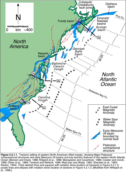
Figure 4.2.1.1. Tectonic setting of eastern North American
rifted margin, showing major Paleozoic compressional structures and early
Mesozoic rift basins and key tectonic features of the eastern North Atlantic
Ocean (Benson and Doyle, 1988; Klitgord et al., 1988; Manspeizer and Cousminer,
1988; Costain and Coruh, 1989; Olsen et al., 1989; Tankard and Welsink,
1989; MacLean and Wade, 1992; Sheridan et al., 1993; Rankin, 1994). Thick
dashed lines and squares with notation show location of transects in Figure
4.2.1.2; purple lines and ellipses with notation show location of sections
in Figure 4.2.1.3. [Modified from Withjack et al., 1998.]
Click on the image at left for a larger version. |
Spatial variability of structure and stratigraphy within rift basins and rift systems
The Triassic-Jurassic Pangean rift system, found on the
conjugate continental margins of the central Atlantic Ocean, covers an
enormous geographic area (see Figure 2.3). Thus, the Pangean rift
system would provide valuable information about the spatial variability
of the structures and stratigraphy within rift basins and rift systems.
Core data, supplemented with outcrop and seismic data, from these continental
margins would allow us to address the following questions: (1) Did
rifting initiate at the same time along the margin? (2) Were there
variations in the duration of rifting along the margin? (3) How do
the pre-rift structures vary along the margin and how did these pre-rift
structures influence the development of the syn-rift structures?
(4) Did the direction of regional extension vary spatially along the margin?
(5) Did the lithospheric and crustal rheology, strain rates, and heat flow
vary spatially along the margin? (5) What were the relative controls
of tectonics and climate on stratigraphy, and how did these vary spatially?
(6) How do geologic structures (both rift structures and older, preexisting
structures; Figure 4.2.1.1 and 4.2.1.2), drainage patterns, and provenance
control the distribution of facies in the rift-basin fill?
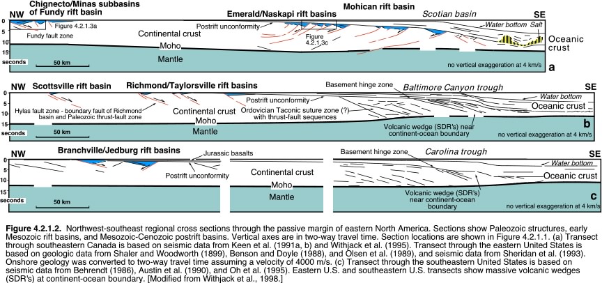 |
| Figure 4.2.1.2. Northwest-southeast regional cross sections
through the passive margin of eastern North America. Sections show Paleozoic
structures, early Mesozoic rift basins, and Mesozoic-Cenozoic postrift
basins. Vertical axes are in two-way travel time. Section locations are
shown in Figure 4.2.1.1. (a) Transect through southeastern Canada is based
on seismic data from Keen et al. (1991a, b) and Withjack et al. (1995).
Transect through the eastern United States is based on geologic data from
Shaler and Woodworth (1899), Benson and Doyle (1988), and Olsen et al.
(1989), and seismic data from Sheridan et al. (1993). Onshore geology was
converted to two-way travel time assuming a velocity of 4000 m/s. (c) Transect
through the southeastern United States is based on seismic data from Behrendt
(1986), Austin et al. (1990), and Oh et al. (1995). Eastern U.S. and southeastern
U.S. transects show massive volcanic wedges (SDR's) at continent-ocean
boundary. [Modified from Withjack et al., 1998.]
Click on the image above for a larger version. |
Rift Basin/Rift System Evolution
The continuous record supplied by coring, coupled with
outcrop and seismic studies and basin modeling, would also allow us to
address the following important questions related to the temporal development
of rift basins and rift systems: (1) How do the dimensions of rift
basins and the rift system change through time? (2) What does this
tell us about the nature of fault growth, fault linkage, and the localization
of strain? (3) Does the presence of multiple unconformity-bounded
tectonostratigraphic packages (see Figure 3.3.1.8) imply that extension
is episodic, or are these packages the result of the relatively localized
processes of fault growth and linkage? (4) Is extension represented
by older tectonostratigraphic packages related to orogenic collapse or
supercontinent breakup? (5) What process or processes are responsible
for the tripartite stratigraphic packages common to so many non-marine
rift basins (see Figure 3.3.1.5)? (6) What were the relative controls of
tectonics and climate on stratigraphy and how did these vary temporally?
Click on the image above for a larger version. |
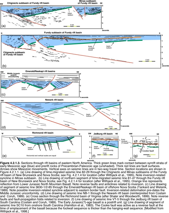
Figure 4.2.1.3. Sections through rift basins of eastern North America. Thick green lines mark contact between synrift strata of early Mesozoic age (blue) and prerift rocks of Precambrian-Paleozoic age (unshaded). Thick red lines are fault surfaces. Arrows show Mesozoic movements. Vertical axes on seismic lines are in two-way travel time. Section locations are shown in Figure 4.2.1.1. (a) Line drawing of time-migrated seismic line 82-29 through the Chignecto and Minas subbasins of the Fundy rift basin of New Brunswick and Nova Scotia; see Fig. 4.2.1.4 for location (after Withjack et al., 1995). Note inversion-related syncline in Minas subbasin. (b) Line drawing of northern segment of time-migrated seismic line 81-47 through the Fundy rift basin of New Brunswick and Nova Scotia; see Fig. 4.2.1.4 for location (after Withjack et al., 1995). Orange line represents reflection from Lower Jurassic North Mountain Basalt. Note reverse faults and anticlines related to inversion. (c) Line drawing of segment of seismic line 3630-1/2-85 through the Emerald/Naskapi rift basin of offshore Nova Scotia (Tankard and Welsink, 1989). Note possible inversion-related syncline adjacent to eastern border fault. Inversion-related deformation pre-dates the Middle Jurassic unconformity. (d) Line drawing of seismic line NB-1 through the Newark rift basin (reinterpreted from Costain and Coruh, 1989). (e) Cross section through the Richmond basin of Virginia (after Shaler and Woodworth, 1899). Note reverse faults and fault-propagation folds related to inversion. (f) Line drawing of seismic line VT-5 through the Jedburg rift basin of South Carolina (Costain and Coruh, 1989). The Early Jurassic(?)-age basalt is a postrift unit. (g) Line drawing of segment of seismic line SC10 from onshore South Carolina (Hamilton et al., 1983). The Cooke fault was active as a reverse fault at the time of emplacement of the basalt because the footwall sequence is thicker than the hanging-wall sequence. [Modified from Withjack et al., 1998.] |
Rift-Drift Transition
The rift-drift transition marks the phase where intraplate
extension gives way to interplate separation and seafloor spreading.
The first set of important science questions concern the relationship of
CAMP igneous activity to rifting, drifting, and seaward-dipping reflectors
(SDR's) (Figure 4.2.1.2): (1) Is CAMP related to the initial opening
of Atlantic Ocean? What is the age of CAMP, the post-rift unconformity,
and SDR's relative to breakup (initiation of seafloor spreading) (Figures
4.2.1.2 and 4.2.1.3)? Many Pangean rift basins have undergone inversion
(see Section 3.3.1), resulting in contractional
reactivation of extensional faults, the formation of new thrust faults
and folds, and uplift and erosion (Figures 4.2.1.3, 4.2.1.4, 4.2.1.5).
Questions related to this topic are: (1) How does rift geometry affect
inversion structures? (2) When did inversion occur and what was the direction
of shortening (Figure 4.2.1.6)? (3) Why did inversion occur?
The final set of questions concerns spatial variations along the length
of the rifted margin and from the landward to the seaward edge of the rifted
margin (Figure 4.2.1.1): (1) Was the rift-drift transition synchronous
or diachronous along the central Atlantic margin (Figure 4.2.1.6)?
(2) Does inversion affect the entire width of the margin, and, if not,
why should this be so?
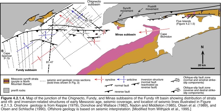 |
Figure 4.2.1.4. Map of the junction of the Chignecto,
Fundy, and Minas subbasins of the Fundy rift basin showing distribution
of strata and rift- and inversion-related structures of early Mesozoic
age, seismic coverage, and location of seismic lines illustrated in Figure
4.2.1.3. Onshore geology is from Keppie (1979), Donohoe and Wallace
(1982), Nadon and Middleton (1985), Olsen et al. (1989), and Olsen and
Schlische (1990). Offshore geology is based on seismic interpretation.
[Modified from Withjack et al., 1995.]
Click on the image at left for a larger version. |
Requirements for Basin Evolution and Tectonic Studies
The successful Newark Basin Coring Project (NBCP) has
demonstrated that it is possible to extract information on basin evolution
and tectonics from core data (see Section
3.3.2). Based on the results of NBCP, any potential coring target must
satisfy the following requirements: (1) long, continuous record; (2) availability
of information from both the depocenter and basin margins; (3) outcrop
control; (4) seismic coverage or potential for additional seismic coverage;
and (5) geographic accessibility. Based on the science questions
listed above, a coring target should also (1) contain known tectonostratigraphic
packages; (2) contain known inversion structures; (3) contain known CAMP
basalts; and (4) expand the geographic coverage beyond that of the NBCP.
 |
Figure 4.2.1.5. (a) Geologic map of the Five Islands region,
Minas subbasin of the Fundy rift basin. Arrows show only synrift sense
of movement on faults. (b) Cross section of Old Wife region showing partially
inverted down-to-the-northwest normal fault zone. Red box shows approximate
area of photo in (c), showing faulted contact between Blomidon red beds
and North Mountain Basalt. Triassic-Jurassic boundary is located a few
meters below contact. Photo is representative of spectacular shoreline
exposures in Fundy basin. (d) Cross section of Clarke Head-Wasson Bluff,
showing inversion-related folds and reverse faults. Note that the stratigraphy
of the pre-basalt formations is currently being revised. [Modified from
Olsen and Schlische (1990) and Withjack et al. (1995). Photo by R.W. Schlische.]
Click on the image at left for a larger version. |
Coring Targets
Based on the science questions and coring requirements
outlined above, we have identified two attractive coring targets.
Fundy Basin
The Fundy rift basin (Figures 4.2.1.1, 4.2.1.4) is located in New Brunswick and Nova Scotia, Canada. There are abundant coastal outcrops that provide evidence of multiple tectonostratigraphic (TS) packages. In addition to the Triassic-Jurassic boundary, the basin also contains a very thick post-CAMP basalt Early Jurassic-age stratigraphic section (Figure 4.2.1.5c), which is poorly known from outcrop studies and which will constrain when rifting ended in this basin. The Fundy rift basin also contains known post-CAMP inversion structures (Figures 4.2.1.3, 4.2.1.4, 4.2.1.5). Seismic data of variable quality are available from the Fundy basin (Figure 4.2.1.4). These seismic data also provide evidence of multiple tectonostratigraphic packages, extensional deformation, and post-CAMP inversion. Some of the seismic profiles can be reprocessed to overcome problems with multiples associated with the hard sea bottom and North Mountain Basalt. If necessary, new seismic data, including 3D seismic data, could be acquired. These seismic data would provide 3D information on basin geometry and its stratigraphic architecture, which would be helpful in siting the proposed core. Because of intense industry activity on the continental margin, the Fundy basin project offers the potential for industry partnership and ready access to the infrastructure needed for acquisition of new seismic data and coring.
The proposed core hole would be sited in the depocenter
of the basin and tied to one of two industry drill holes located near the
northwestern margin of the basin (e.g., Cape Spencer P-79 well in
Figure 4.2.1.4) along an existing or proposed seismic line. This
would allow us to determine variations in stratal thickness and facies
from the basin margins to the cored depocenter and would provide additional
constraints on basin geometry and depositional architecture, which are
necessary for basin-modeling studies.
The conjugate margin for the Fundy rift basin is
located in present-day Morocco. The Argana basin contains strata
very similar to those in the Fundy basin. Tectonostratigraphic packages
are also present in the Argana basin. Are these packages the same
age on both margins? Are the unconformities between the packages of broadly
similar ages? The Moroccan basins also contain a substantial postrift
section which potentially allows us to better constrain the age of the
inversion structures along this part of the margin. Both the Fundy
and Moroccan basins exhibit more arid facies than those found in the Newark
basin. This will allow us to explore latitudinal variation along
the rifted margin. In this more arid setting, sediment influx is not primarily
by moving water; there are important eolian and chemical inputs.

Click on the image above for a larger version. |
Figure 4.2.1.6. Simplified sketches showing Withjack et al.'s (1998) hypothesized tectonic evolution of eastern North America and northwestern Africa. (1) Supercontinental assembly was complete by Permian time (a). In Middle to Late Triassic time (b), all of eastern North America underwent NW-SE extension, manifested primarily in the formation and filling of half-graben basins. Prior to Early Jurassic time, the southern basins stopped subsiding. In earliest Jurassic time, the southern region experienced NW-SE shortening, resulting in the development of small-scale reverse faults, folds, and possible basin inversion as well as the intrusion of NW-striking diabase dikes; seafloor spreading began; coevally, the northern basins were actively extending in a NW-SE direction, resulting in the intrusion of NE-striking dikes and accelerated subsidence (c). By Middle Jurassic time, most of eastern North America was experiencing shortening, generally oriented NW-SE, which resulted in the development of small-scale reverse faults, folds, and basin inversion (d); seafloor spreading was now underway along most of the margin. [Modified from Withjack et al. (1998) and Schlische (2000).] |
Southeastern U. S.
The southeastern United States is the only place along the rifted margin where previous studies have postulated a direct connection between offshore SDR's and the onshore, but subsurface, Clubhouse Crossroads basalt via the J-reflector (see Figure 4.2.1.2c). This is also potentially the only place on the margin where the SDR's may be the same age as CAMP. If so, the volume of igneous material related to CAMP is enormous. Additional subsurface basalt flows extend as far west as Texas. Seismic data show that inversion structures affect the subsurface basalt flows (Figure 4.2.1.3g). The transect has two main objectives: (1) Drill through the Clubhouse Crossroads basalt, the underlying postrift strata, and any underlying synrift section. This will help put the Clubhouse Crossroads basalt in a proper stratigraphic architecture (Figure 4.2.1.3f). When did rifting begin and when did it terminate? When did inversion begin? (2) Core the SDR's in the offshore (as well as the overlying postrift section). By dating the Clubhouse Crossroads basalt and the SDR's, we can constrain the absolute and relative timing relationships among possibly multiple phases of igneous activity, the rift-drift transition, and the initiation of inversion.
The southeastern U.S. is also of interest because rifting
appears to have ended earlier and inversion began earlier here than in
the northeastern U.S. and southeastern Canada (Figure 4.2.1.6c, d).
Whereas the northeastern U.S. and southeastern Canada contain NE-striking
dikes of probable Early Jurassic age, the southeastern U.S. contains N-
and NW-striking dikes of probable Early Jurassic age (Figure 4.2.1.6c).
Are these N- and NW-striking dikes related to a change in the stress regime
from rifting to drifting? Or are they related to a complex stress
field resulting from the separation of Africa from North America and South
America from North America?
References
Austin, J. A., and seven others, 1990, Crustal structure of the Southeast Georgia embayment-Carolina trough: preliminary results of a composite seismic image of a continental suture(?) and a volcanic passive margin: Geology, v. 18, p. 1023-1027.
Behrendt, J. C., 1986, Structural interpretation of multichannel seismic reflection profiles crossing the southeastern United States and the adjacent continental margin--decollements, faults, Triassic (?) basins and Moho reflections, in Barszangi, M., and Brown, L., eds., Reflection Seismology, the Continental Crust: Washington, D. C., American Geophysical Union Geodynamic Series, v. 14, p. 201-214.
Benson, R. H., and Doyle, R. G., 1988, Early Mesozoic rift basins and the development of the United States middle Atlantic continental margin, in Manspeizer, W., ed., Triassic-Jurassic Rifting, Continental Breakup and the Origin of the Atlantic Ocean Passive Margins, Part A: New York, Elsevier, p. 99-127.
Costain, J. K., and Çoruh, C., 1989, Tectonic setting of Triassic half-grabens in the Appalachians: Seismic data acquisition, processing, and results, in Tankard, A. J., and Balkwill, H. R., eds., Extensional Tectonics and Stratigraphy of the North Atlantic Margins: American Association of Petroleum Geologists Memoir 46, p. 155-174.
Donohoe, H.V., and Wallace, P.I., 1982, Geologic map of the Cobequid Highlands, Colchester, Cumberland, and Pictou counties, Nova Scotia, scale 1:50,000, , Nova Scotia Department of Mines and Energy, Halifax, Nova Scotia.
Hamilton, R. M., Behrendt, J. C., and Ackermann, H. D., 1983, Land multichannel seismic-reflection evidence for tectonic features near Charleston, South Carolina, in Gohn, G. S., ed., Studies Related to the Charleston, South Carolina, Earthquake of 1886 Tectonics and Seismicity: Geological Survey Professional Paper 1313, p. I1-I18.
Keen, C. E., Kay, W. A., Keppie, J. D., Marillier, F., Pe-Piper, G., and Waldron, J. W. F., 1991a, Deep seismic reflection data from the Bay of Fundy and Gulf of Maine: Tectonic implications for the northern Appalachians: Canadian Journal of Earth Sciences, v. 28, p. 1096-1111.
Keen, C. E., Kay, W. A., and MacLean, B. C., 1991b, A deep seismic reflection profile across the Nova Scotia continental margin, offshore eastern Canada: Canadian Journal of Earth Sciences, v. 28, p. 1112-1120.
Keppie, J.D., ed., 1979, Geological map of Nova Scotia, scale 1:500,000, Nova Scotia Department of Mines and Energy, Halifax, Nova Scotia.
Klitgord, K. D., Hutchinson, D. R., and Schouten, H., 1988, U. S. Atlantic continental margin; structural and tectonic framework, in Sheridan, R. E., and Grow, J. A., eds., The Geology of North America, v. I-2, The Atlantic Continental Margin, U. S.: Geological Society of America, p. 19-56.
MacLean, B. C., and Wade, J. A., 1992, Petroleum geology of the continental margin south of the islands of St. Pierre and Miquelon, offshore Eastern Canada: Bulletin of Canadian Petroleum Geology, v. 40, p. 222-253.
Manspeizer, W., and Cousminer, H. L., 1988, Late Triassic-Early Jurassic synrift basins of the U. S. Atlantic margin, in Sheridan, R. E., and Grow, J. A., eds., The Geology of North America, v. I-2, The Atlantic Continental Margin, U. S.: Geological Society of America, p. 197-216.
Nadon, G.C., and Middleton, G.V., 1985, The stratigraphy and sedimentology of the Fundy Group (Triassic) of the St. Martins area, New Brunswick: Canadian Journal of Earth Sciences, v. 22, p. 1183-1203.
Oh, J., Austin, J. A., Phillips, J. D., Coffin, M. F., and Stoffa, P. L., 1995, Seward-dipping reflectors offshore the southeastern United States: Seismic evidence for extensive volcanism accompanying sequential formation of the Carolina trough and Blake Plateau basin: Geology, v. 23, p. 9-12.
Olsen, P. E., and Schlische, R. W., 1990, Transtensional arm of the early Mesozoic Fundy rift basin: Penecontemporaneous faulting and sedimentation: Geology, v. 18, p. 695-698.
Olsen, P. E., Schlische, R. W., and Gore, P. J. W., editors, 1989, Tectonic, depositional, and paleoecological history of early Mesozoic rift basins, eastern North America: International Geological Congress Field Trip T351, Washington, D. C., American Geophysical Union, 174 p.
Rankin, D. W., 1994, Continental margin of the eastern United States: Past and present, in Speed, R. C., ed., Phanerozoic Evolution of North American Continent-Ocean Transitions: Geological Society of America, DNAG Continent-Ocean Transect Volume, p. 129-218.
Schlische, R.W., 2000, Progress in understanding the structural geology, basin evolution, and tectonic history of the eastern North American rift system, in LeTourneau, P.M., and Olsen, P.E., eds., Aspects of Triassic-Jurassic Rift Basin Geoscience: New York, Columbia University Press, in press.
Shaler, N. S., and Woodworth, J. B., 1899, Geology of the Richmond basin, Virginia: U. S. Geological Survey Annual Report, No. 19, p. 1246-1263.
Shaler, N. S., and Woodworth, J. B., 1899, Geology of the Richmond basin, Virginia: U. S. Geological Survey Annual Report, No. 19, p. 1246-1263.
Tankard, A. J., and Welsink, H. J., 1989, Mesozoic extension and styles of basin formation in Atlantic Canada, in Tankard, A. J., and Balkwill, H. R., eds., Extensional Tectonics and Stratigraphy of the North Atlantic Margins: American Association of Petroleum Geologists Memoir 46, p. 175-195.
Withjack, M. O., Olsen, P. E., and Schlische, R. W., 1995, Tectonic evolution of the Fundy rift basin, Canada: Evidence of extension and shortening during passive margin development: Tectonics, v. 14, p. 390-405.
Withjack, M.O., Schlische, R.W., and Olsen, P.E., 1998, Diachronous
rifting, drifting, and inversion on the passive margin of central eastern
North America: An analog for other passive margins: AAPG Bulletin, v. 82,
p. 817-835.
| Previous |