A Closer Look
<-------- Image Dimension 185 km -------->
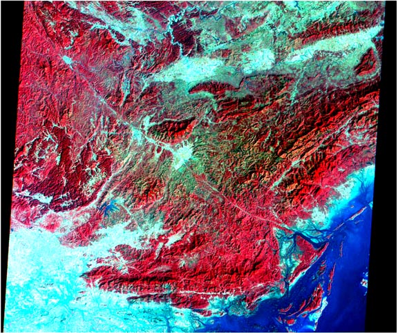
The Landsat image above shows a satellite view of the Red River Delta in northern Vietnam in 1986. Red areas indicate mature forest growing on rugged terrain at higher elevations. The lighter blue areas are marshes and cultivated land where paddy rice is grown. Dark blue areas are the deeper waters of Halong Bay. Hanoi is just off the lower left corner of the image. Satellite images like this have been collected for the past 25 years and provide an important means of quantifying the location and effects of human population growth on natural ecosystems.
Preliminary analyses indicate that there are significant regional variations as well as systematic consistencies with the global results presented here. It would be useful to stratify future analyses by rural versus urban residence and by tropical versus temperate latitudes, and to incorporate climatic variables (rainfall, temperature, and humidity), soil types, social, political and economic characteristics, and nonhuman biotic characteristics. Historical data would make it possible to examine whether correlations of population with variables conducive to agricultural production have changed with increasing global economic integration. Positive correlations of altitude with income in census tracts of New England cities (Meyer 1994) contrast with common reports that rich farmers take river valleys while poor farmers are forced to farm marginal mountain slopes in some developing countries. These patterns, as well as associations among geographic variables (such as being land-locked), rates of population growth, and rates of economic development in developing nations (Sachs 1997) provide hypotheses for further testing on a global scale with higher resolution data.
Our systematic description of the distribution of the human population
in relation to elevation illustrates an approach that can be applied to
spatially distributed natural hazards such as earthquakes, draughts and
floods. The approach alsso provides a quantitative basis for assessing the
human impact of potential environmental changes such as sea-level rise,
provided such analyses adequately incorporate the economic, cultural, political,
and other environmental factors that vary from place to place (Keyfitz 1992,
Cohen 1995). While a rich country might react defensively to sea-level rise
by building seawalls, such a response would be sub-optimal even from the
rich country's perspective if the same sea-level rise induced tens or hundreds
of millions of people to flee inundated low lands in a poor country and
to seek refuge in the rich country. The global approach taken here also
begins to establish a framework in which to place regional studies of sea-level
rise. It remains to use the present snapshot of the spatial distribution
of the human population as a basis for projections of the future.