Summary
Summary
The 1998 SCICEX scientific program, which had been revised consequent to delays earlier in the season, commenced on 1 August 1998 when the USN submarine Hawkbill entered the data release area in the Chukchi Sea. The scientific program commenced with a zonal water sampling transect that extended eastward roughly along the shelf break nearly to the mouth of Barrow Canyon. This was followed by a cross Arctic transect extending to the eastern extreme of the data release area. Expendable CTD probes were deployed at approximately 40 km intervals along this long transect. Interruptions allowed an ice survey of the SHEBA project area and a surfacing at the North Pole where bottom amphipod samples were obtained. The long transect was followed by an intensive swath mapping and hydrographic survey of the Arctic Mid-Ocean Ridge (AMOR). Immediately following, a southeastward transit to the Makarov Basin included hydrographic and swath mapping crossings of the AMOR and the Lomonosov Ridge. This transit was followed by occupation of four surface stations interspersed with an intensive hydrographic and swath mapping survey of the area associated with the Atlantic-Pacific frontal system along the northern flank of the Alpha-Mendeleyev Ridge. A final ice survey of the SHEBA area was then carried out, followed by an exit swath mapping and hydrographic survey of the western flank of the Chukchi Rise. Scientific operations concluded on 2 September when Hawkbill exited the data release area.
Scientific highlights included documentation of water flowing into the western Arctic Ocean, via the Makarov Basin, that was significantly warmer than in 1996. A major frontal system situated between the northern Nansen and Amundsen basins and associated with the Arctic Mid-Ocean Ridge was mapped for the first time. Water temperatures associated with this front exceeded 2?C, significantly higher than previously observed in the interior Arctic Ocean, and a strong current was present parallel to the front. To the west, in the Canadian Basin, the sub-ice upper ocean mixed layer was found to be unusually thin. Subsurface water temperatures remained high compared with historical values. Additional observations included crossings of the Lomonosov Ridge front and a detailed mapping of the frontal system, nearly 200 km in breadth, that was associated with the Alpha-Mendeleyev Ridge. Concurrently with the water column observations, SCICEX-98 for the first time used a swath mapper to carry out detailed surveys of the bottom topography associated with portions of the Arctic Mid-Ocean and Alpha-Mendeleyev ridges. Considerably more rugged topography, including steep slopes and peaks rising to within 1000 m of the sea surface, has been observed than is depicted on presently available charts. Simultaneous execution of the swath mapping and hydrographic surveys documented extremely strong topographic control over upper ocean hydrographic features.
Preface
This cruise report is intended primarily for the information of SCICEX investigators and agency personnel. It is not a formal report or publication. Its intent is instead to summarize the course of events during SCICEX-98, to provide some basic information that may aid in initial data processing, and to document specific events and quality control issues that arose during the operation. A small number of what we feel are significant results are presented in summary form. Finally a number of recommendations are made, based on the SCICEX-98 experience, for conduct of future SCICEX or other submarine-based scientific operations. It is assumed, since this document is planned for packaging on a CD-ROM with more detailed documentation of specific SCICEX-98 operations, that investigators with specific questions will refer to this detailed documentation. All information presented herein is preliminary, and should be treated as such.
The success of this cruise is in no small measure due to the extensive and enthusiastic support we received from Cdr. R.H. Perry, commanding officer USS Hawkbill, his officers and crew.
Robin Muench September 1998
Dale Chayes
Greg Kurras
Jay Ardai
Cover Graphic: Image derived from a digital photograph of Hawkbill surfaced at the North Pole on 9 August 1998 (courtesy of R. Beal).
Table of Contents
1 Introduction *
2 The Observational Program *
2.2 The Trans-Arctic Section *
2.3 SHEBA Survey & North Pole Activity *
2.4 Arctic Mid-Ocean Ridge Combined Survey *
2.5 AMOR and Lomonosov Ridge Sections *
2.6 Surface Oceanographic Stations *
2.7 Alpha-Mendeleyev Frontal Survey *
2.8 Second SHEBA Survey *
2.9 Western Chukchi Rise Survey *
3 Water Column Data Acquisition and Quality Control Issues *
3.1.1 Sail-Mounted CTDs *
3.1.2 Expendable Probes *
3.1.3 Lowered CTD *
3.2 Salinity *
3.3 Dissolved Oxygen Concentration *
3.4 Other Samples *
3.5 Other Considerations *
4 Selected Highlights *
4.2 Interannual Warming *
4.3 Changes in the Upper Mixed Layer *
5 Geophysics: *
5.1.1 Submarine Data Recording System (SDRS): *
5.1.2 Sidescan Swath Bathymetric Sonar (SSBS): *
5.1.3 High Resolution Subbottom Profiler (HRSP) *
5.1.4 Gravimeter *
5.1.5 Data Acquisition And Quality Control System (DAQCS): *
5.2 Geophysical Summary of SCICEX98 Arctic Survey *
5.2.1 Daily Logs *
5.3 Survey areas: *
5.3.1 Near Shelf Transits *
5.3.2 Gakkel Mid-Ocean Ridge Survey *
5.3.3 Buried Scarp Gravity Survey *
5.3.4 Chukchi Cap Survey *
5.3.5 Alpha-Mendeleyev Ridge Frontal Survey *
5.3.6 Cross-Basin Hydrographic Survey *
6 Comments and Recommendations *
6.2 Specific recommendations: *
7 APPENDIX A: Summary of SCICEX 98 Science Operations *
The SCICEX-98 deployment was fifth in a series of scientific field operations that have taken place in the Arctic Ocean using USN submarines as platforms. These operations have had both basic scientific and operational objectives, and have involved close cooperation between USN and civilian personnel in the planning and execution phases. This report addresses scientific aspects of the SCICEX-98 program.
The SCICEX-98 deployment had a number of scientific objectives. The primary ones were to continue documenting the physical, chemical and biological changes that are occurring in the Arctic Ocean and to initiate an ambitious program designed to characterize the topography and sediment distribution of the poorly documented Arctic Ocean floor. Documentation of physical, chemical and biological conditions was accomplished using a combination of underway instrumentation, inline sampling and deep oceanographic sampling conducted from the sea surface. Seafloor mapping was approached using a swath mapping system that had been installed on Hawkbill especially for this purpose. The water column studies focussed on documentation of conditions along a trans-Arctic section that has been occupied during several previous years and upon studies of water mass transitions or frontal zones associated with the Arctic Mid-Ocean, Lomonosov and Alpha-Mendeleyev Ridges. The swath mapping program focussed upon the very poorly defined northern portion of the Arctic Mid-Ocean Ridge, and supplemented the bathymetric information with underway sub-bottom and gravity data. Additional geophysical surveys were carried out over the central Alpha-Mendeleyev Ridge, coincident with the ocean frontal study, and less ambitious surveys were carried out of the western Chukchi Cap and a portion of seafloor just east of the southern Lomonosov Ridge.
The conduct of the observational program is summarily discussed below. The specific measurements are summarized and are discussed with respect to quality control issues where appropriate.
The SCICEX-98 scientific program commenced upon Hawkbillâs entry north of Bering Strait into the data release area [Figure 1 & Appendix A]. All underway instruments were activated and commenced measurement and recording of data. These instruments were to remain operating throughout the entire deployment. In addition to the recording instruments, a three-depth spiral cast was occupied each day during the period when the vessel carried out "housekeeping duties". Each short section of the following describes a separate phase or experiment, and each is followed by the dates of the activity as day of year (DOY).
The initial focussed operation was occupation of a transect eastward that roughly paralleled the shelf break north of the Chukchi Sea and terminated just west of Barrow Canyon. The purpose of this transect was to document upper ocean biological and chemical parameters within the context of inflow from the Bering Sea across the broad western Arctic shelves. The transect was anchored at each end by an eight-level spiral cast extending down to 232m. Water samples were taken from the through-hull fitting once per hour at depths between about 134 and 107 m, with the shallower depths being dictated by shallow bottom depths. Samples were taken at each site for salinity, dissolved oxygen concentration, nutrients, 18O concentration, barium and pigments. This latter suite of water samples was obtained from virtually every site where water samples were obtained, and will be referred to below as "routine" samples. Additional samples were taken at the spiral casts for 129I concentration and for microbiological analyses. (DOY 213-215)
 Figure 1. The SCICEX-98 cruise track superimposed on a chart showing bathymetry derived from ETOPO5. Green dots imbedded in the tracklines indicate one-day time intervals. Insets show detailed tracklines during each of four intensive surveys that were carried out during SCICEX-98. Red dots imbedded in the survey tracklines indicate one-hour time intervals. The bold black line indicates the boundary of the data release area.
The second operation was reoccupation of a cross-Arctic transect extending northward from the end of the near coastal transect, past the Pole, and on to the extreme southeastern boundary of the data release area. Repeat measurements along this transect are intended to allow large-scale documentation of the changes in water structure that have been occurring in the Arctic Ocean over the past decade. The measurements contribute to an ongoing program that is attempting to document long-term changes in the Arctic Ocean by measuring trans-Arctic acoustic propagation. To this end, expendable CTD probes were deployed about every 40 km along the transect. To provide additional documentation of upper ocean chemical and biological activity, water samples for later analyses were taken through the hull fitting at the time of every third probe launch. Vessel keel depth was maintained at 134 m, so that the samples were taken from 132 m. Parameters to be measured from the samples were the same as for the initial near-shelf transect. The initial flat bottom calibration runs for SCAMP were accomplished early in the transect. (DOY 215-223)
Two separate activities took place during diversions from the trans-Arctic section. The first of these was a detailed survey of sea ice and upper ocean conditions in the vicinity of the SHEBA ice station. The purpose of this survey, which was the first of two to be done in the same area during the summer, was to document sea ice conditions and changes over the course of the summer. The survey was carried out with vessel keel depth at 107 m, shallow relative to that used on other surveys, in order to provide adequate resolution of the ice cover. A small set of routine water samples was taken through the hull fitting, from a depth of 104 m, and a single xCTD probe was launched. (DOY 217-218)
The second activity was a one-day diversion during which Hawkbill surfaced at the North Pole. Although this activity was primarily for the benefit of ship personnel rather than for science, a very successful deep bottom cast for amphipods was carried out. These crustaceans will be analyzed for toxic substances and provide an effective means by which progress of substances such as pesticides can be traced in deep ocean waters. The first of three upper mixed layer surveys was carried out upon departure from the North Pole site and before resuming the trans-Arctic section. Keel depth was 58 m and Seacat sample depth was 42 m for this survey. (DOY 221)
Following completion of the trans-Arctic section, a combined SCAMP and water column survey was carried out over the northeastern Arctic Mid-Ocean Ridge (AMOR). SCAMP surveys include swath mapping, subbottom profiling and gravity measurements. The purpose of the SCAMP survey was to investigate the geophysical structure of the Ridge that is part of the slowest ocean floor spreading center on earth. The revised SCAMP plan was designed to fill in information gaps between AMOR surveys conducted during earlier SCICEX deployments. Geophysical survey issues are discussed further in Section 4. Concurrently with the geophysical work, a detailed hydrographic and water chemistry survey was carried out of the frontal structure overlying the Ridge. The survey was carried out at using a keel depth of 229 m, which provided routine water samples from 226 m and underway recorded T, S and dissolved oxygen concentration from 212 m. This was a highly effective survey depth for this region of the Arctic Ocean because it allowed measurements nearly down to the warm core of Atlantic-derived water. The second and third of three upper mixed layer surveys were conducted during this operation, with keel depth at 58 m for a sail-mounted Seacat sampling depth of 42 m. (DOY 223-229)
It had been planned to transit directly from the endpoint of the AMOR survey to the location of the first surface station, 4-1. A number of additional xCTD probes had been made available for use because of deletion of the "Spinnaker" portion of the trans-Arctic survey. This transit provided an opportunity to utilize the extra probes in making detailed transects farther south across the AMOR and across the Lomonosov Ridge. Probe spacing was 18.5 km during the surveys, and a keel depth of 229 m was maintained both to allow sampling in the upper portion of the warm water strata and to provide higher quality geophysical data. The Lomonosov Ridge transect coincided with one occupied by the German vessel Polarstern in summer 1996, and will allow comparison and assessment of time change. The data will also be sufficient to allow comparison with conditions farther north where the trans-Arctic section crossed over the Ridge. (DOY 230-231)
Four surfacings were made for the purpose of carrying out water sampling and CTD profile measurements down to a depth of 1600 m. Each surfacing had a number of casts, with the intention of obtaining samples from 20 depths per station down to a depth of 1600 m. The first cast at each site was the deepest and carried a SeaBird SBE-25 CTD profiler on the bottom of the hydro line. The second cast was a shallow cast in order to provide a "breather" for personnel standing in the weather. The third cast was nominally to 550 m and included a profiling acoustic Doppler current profiler (ADCP) that was suspended directly from the CTD in downward-looking mode. Additional casts were carried out at some sites in order to obtain special samples such as those for 137Cs or lignins. Surface samples were obtained using a bucket, and 10 m samples were obtained from the through-hull sampling system which provided actual sample depths closer to 8 than to 10 m. All cast samples were obtained using 12 liter Niskin bottles that were isolated from the vesselâs internal atmosphere during transit. Samples were drawn from the Niskins in a heated, fabric enclosure situated aft of the sail and directly adjacent to the gantry and winch used to make the casts.
The first surface station, 4-1, directly followed completion of the combined AMOR and Lomonosov Ridge transect. Hawkbill surfaced in a very large, irregular lead surrounded by multi-year pack ice. All planned operations, including a single deep cast to obtain large volume samples for 137Cs and 129I analyses, were successfully completed. In addition to standard samples, water samples for helium, tritium and CFC analyses were obtained at all depths. (DOY 232)
The second science surfacing, 4-2, took place following a transect from site 4-1 during which a sawtooth swath mapping survey was carried out in search of a possible bottom escarpment associated with the Lomonosov Ridge. Hawkbill surfaced, as before, in a very large, irregular lead. Winds during this operation were estimated on the basis of ice drift speed to be about 25 knots (see below discussion under "Other Considerations"). The resulting wire angles and vessel maneuvering in order to avoid ice made it impossible to obtain samples deeper than about 600 m. Specific problems are discussed further in Section 3.5. Standard samples, helium, tritium and CFCs were obtained at all depths sampled. (DOY 233)
The third surfacing, 4-3, also took place in a large lead. Unlike the previous two surfacings, wind speed was virtually zero. A complete set of samples to depth including standard samples, heliums, tritiums, CFCs and large-volume lignins was taken. Additionally, the second of two bottom amphipod traps was put out, returning a single specimen that was discovered only weeks later at cruise end. (DOY 237-238)
The final surfacing, 4-4, also took place in a large lead with very light winds. Samples were successfully obtained from all depths. (DOY 241)
An intensive hydrographic and water chemistry survey of the Atlantic-Pacific frontal zone along the northern flank of the central Alpha-Mendeleyev Ridge was carried out. Surface station 4-3 was imbedded within the frontal survey, and provided deep samples on the Atlantic side of the front. Initially conceived of as a linear feature estimated to be 50 km or so in width, the front proved instead to be a complex frontal system more than 150 km wide and having a complex configuration. This complexity was apparently abetted by steep bottom topography, resulting in isolated warm, eddy-like features. Most of the survey was carried out at a keel depth of 229 m, because this provided a reasonable identification of water masses based on temperature than was possible at shallower depths. Salinity at shallower depths responded strongly to mesoscale differences in pycnocline depth, and did not appear to be useful for frontal identification over the scales involved. Horizontal salinity differences measured by the sail-mounted Seacats over mesoscales resulted from vertical displacement of the halocline as much as from horizontal change. (DOY 234-239)
A second upper ocean and ice survey was conducted in the vicinity of the SHEBA ice camp. As for the previous survey, underway keel depth was 107 m. This second survey was displaced north from the earlier one in order to follow the same patch of ice, which had drifted northward. The first and second surveys combine to form a complete survey of the SHEBA ice area. These surveys are revised from the original plan consequent to the shortened field operation. The final surface station, 4-4, was imbedded in this survey and provided more detailed upper ocean information than would otherwise have been available. (DOY 240-243)
Nearing the end of the operation, additional time was made available for science operations as a result of lower than planned use of housekeeping and contingency time. This time was used to conduct a modest sawtooth pattern hydrographic and seafloor swath mapping survey along the western slope of the Chukchi Rise. A second and final flat-bottom calibration run was made for the swath mapper during the course of this operation, as was a backscatter calibration run for the hull mounted acoustic Doppler current profiler. At the completion of these operations a final 8-depth spiral cast and xCTD probe launch were done before exiting the data release area early on 2 September. (DOY 243-244)
Seawater temperature data were obtained using three separate types of instruments. Temperature was continuously measured while underway by a pair of Seabird Seacat SBE 19 CTD (conductivity, temperature, depth) systems mounted in the upper sail about 16 m above vessel keel depth as shown in Figure 16. Sample input was through short lengths of tubing attached to fittings that allowed access to water outside the sail. Sample output was through separate tubing. Flow through the sensors is pumped.
Each of the two Seacats was powered by a source situated in the laboratory space inside Hawkbill, eliminating concerns with battery life. Data were recorded on a pair of laptop PCs using SeaSoft, and were backed up on at least a daily basis. Data quality was continuously monitored visually on the laptop displays. Temperature and oxygen readings from both Seacats fluctuated when the vessel maneuvered rapidly. The Seacat designated as #2 stabilized quickly following these incidents, whereas that designated as #1 required as long as 15-20 minutes to completely recover. The reasons for this are unclear, but may have been related to the flow rates through the tubing connecting the two instruments with the outside water source. A temperature comparison between Seacats #1 and 2 showed agreement to within 0.01?C during periods when readings were stable. Because of the apparently shorter time constant of Seacat #2, this unit was used for the preliminary comparisons reported here.
The two Seacats were calibrated by Seabird prior to the deployment, and will be recalibrated directly following the deployment. Temperatures from the two instruments generally agreed to within a few hundredths of a degree C. Significant disagreement occurred only in regions of very strong gradients and when the vessel was rapidly maneuvering. It is suspected that these differences resulted at least in part from lag time differences associated with the tubing and connections leading to and exiting from the two instruments. It is further suspected that dynamic pressure influences associated with the sail and with use of the fairwater planes influenced sample lag times by affecting through flow rates to the instruments.
Figure 2 : Ensemble of all vertical temperature profiles obtained using xCTDs during SCICEX-98. Data shown here are uncorrected except for filtering through an 8th order, 20 m lowpass Butterworth filter to remove high frequency noise that was present on many of the traces. Gaps in the data marked as "F" denote frontal regions, and the three major water masses present in the Arctic Ocean are identified by name. Additionally, the profiles clearly show the inversions, related to mixing and frontal processes, present in the temperature maximum strata.
Vertical temperature profiles were measured using Sippican expendable UISSXCTD probes. Of 159 probes deployed, 146 (92%) returned valid data as determined by visual inspection immediately following the probe launches. Nominal maximum trace depth was 1000 m. Probes were pre-calibrated by the manufacturer. Documentation was not available aboard ship, however, the informal consensus was that temperatures were advertised as accurate to 0.02?C and salinity to better than 0.1 PSU. Field checks on accuracy were carried out through comparison with temperatures measured by the sail-mounted Seacats at the times of probe launch. Deep water temperature measured by the probes provided an additional field check, since water at 1000 m depth in the Arctic Ocean generally varies by less than the probe accuracy limits over the relatively small horizontal distances between probe launches. Preliminary consideration of these validity checks suggests that the probes were generally accurate to within the above limits. Some individual traces were clearly affected by offsets in temperature, and these will be dealt with during post-cruise processing. Some traces were afflicted with high-frequency noise that in cases exceeded the advertised accuracy. Preliminary attempts at filtering these data and comparing the filtered profiles with Seacat results suggest that the noise can be removed and that the smoothed profile falls within the advertised accuracy. A useful preliminary check on data quality can be performed by overlaying all profile plots of temperature and salinity versus depth and temperature as a function of salinity [Figures 2-4]. Bad data show clearly as flyers in these plots. The plots are useful, additionally, for identifying ocean features such as fronts.
Additional checks on probe temperature profiles are available at each of the four surface stations in the form of vertical profiles from the Seabird SBE-25 CTD. Probes were launched at the surface sites directly following completion of the surface station activities.
Finally, temperature was measured as vertical profiles at each of the four surface stations using an internally recording Seabird SBE-25 CTD system. Like the sail-mounted Seacats, this unit was factory calibrated prior to the deployment and will be recalibrated immediately afterward. Advertised accuracy of the system is better than 0.01?C. The unit provided a useable profile for each of the two casts on each station for which it was used. Other than a small number of errors encountered in downloading the data from the unit to a laptop PC following each cast for an immediate quality check, no problems were encountered that would have impacted data quality in significant fashion. Despite these preliminary conclusions, concern remains that modifications made to the unit that included removal of the pump from the T and S sensors likely impacted sensor time response. Additional processing will address this possible impact.
Salinity was calculated from conductivity measured using the same three systems described above for temperature, the sail-mounted Seacats, expendable CTDs and a profiling SeaBird CTD used during the surface casts. In addition, salinity was determined for water samples obtained at more than 300 sites. These samples were obtained both as through-hull samples from 2.5m above keel depth and as samples obtained from each of the Niskin bottles deployed on the surface casts. The samples were allowed to come to thermal equilibrium in the laboratory space, where ambient temperatures rarely differed greatly from 22-24?C. They were then analyzed for salinity using a benchtop Guildline model 8410 Portasal© salinometer. The internal bath in the salinometer was maintained at 24?C, so minimal time was needed for thermal equilibrium. Salinity samples were run in batches generally consisting of 2-3 dozen. Calibration was performed using fresh standard water before and following each run. Dual analyses were run for each sample. Replication between dual runs was usually better than 0.01 PSU and frequently was of order 0.001 PSU. If the discrepancy was greater or if other questions arose, a third analysis was run for that sample. Final values for bottle salinities are conservatively estimated to be better than 0.01 PSU in accuracy.
 Figure 3. Ensemble plot of all salinity profiles obtained using xCTDs during SCICEX, processed as for Figure 2 and identifying the same features.
Salinity values obtained from samples are plotted as a function of sequential sample number [Figure 5]. Salinities measured by sail-mounted Seacat #2 are plotted on the same scale to allow comparison. The lowest and highest sequential numbers represent samples from the western Arctic, generally west of the Alpha-Mendeleyev Ridge, while the mid-range numbers represent samples from east of the Ridge. Salinities were lower west of the Ridge than to its east, and vertical stratification was greater as shown by the differences between samples acquired from different depths. The highest salinities represent samples obtained from 226m, the greatest depth regularly sampled from the through-hull port. The lowest salinity values were measured from near-surface samples obtained during the surface stations. The significant scatter between many pairs of samples illustrates difficulties, discussed below, in comparing parameter values derived from different sources and depths.
Dissolved oxygen concentration was measured by both of the sail-mounted Seacats, by the SeaBird SBE-25 CTD used during the four surface stations, and by onboard titration of water samples obtained for the purpose at virtually all sample sites as part of the standard sampling suite. Titrations were run using a semi-automated system based on a 665 Dosimat that was obtained for the purpose from Oregon State University. A comparison between all oxygen concentrations derived from bottle samples and those measured at the times of sample collection by Seacat #2 shows a consistent offset of order 0.3 ml/l for a persistent band of samples through the central part of the program [Figure 6]. The Seacat provided the lower value. This band coincided with the samples collected when keel depth was 232 m and vertical gradients in dissolved oxygen concentration were lowest. Extremely high values were encountered in the uppermost layers and especially during surface casts, and the highest values were obtained from surface bucket samples at the surface sites. Seacat #1 also recorded dissolved oxygen concentrations, but the record was extremely noisy and values tended to be in excess of 1 ml/l lower than measured by Seacat #2. While Seacat #1 values were recorded on the raw log sheets, they are not carried into the final log and are not shown here. This unusual pattern was observed during sea trials, but replacement of both the oxygen sensor and the pump failed to cure the problem, and questions remain.
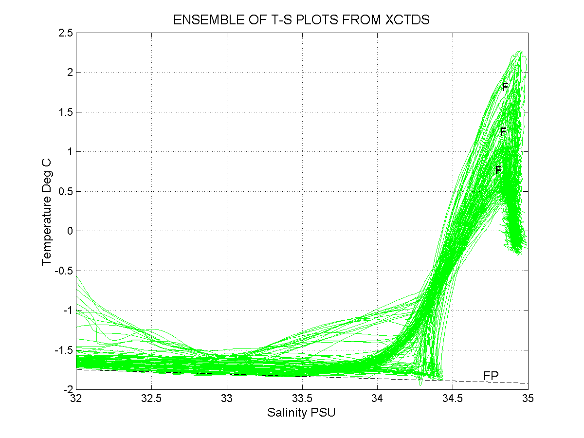 Figure 4: Ensemble of all temperature-salinity plots derived from xCTD data during SCICEX-98, processed as for Figures 2 and 3. Three separate frontal regions are identifiable, and appear on casual inspection to correspond to the AMOR, Lomonosov and Alpha-Mendeleyev Ridge systems. The dashed line labeled "FP" shows freezing point as a function of salinity and provides an additional check on data validity. Encouragingly, minimum temperatures fall nearly at the freezing point as expected.
Other water samples were obtained following standard sampling procedures and the sampling protocol provided for specific samples by some investigators. CFC samples were flame sealed in ampoules on the open deck. Proximity to luminous watch dials was avoided during any procedures involving handling of tritium samples. Samples for nutrient analysis were placed into freezers as soon as possible, and often within less than a minute, following drawing of samples. Sample bottle numbers were logged prior to each operation and were checked again before stowing the samples. An "Event and Sample" log sheet was maintained throughout the operation and was updated daily. At the conclusion of operations all logged samples were checked against numbers of samples drawn. It was possible to resolve most of the very few discrepancies that were discovered. The few unresolved discrepancies are noted on the log sheet and will likely be resolved once analyses have been run and the resulting numbers can be examined in a context with the other data. Finally, the two sail-mounted Seacats were equipped with a fluorometer and transmissometer. The fluorometer was not displayed in real-time but was recorded the whole time. It may be useful with suitable post-processing to help suppress excessive noise in the data which may come from entrained bubbles. The transmissometer appears upon visual inspection of the real-time traces to have worked throughout the deployment.

 Figure 5: Salinities in PSU derived from sail-mounted Seacat #2 and from bottle samples, plotted as a function of Sequential Sample Number.
Data problems can result in the polar regions from freezing of sensors when they are exposed to low ambient air temperatures. Such freezing can ice up conductivity cells, leading to erroneous low salinity readings, can clog circulating pumps, and can destroy dissolved oxygen concentration sensors. Freezing of samples obtained in bottles such as the Niskin bottles used during surface casts increases the concentration of dissolved materials in the remaining liquid seawater, leading to erroneous values for chemical analyses carried out on the samples. Hawkbill surfaced four times for the surface oceanographic stations, and several additional times for various reasons. At no time during these surfacings was air temperature sufficiently low to cause freezing problems in sensors or in water sample bottles. Temperatures were generally at or slightly above the freezing point. Provision of a heated enclosure for drawing samples from the Niskin bottles provided insurance against inadvertent freezing of any of the samples. As a result of the mild conditions and these precautions, no freezing problems were encountered.
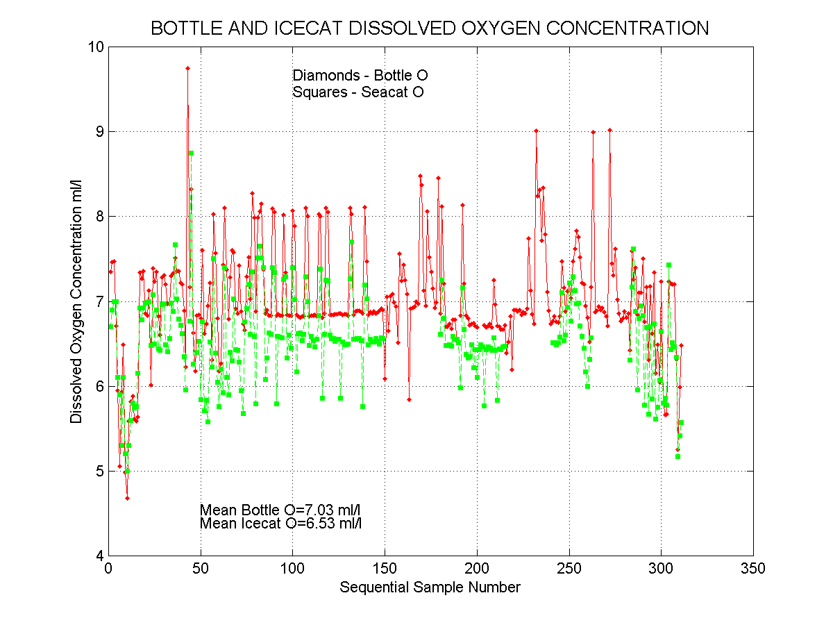 Figure 6: Dissolved oxygen concentration in ml/l plotted as a function of sequential sample number. Values were obtained from titration of bottle samples 2.5 m above keel depth and from Seacat #2 measurements 16 m above the keel.
Intercomparison of parameter values measured using different instruments or based on samples from different sources must be approached with caution. The two Seacats were mounted near the top of the sail about 12.5m above keel depth. A significant, if undetermined, lag was present between passage through a parameter change and its measurement. Further, the two instruments appeared on occasion to have slightly different flushing rates and correspondingly different lag times. Through-hull samples were obtained, unlike water measured by the Seacats, via an inlet only about 2.5m above keel depth. This line was well flushed by letting water flow at a high rate for several minutes prior to drawing the sample. However, the "standard" underway sampling depths of 104m, 132m and 226m all fall within the strong vertical parameter gradients associated with the Arctic Ocean thermocline and halocline. Any comparison between Seacat and through-hull sample derived salinity or dissolved oxygen concentrations will reflect the vertical stratification over the 10m increment between effective sampling depths. This varies from site to site and was significantly greater in the western than in the eastern Arctic. This can be seen in the pattern of discrepancies between Seacat and bottle-derived salinities and dissolved oxygen concentrations [Figures 5 and 6]. For the surface stations, imperfect flushing of the Niskin bottles can result in non-representative samples through strong vertical gradients. In general, those samples obtained through the hull fitting are likely, because of the complete flushing achieved, to provide the most representative values in the regions of strong vertical gradient within which we were usually sampling.
The method employed during surface stations was for Hawkbill to surface in a very large lead and hold position away from the peripheral ice while conducting sampling. This worked very well in conditions of low wind speeds. When wind speeds were higher, however, drift rates resulted in unacceptably high line angles as the CTD and sample bottles were dragged aft by the forward relative drift of the vessel and surrounding ice. At one of the surface stations (4-2) these drift speeds approached 0.5ms-1. The resulting line angle was estimated at 45? and was adequate to prevent the messenger from tripping one of the bottles. In addition, the line angle caused the line to trend beneath the hull and required additional maneuvering. No method was available by which to measure wind speed, but given the measured drift rate and assuming ice drifting at 4% of the wind speed for an essentially free drift situation as was observed at the site, it likely was of order 12ms-1. These conditions prevented our sampling to depths greater than about 600 m.
Preliminary checking of the data for purposes of field validation resulted in some interesting discoveries. A few of these are presented here to help stimulate follow-on activity.
A detailed underway survey was made of the region overlying the northern Arctic Mid-Ocean Ridge as an adjunct to the swath mapping survey. This survey mapped a strong frontal system that was associated with the Arctic Mid-Ocean Ridge. Two crossings were made of this frontal system during which xCTD probes were launched at regular intervals. The first crossing occurred during occupation of the trans-Arctic section, with xCTD probe launches every 40 km and continuous underway T, S and dissolved oxygen concentration recording by the sail-mounted Seacats. The second crossing took place travelling in the opposite direction about 200 km farther south. xCTD probes were launched at 19 km intervals during this second crossing, which occurred at an angle to the front so that cross-frontal probe spacing was less than 19 km. Parameter mapping using underway data from the Seacats showed a strong parallelism between the front and the Ridge. Navigation data showed a persistent, significant current paralleling the front. This current was southeastward near the Ridge crest and some 50 km in width.
The strong temperature gradient across the front can be seen by comparing the vertical profiles of temperature that were obtained using xCTD probes during xCTD transits across the front [Figure 7]. The probes were evenly spaced along each of the transits. The traces from the much more closely spaced probes on the southern transit suggest a central band of lower horizontal temperature gradient bounded on either side by regions of stronger gradient. This would be consistent with a filamentous frontal structure. The profiles also show presence of the large temperature inversions that are associated with the warm core, that have been observed throughout much of the Arctic Ocean, and that are of uncertain origin and significance.
Documentation of interannual change is a primary objective of the SCICEX program. In general, the warm conditions that have been documented in the Arctic Ocean were observed to have persisted to the present time. Rigorous assessment of change will require a greater effort than is possible here. It is possible, however, to present an illustrative case. Surface station 4-1 coincided almost exactly in geographical position, however, with a full depth oceanographic cast taken by the German icebreaker Polarstern in August 1996. Core temperatures at this site were significantly higher during SCICEX than in 1996 [Figure 8]. Salinity beneath the upper layer was nearly the same for both years, allowing for the estimated 0.1 PSU uncertainty in xCTD salinity values. More rigorous comparison with the SBE-25 CTD trace from the site will provide a more accurate assessment of salinity change. The SCICEX-98 data from this site are robust, consisting of two virtually identical xCTD probe traces and two profiles made using a SeaBird SBE-25 CTD. The Polarstern occupied a second station at nearly the same location as that shown, also, and the resulting trace was identical to that shown. This site is within the slope current that flows eastward in the Makarov Basin, and an increased water column heat content here would mean that more heat is being supplied than previously to the western Arctic Ocean including the Makarov and Canadian basins.
 Figure 7: Vertical temperature profiles measured along two transits across the Arctic Mid-Ocean Ridge frontal system using xCTD probes. The blue traces represent temperature conditions in the Amundsen Basin, while the red traces represent the Nansen Basin. Remaining traces document the intervening frontal structure. See the text for additional discussion.
Recent oceanographic research in the Arctic, and in particular that carried out from the SHEBA ice station over the past year, has revealed a thinning of the upper mixed layer. Results from SCICEX-98 were consistent with this trend. Measurements were obtained through the surface mixed layer at the four surface stations and at several additional sites, such as that at the North Pole, where Hawkbill surfaced for non-scientific reasons. In the western region, which included the SHEBA site, the mixed layer was of order 20 meters thick or less. This was not true of the eastern regions including the Amundsen and Nansen basins, where mixed layer depth typically exceeded 40 m [see the T profiles shown in Figure 7]. Three upper mixed layer studies were conducted in the latter region. The very thin mixed layer, coupled with the presence of deep ice keels that prevented underway operations in keel depths of less than 58 m, placing the intakes for the Seacats at a depth of 42 m. (The maximum keel depth logged during SCICEX-98 was 34 m.)
 Figure 8: Temperature and salinity profiles obtained at almost precisely the same location near the 1800 m isobath along the southern Makarov Basin continental slope. The 1996 profile was obtained in August 1966 by the German icebreaker Polarstern and the 1998 profiles were obtained by Hawkbill during SCICEX-98.
The SCICEX98 cruise on the Hawkbill was a successful first deployment for the Seafloor Characterization and Mapping Pods (SCAMP). SCAMP instrumentation is discussed in section 5.1 (Geophysical Instrumentation) and the various surveys are addressed in section 5.2 (Geophysical Summary). The SCAMP subsystems recorded good to excellent quality data continuously for the duration (just over 31 days) of the data acquisition portion of the cruise. The two sonars (HRSP and SSBS) were put in standby during surfacings. Routine quality control checking was performed on a daily basis.
The SCAMP system consists of two active sonars and a marine gravity meter integrated with a data system to support the real-time operation of the instruments, to log the data (and metadata) and to provide on-board quality control and display capabilities. The sonars include a swept frequency (Îchirpâ) subbottom profiler and swath sidescan and bathymetric mapping sonar. The transducer arrays the sonars are mounted in pods bolted to the keel of the submarine as show in Figure 9. The SCAMP installation and design details are documented elsewhere.

Figure 10: Location of the Sidescan Swath Bathymetric Sonar (SSBS) and High Resolution Subbottom Profiler pods on the keel of the USS Hawkbill during SCICEX98.
The Submarine Data Recording System (SDRS) is a standard part of the SCICEX installation. It provides the interface to the submarineâs own data including position, depth, speed, heading, and attitude. SDRS records the data on quarter-inch QIC cartridge tape and provides a real-time data stream to DAQCS via an asynchronous serial connection.
As is typical with each SDRS installation, there were some ship-specific adjustments but these were accomplished prior to arrival in the data collection area. Careful attention to validating the SDRS data stream must continue to be part of the installation and shakedown for each SCICEX cruise.
During one of the initial attempts to get into the data box, the SDRS electronics developed a power supply problem. The unit was replaced during the last stop in Pearl Harbor in late July.
In the SCICEX installation, the Digital Ice Profiling system (DIPS) shares some of the synchro signals used by SDRS. During the installation, a problem was identified with one of the DIPS cables. During the cruise, the DIPS-III developed problems and was replaced with itâs backup (a DIPS-II.) During this exchange, the bad cable was inadvertently re-installed. This resulted in a short circuit which caused a blown fuse in one of the SDRS synchro buffer units. A data gap on the order of an hour resulted from this error. Other than the blown fuses the SDRS was a reasonably reliable source of real-time data for SCAMP.
The SSBS is a bilateral swath mapping sonar that operates at 12 kilohertz at ping intervals out to 20 seconds. Multiple rows of receive elements allow the phase of return signals to be estimated and eventually converted into swath bathymetry in addition to producing high quality seafloor images.
The SSBS is a SeaMARCÔ adapted for use on submarines and particularly under the ice canopy of the arctic. These adaptations are particularly evident in the transducer arrays and in the packaging. The arrays are designed to allow transmit and receive beam steering in order to produce a notch in the receive beam pattern intended to suppress return energy from features (such as pressure ridges and open water edges) in the ice canopy. Packaging adaptations include mounting the electronics outboard under the fore deck and various accommodations in the data system to allow it to fit into the available space in the Torpedo Room.
The SSBS electronics were designed by Raytheon Systems Corporation (RSC), formerly Alliant TechSystems in collaboration with the SCAMP team (Lamont-Doherty, SOEST, and the Arctic Submarine Lab.)
The SSBS is controlled through a graphical user interface implemented under Motif/X11 and running on a Sun Ultra SPARC-2 multiprocessor provided with the sonar by RSC. This application provides real-time sidescan image and operational parameter displays, and logs the SSBS data to disk. The SSBS produces about 9 gigabytes of data per day. This data is checked and then archived to DLT tape.

Figure 11: Block diagram of the SCAMP system as installed on the Hawkbill for SCICEX0
This was the first SSBS deployment and there were a number of teething problems to overcome. These included telemetry problems, heat distribution problems and difficulties with the starboard transmitter. During the cruise a problem developed with extraneous noise in the port upper channel, and a low signal strength problem was diagnosed in the starboard upper channel. In spite of these obstacles, the total down-time was on the order of 3% while underway in the data release area.
Preliminary evaluation of the SSBS data indicates that sidescan image and electrical phase data is typically available out well past the first bottom multiple on the port side but significantly less on the starboard side. We were able to work out a method to display the sidescan (image) data but work remains on that front as well. Due to unanticipated and not yet fully understood details of the SSBS performance, we were not able to routinely extract bathymetry from the electrical phase difference data using the available software. However, exploratory analysis of the phase data suggests that the inherent data quality is good and should result in good quality bathymetric and image data in time.
As initially installed, the telemetry system simply could not support the system requirements over the available cables and electrical hull fittings. This was a serious deficiency in the design and one that took a significant effort to overcome. The last minute, temporary fix was to provide an in-line re-transmitter (the Telemetry Translator Unit or TTU) near the electrical hull fitting in the Control Room. This was designed, built from telemetry spares and tested just prior to the initial departure from Pearl Harbor in early June.
A second serious problem raised itâs ugly head early on in the remedial testing which caused the system to fail and require substantial periods of time to recover. The characteristics of this problem suggested a thermal problem in the outboard electronics. During our various repair efforts (including extensive thermal surveys of the electronics) we found that by carefully re-routing the cable harnesses in the Control Electronics pressure case we were able to eliminate this problem.
Results from the brief at-sea test that we were able accomplish prior to the initial departure from Pearl Harbor indicated that the starboard side transmitter was not delivering adequate energy into the water. We were fortunate to be able to take advantage of the port stop in Bangor in late June to get the transmitter working again and briefly tested during the second attempt to get to the data release area.
We were again allowed to do limited testing and this indicated that the starboard side was still not performing as expected. Yet another round of dockside testing was done during the repair period in Pearl Harbor in late July. Due to the quick repair of SINS we did not have time to dig deep enough to make further improvements, but we were able to clarify a number questions and eliminate some potential sources of error, and get the starboard transmitter working.
The boat was very accommodating in allowing various engineering tests and it is largely due to these opportunities that we were able to make the repairs and improvements that resulted in getting good SSBS data.
The SCAMP subbottom profiler is an ODEC Bathy-2000P with significant modifications for submarine operation and integration with the SCAMP data system. It is a frequency modulated sounder operating between 2,750 and 6,750 kilohertz with transmit sweep lengths of up to 50 milliseconds.
All of the HRSP electronics are installed in shallow 19" EIA racks mounted on skid-plates in the Torpedo Room. As provided by ODEC, the single HRSP chassis was too deep to meet the requirements of skid-plate mounting. In order to accommodate installation of the electronics were re-packages at Lamont into two shallow chassis while preserving the original display as well as the front and rear panels.
The HRSP as configured for the SCAMP installation take a number of data streams from the DAQCS in real-time via asynchronous serial interfaces including time, position and keel depth. It provides limited real-time data (including status and water depth) via asynchronous serial interfaces. The digital data representing the match filtered bottom penetrating time series is transferred to DAQCS via a real-time Ethernet connection.
Although the HRSP has a number of sometimes irritating behavioral quirks it ran for long periods of time with little or no operator intervention. It routinely produced very high quality subbottom data often with penetration in excess of 100 meters (at 1500 m/s sound speed) and on occasion penetration in excess of 200 meters!
The significant areas of concern include better tuning of the bottom-tracking filter to accommodate the high survey speeds that can be achieved with the submarine and some details of the real-time data record format. These issues will be addressed with ODEC and we expect that many if not all will be resolved in time for the next deployment.
As in all of the precious submarine science cruises in the SCICEX program, a Bell Aerospace BGM-3 gravity meter (SN: 207) was installed on skid plates in the Torpedo room per the TEMPALT. An LDEO Gravity Meter Interface converts the output of the gravity meter to serial data that is time-stamped and logged by DAQCS.
Pre-cruise gravity ties were done in Pearl Harbor in April and July. A post cruise tie will be done in Pearl Harbor in September.
The BGM-3 requires very little operator attention other than routine monitoring. Daily checks were performed on the instrument and on the data.
On previous field program (aerogeophysical operations in Antarctica) the output from this meter was reported to have taken temporary offsets on the order of 13%. Substantial testing of the meter prior to installation and during the trials and initial attempts to get into the data release area did not show any indication of this behavior. However, several such offsets occurred during the data acquisition period. Initial evaluation of the data indicates that these are simply DC-offsets can should not present insurmountable problems for post processing. However, the source of this offset remains unknown and somewhat worrisome for the long term.
The Data Acquisition and Quality Control System is a Unix-based multi-processor data system configured for installation in the limited space available. The design is based on the proven systems used by LDEO on the RV Conrad and the RV Ewing (going back to 1985) and the RVIB Nathaniel B. Palmer.
For this field program, DAQCS logged the data from the Sidescan Swath Bathymetric Sonar, the High Resolution Subbottom Profiler, the Submarine Data Recording System, the #2 sail-mounted CTD, the BGM-3, and an electrostatic pitch and roll sensor (for roll correction of the SSBS swath mapping data.)
DAQCS' primary roles are to provide the real-time data logging and routine data quality checking for the SCAMP instruments. In addition, DAQCS provided the resources for a number of software development and data analysis efforts during the cruise. These included:

Figure 12: The USS Hawkbill SCICEX98 Arctic Ocean survey trackline (01 Aug - 01 Sep '98). Bathymetry & topography are from the ETOPO5 database.
The 1998 SCICEX cruise onboard the USS Hawkbill spent 31 days from August 01 - September 01 conducting Oceanographic and Geophysical surveys throughout the Arctic Ocean.
Gravity, sidescan, swath bathymetry, and chirp sub-bottom data were collected by the SCAMP (Seafloor Characterization And Mapping Pods) system to study and better define the geology of the Arctic basin. The focuses of these data sets were a near-shelf transit, a cross-basin transit, the Gakkel Mid-Ocean Ridge, a buried fault scarp, the Alpha-Mendeleyev Ridge, and the Chukchi Cap. The following sections provide brief summaries of each region and preliminary comments on the data collected. Navigational data has been filtered to remove spikes but it has not been corrected. Corrected navigation will be available after declassification and post-processing of SDRS data. Gravity data has been examined only in raw form uncorrected for depth variations. SSBS sidescan and HRSP sub-bottom data have had minimal or no processing. The trackline bathymetry discussed in the following sections is based on HRSP first return, not SSBS swath bathymetry.
Table 1 Survey Statistics:
| Survey duration: | 31 days |
| Survey dates: | 01 Aug (day 213) - 01 Sep 98 (day 244) |
| Track line miles: | ~8900 nautical miles |
Table 2 Geophysical data types collected:
| SSBS swath bathymetry data |
| SSBS sidescan (image) data |
| HRSP sub-bottom data |
| BGM-3 gravity data |
| SDRS navigation data |
Table 3 Data Tape Summary:
| DLT tapes 1 - 31 | SSBS data = ~270 gigabytes |
| DLT tape 32 | HRSP data = ~3.4 gigabytes BGM data = ~84 megabytes SDRS data = ~237 megabytes |
| DLT tapes 33 - 34 | Operating System Backup (acquisition & QC software) |
Extensive notes concerning the data acquisition, geophysical systems, exploratory data analysis, and preliminary data processing have been prepared by Dale Chayes (LDEO/Columbia Univ.) & Greg Kurras (HMRG/Univ. of Hawai'i). The "Geophysical Acquisition & Processing Log" contains daily logs, data plots, navigation plots, and summaries of each focus region. Further information is available from either Chayes or Kurras. 
Figure 13: Alpha-Mendeleyev Frontal survey plots of water temperature at the 229m depth (left) and track-line bathymetry (right)

Figure 14: Plots of track-line bathymetry (top), raw gravity (mid), water temperature (bot) along the Gakkel mid-ocean ridge.
The following sections briefly address the geophysical aspects of each of the survey areas.
The initial transit along the continental shelf and the two crossings of the oceanic / continental boundary (day 215 & 245) provide an opportunity to examine the geologic setting and processes between the North American - Canadian Arctic Basin margin. Extensive iceberg scours and down channels were observed in the sidescan and subbottom data.
A six-day survey of the Gakkel mid-ocean ridge covered 282 km along-axis from 86N30W to 86.5N75W surveying 3,500 km of the ridge. Survey line spacing was chosen to optimize coverage by the SCAMP system and provide complete coverage along-axis for this region. Trackline bathymetry shows the Gakkel ridge to have severe bathymetric changes typically in the 1,000-2,000 meter range with highs as shallow as 600m of water depth and deeper regions down to ~5,200m of water depth. A 4-6km wide valley at ~5,000m water depth with steep slopes 1,000-1,500m high defines the ridge axis. Sidescan data demonstrates strong acoustic returns along the axial-valley floor indicating an absence of sediment typical of young volcanic regions. Preliminary analysis of the data indicates:
To increase the time between surface stations, a seven leg 'saw-tooth' survey to the North American side of the Lomonosov Ridge was conducted day 232 - 233 in search of a buried fault scarp suspected by B. Coakley based on a previous SCICEX cruise. HRSP sub-bottom data does not show any indication of a buried scarp within the first ~200m of sediment, and initial examination of the raw gravity does not show any large change within the gravity field; however, further analysis of corrected gravity may indicate otherwise.
The beginning of the cross-basin transit, the Sheba ice Survey, and a brief survey along the Western edge of the Chukchi Cap provide an initial look at the geology of this region. Preliminary analysis of the data shows:
1) Faults along the north and south edges of the Chukchi Cap
2) Little or no variation in the raw gravity; however, survey lines were comparatively short
The purpose of the frontal survey was to examine frontal structure variations between the two Arctic water masses; to the North the warmer Atlantic water, to the South the cooler Pacific water. The frontal survey is discussed in section 2.7. Geographical plots of water temperature based on the real-time Seacat data, and bathymetry based on the HRSP first return, were updated every few hours to assist in the evolution of the survey. The proximity of the front to the Alpha-Mendeleyev Ridge allowed acquisition of significant geophysical data along the eastern portion of the ridge, thereby providing data for possible planning of future geophysical investigations. A comparison of track-line bathymetry (Error! Reference source not found.) to ETOPO5 bathymetry (figure 9) shows a good agreement in general bathymetric trends; however, the more detailed track-line bathymetry shows a ridge crest composed of multiple distinct peaks rather than the more uniform ridge crest suggested by ETOPO5 database. In addition to the apparent correlation of the front with the topographic high, preliminary evaluation of the geophysical data suggests:
The trans-Arctic track from the North American continent to the Nansen basin provides a bathymetric cross-section of the entire Arctic Ocean covering the Canadian basin, the Chukchi Cap, Alpha-Mendeleyev ridge, Makarov basin, Lomonosov ridge, Amundsen basin, Gakkel mid-ocean ridge, and the Nansen basin. Figure 12 presents two bathymetric profiles along the transect. The difference between the depths extracted from ETOP5 (red) and the higher resolution data derived from this cruise highlights the need for improved bathymetry in the Arctic.
 Figure 15 USS Hawkbill's Cross-basin transit across the Arctic Ocean. The red line is bathymetry based on the ETOPO5 public database. The black line is track-line bathymetry from the USS Hawkbill '98 cruise.
The SCICEX-98 deployment was highly successful, especially in view of the reduction in available time consequent to operational difficulties earlier in the summer. All vessel and science systems functioned well. A high level of cooperation and interaction among scientific and USN personnel was present at all times, contributing to real-time flexibility in the field operations to meet changing conditions. Hawkbill crew members participated actively in the scientific sampling operations, which provided the civilian scientific team of four personnel with necessary assistance and with much-needed breathing space during more intense phases of the operation such as the surface stations.
A number of general points became apparent during the course of the operation and are presented here as observation-based recommendations for the SCICEX-99 deployment planned for March-May 1999.
In addition to the above general comments, the SCICEX-98 experience has suggested a number of more specific points.
(c) A high-quality color inkjet printer is needed, and could be shared via DAQS and/or infrared interfaces for easy and effective sharing of printer resources.
(d) An improved intercom system between Control and the Torpedo Room is needed.
(e) Ducting to the sail-mounted Seacats needs to be reworked in order to improve flow characteristics and insure that the measured temperature is from the same water parcel as the other data.
(f) Pump ducting on the SBE 25 needs to be restored to its original "as purchased" configuration. At present, only the oxygen sensor is ducted through the pump, with the result that T and C response are degraded.
(g) A complete and workable vacuum system was not provided for SCICEX-98. A "make do" glass container acquired after the provided plastic bottle burst. Without the peristaltic pump, filter sampling could not have been continued.
(h) Collection of samples for CFCs is unnecessarily difficult, hazardous, time and space consuming. A means for collecting CFCs within the hull without the need for an open flame can and should be devised.
(i) Keep procedures simple! When things get hectic and manpower is stretched thin, the more complex, manpower-intensive and time-consuming procedures will usually be the ones omitted.
Finally, keep in mind that during a SCICEX surface station or an eight-level spiral cast we have available two people to draw a suite of samples. On a surface ship such as the Palmer or Polarstern six or more technicians would typically be available for such a station, many of whom have had more experience with specific sampling procedures than SCICEX riders. Careful attention to the above points will help to ensure that your samples are successfully obtained.
Table 4: Underway instrumentation operated during SCICEX-98.
| Instrument | Observations Made | Comments |
| Sail-mounted Seacats (2) | Continuous T, S, [O2], Fluorometer (Seacat #1), Transmissometer (on #2) | |
| Acoustic Doppler current Profiler (ADCP) | Continuous current profiles upward from the vesselâs deck | Range was order 200 m |
| Upward-looking digital sidescan sonar | Continuous sidescan map of ice canopy | Not frequently recorded |
| Digital Ice Profiling System (DIPS III & II) | Continuous point measurements of ice keel depths | III Failed and replaced with older unit II |
| Sail-mounted, upward looking video camera (SRVS) | Video image of ice canopy | Was recorded continuously only during SHEBA ice surveys |
| Sidescan Swath Bathymetric Sonar (SSBS) | Seafloor image and bathymetry | Part of SCAMP. First deployment. |
| High Resolution Subbottom Profiler (HRSP) | Sediment penetrating subbottom profiler | Part of SCAMP. First deployment |
| Bell BMG-3 Gravitymeter | Earthâs gravity field | Occasional data jumps |
Table 5 Scientific participants in SCICEX-98.
|
|
|
|
| Robin Muench | Earth & Space Research Seattle, Washington | Chief Scientist |
| Dale Chayes | Lamont-Doherty Earth Observatory of Columbia University, Palisades, New York | Oceanographic Engineer |
| Greg Kurras | SOEST, University of Hawaii, Honolulu, Hawaii | Geophysicist |
| Jay Ardai | Lamont-Doherty Earth Observatory of Columbia University, Palisades, New York | Oceanographic Engineer |
| Chris Kiser | MM(SS) 1, USS Hawkbill crew | Engineering Lab. Tech |
| K.C. Shankland | MM(SS) 2, USS Hawkbill crew | Engineering Lab. Tech |
| Josh Matthews | MM(SS) 2, USS Hawkbill crew | Engineering Lab. Tech |
| James Mahan | MM(SS) 2, USS Hawkbill crew | Engineering Lab. Tech |
| Jeff Gossett | Arctic Submarine Lab, USN | Ice pilot |
| Randy Ray | Arctic Submarine Lab, USN | Ice pilot |
 Figure 16: Schematic illustrating the vertical distances in meters between Hawkbillâs keel, the intake for the through-hull sample port and the intakes and outlets for the two sail-mounted Seacats.
| Nominal | Start (or messenger, for surface casts) times | |||||||||||
| Event | Sample | Summary Description of | D.O.Y | Time | Latitude | Longitude | TWD | |||||
| No. | Depth (m) | Operations | UT | UT | deg. | min. | deg. | min. | (m) | Comments | ||
| 1 | 20-762 | CTD probe #1 | 213 | 21:35 | 75 | 16.9 | N | 176 | 59 | W | n/a | |
| 2 | 56 | 8-depth spiral cast | 213 | 22:01 | 75 | 17.0 | N | 177 | 01.0 | W | n/a | Impossible to obtain samples above |
| 66 | " | 56 m due to deep ice keels. | ||||||||||
| 89 | " | |||||||||||
| 104 | " | |||||||||||
| 119 | " | |||||||||||
| 132 | " | |||||||||||
| 165 | " | |||||||||||
| 226 | " | |||||||||||
| 3 | 132 | Hull-mount ADCP AGC cal. | 213 | 02:38 | 75 | 16.5 | N | 177 | 01.5 | W | n/a | |
| 4 | 132 | Through-hull sample. | 214 | 04:00 | 75 | 15.0 | N | 176 | 34.4 | W | 709 | |
| 5 | 132 | Through-hull sample. | 214 | 05:00 | 75 | 11.3 | N | 175 | 42.1 | W | 392 | |
| 6 | 132 | Through-hull sample. | 214 | 06:00 | 75 | 07.4 | N | 174 | 49.5 | W | 303 | |
| 7 | 132 | Through-hull sample. | 214 | 07:00 | 75 | 03.4 | N | 173 | 56.8 | W | 315 | |
| 8 | 132 | Through-hull sample. | 214 | 08:00 | 74 | 59.3 | N | 173 | 05.7 | W | 337 | |
| 9 | 132 | Through-hull sample. | 214 | 09:00 | 74 | 54.8 | N | 172 | 14.9 | W | 362 | |
| 10 | 132 | Through-hull sample. | 214 | 10:00 | 74 | 50.2 | N | 171 | 24.2 | W | 285 | |
| 11 | 132 | Through-hull sample. | 214 | 11:00 | 74 | 45.4 | N | 170 | 33.9 | W | 223 | |
| 12 | 92 | Through-hull sample. | 214 | 12:00 | 74 | 40.8 | N | 169 | 46.5 | W | 202 | |
| 13 | 92 | Through-hull sample. | 214 | 13:00 | 74 | 36.4 | N | 169 | 04.1 | W | 180 | |
| 14 | 92 | Through-hull sample. | 214 | 14:00 | 74 | 31.9 | N | 168 | 22.2 | W | 227 | |
| 15 | 132 | Through-hull sample. | 214 | 15:00 | 74 | 26.4 | N | 167 | 33.7 | W | 295 | |
| 16 | 132 | Through-hull sample. | 214 | 16:30 | 74 | 19.9 | N | 166 | 38.5 | W | 276 | |
| 17 | 132 | Through-hull sample. | 214 | 17:30 | 74 | 14.0 | N | 165 | 51.6 | W | 262 | |
| 18 | 132 | Through-hull sample. | 214 | 18:30 | 74 | 07.7 | N | 165 | 05.0 | W | 223 | |
| 19 | 92 | Through-hull sample. | 214 | 19:30 | 74 | 01.8 | N | 164 | 22.1 | W | 238 | |
| 20 | 92 | Through-hull sample. | 214 | 20:30 | 73 | 56.3 | N | 163 | 43.6 | W | 251 | |
| 21 | 92 | Through-hull sample. | 214 | 21:30 | 73 | 50.6 | N | 163 | 05.7 | W | 227 | |
| 22 | 92 | Through-hull sample. | 214 | 22:30 | 73 | 44.8 | N | 162 | 28.0 | W | 216 | |
| 23 | 92 | Through-hull sample. | 214 | 23:30 | 73 | 39.0 | N | 161 | 50.4 | W | 249 | |
| 24 | 132 | Through-hull sample. | 215 | 00:30 | 73 | 32.1 | N | 161 | 08.6 | W | 332 | |
| 25 | 132 | Through-hull sample. | 215 | 01:30 | 73 | 24.7 | N | 160 | 26.0 | W | 1,150 | |
| 26 | 132 | Through-hull sample. | 215 | 02:30 | 73 | 17.3 | N | 159 | 44.9 | W | 1,255 | |
| 27 | 132 | Through-hull sample. | 215 | 03:30 | 73 | 09.7 | N | 159 | 04.8 | W | 1,346 | |
| 28 | 132 | Through-hull sample. | 215 | 04:30 | 73 | 02.1 | N | 158 | 24.8 | W | n/a | |
| 29 | 132 | Through-hull sample. | 215 | 05:30 | 72 | 54.7 | N | 157 | 44.9 | W | n/a | |
| 30 | 132 | Through-hull sample. | 215 | 06:30 | 72 | 47.5 | N | 157 | 05.9 | W | 1,572 | |
| 31 | 20-1000 | CTD probe #3. | 215 | 09:00 | 72 | 34.8 | N | 156 | 00.9 | W | 2,159 | CTD probe #2 failed. |
| Nominal | Start (or messenger, for surface casts) times | |||||||||||
| Event | Sample | Summary Description of | D.O.Y | Time | Latitude | Longitude | TWD | |||||
| No. | Depth (m) | Operations | UT | UT | deg. | min. | deg. | min. | (m) | Comments | ||
| 62 | 104 | Through-hull sample | 217 | 20:54 | 78 | 58.4 | N | 159 | 51.3 | W | 1,874 | |
| 63 | 20-1000 | CTD probe #24 | 218 | 04:04 | 80 | 16.9 | N | 161 | 23.3 | W | 3,364 | |
| 64 | 55 | 3-Depth spiral cast. | 218 | 04:10 | 80 | 16.7 | N | 161 | 24.0 | W | 3,364 | |
| 132 | " | |||||||||||
| 226 | " | |||||||||||
| 65 | 104 | Through-hull sample | 218 | 12:18 | 79 | 34.6 | N | 161 | 03.5 | W | 3,518 | |
| 66 | 104 | Through-hull sample | 218 | 16:30 | 78 | 41.9 | N | 162 | 37.0 | W | 815 | |
| 67 | 20-1000 | CTD probe #25 | 218 | 22:04 | 79 | 35.4 | N | 158 | 23.6 | W | 3,566 | |
| 68 | 132 | Through-hull sample | 218 | 22:05 | 79 | 35.7 | N | 158 | 23.7 | W | 3,566 | |
| 69 | 20-1000 | CTD probe #26 | 218 | 23:41 | 79 | 54.6 | N | 158 | 33.7 | W | 3,717 | |
| 70 | 20-1000 | CTD probe #27 | 219 | 01:33 | 80 | 15.8 | N | 158 | 54.0 | W | 3,245 | |
| 71 | 55 | 3-Depth spiral cast | 219 | 01:38 | 80 | 15.9 | N | 158 | 55.0 | W | 3,245 | |
| 132 | " | |||||||||||
| 226 | " | |||||||||||
| 72 | 20-1000 | CTD probe #28 | 219 | 04:45 | 80 | 36.6 | N | 159 | 13.9 | W | 3,748 | |
| 73 | 133 | Through-hull sample | 219 | 04:44 | 80 | 36.5 | N | 159 | 13.2 | W | 3,748 | |
| 74 | 20-1000 | CTD probe #29 | 219 | 06:33 | 80 | 56.9 | N | 159 | 32.5 | W | 3,534 | |
| 75 | 20-1000 | CTD probe #30 | 219 | 08:15 | 81 | 17.7 | N | 159 | 54.1 | W | 3,849 | |
| 76 | 20-1000 | CTD probe #31 | 219 | 09:57 | 81 | 38.5 | N | 160 | 17.6 | W | 3,848 | |
| 77 | 132 | Through-hull sample | 219 | 09:58 | 81 | 38.4 | N | 160 | 18.0 | W | 3,848 | |
| 78 | 20-1000 | CTD probe #32 | 219 | 11:41 | 81 | 59.9 | N | 160 | 46.9 | W | 3,846 | |
| 79 | 20-1000 | CTD probe #33 | 219 | 13:25 | 82 | 20.3 | N | 161 | 13.8 | W | 3,847 | |
| 80 | 20-1000 | CTD probe #34 | 219 | 15:15 | 82 | 41.9 | N | 161 | 39.8 | W | 3,847 | |
| 81 | 132 | Through-hull sample | 219 | 15:01 | 82 | 39.2 | N | 161 | 37.4 | W | 3,847 | |
| 82 | 20-1000 | CTD probe #35 | 219 | 16:54 | 83 | 02.5 | N | 162 | 08.3 | W | 3,739 | |
| 83 | 20-1000 | CTD probe #37 | 219 | 18:34 | 83 | 22.8 | N | 162 | 36.3 | W | 2,911 | CTD probe #36 failed. |
| 84 | 20-1000 | CTD probe #38 | 219 | 20:16 | 83 | 43.5 | N | 163 | 13.6 | W | 2,600 | |
| 85 | 133 | Through-hull sample. | 219 | 20:14 | 83 | 43.4 | N | 163 | 12.9 | W | 2,600 | |
| 86 | 20-1000 | CTD probe #39 | 219 | 21:55 | 84 | 03.7 | N | 164 | 01.9 | W | 2,305 | |
| 87 | 20-1000 | CTD probe #40 | 219 | 23:33 | 84 | 23.3 | N | 164 | 55.7 | W | 2,276 | |
| 88 | 20-1000 | CTD probe #41 | 220 | 01:25 | 84 | 45.5 | N | 165 | 49.3 | W | 1,667 | |
| 89 | 132 | Through-hull sample | 220 | 01:23 | 84 | 45.4 | N | 165 | 50.1 | W | 1,671 | |
| 90 | 20-1000 | CTD probe #42 | 220 | 03:08 | 85 | 05.5 | N | 166 | 50.9 | W | 1,815 | |
| 91 | 55 | 3-Depth spiral cast | 220 | 03:08 | 85 | 05.5 | N | 166 | 50.9 | W | 1,820 | |
| 132 | " | |||||||||||
| 226 | " | |||||||||||
| 92 | 20-1000 | CTD probe #43 | 220 | 06:41 | 85 | 26.0 | N | 167 | 59.3 | W | 2,037 | |
| 93 | 20-1000 | CTD probe #44 | 220 | 08:23 | 85 | 45.7 | N | 169 | 25.6 | W | 2,330 | |
| 94 | 132 | Through-hull sample | 220 | 08:22 | 85 | 45.7 | N | 169 | 25.6 | W | 2,330 | |
| 95 | 20-1000 | CTD probe #45 | 220 | 10:08 | 86 | 06.4 | N | 171 | 12.7 | W | 3,750 | |
| Nominal | Start (or messenger, for surface casts) times | |||||||||||
| Event | Sample | Summary Description of | D.O.Y | Time | Latitude | Longitude | TWD | |||||
| No. | Depth (m) | Operations | UT | UT | deg. | min. | deg. | min. | (m) | Comments | ||
| 96 | 20-1000 | CTD probe #46 | 220 | 11:51 | 86 | 26.3 | N | 173 | 14.6 | W | 3,976 | |
| 97 | 20-1000 | CTD probe #47 | 220 | 13:28 | 86 | 45.4 | N | 175 | 25.6 | W | 3,984 | |
| 98 | 131 | Through-hull sample | 220 | 13:28 | 86 | 45.4 | N | 175 | 25.6 | W | 3,984 | |
| 99 | 20-1000 | CTD probe #48 | 220 | 15:06 | 87 | 04.1 | N | 178 | 11.2 | W | 3,972 | |
| 100 | 20-1000 | CTD probe #49 | 220 | 16:49 | 87 | 23.0 | N | 178 | 16.3 | E | 3,990 | |
| 101 | 20-1000 | CTD probe #50 | 220 | 18:28 | 87 | 41.2 | N | 173 | 52.3 | E | 3,987 | |
| 102 | 133 | Through-hull sample | 220 | 18:28 | 87 | 41.1 | N | 173 | 55.5 | E | 3,987 | |
| 103 | 20-1000 | CTD probe #51 | 220 | 20:01 | 87 | 57.0 | N | 168 | 48.9 | E | 3,998 | |
| 104 | 20-1000 | CTD probe #52 | 220 | 21:45 | 88 | 12.2 | N | 161 | 30.0 | E | 3,997 | |
| 105 | 20-1000 | CTD probe #53 | 220 | 23:30 | 88 | 25.8 | N | 151 | 25.5 | E | 2,524 | |
| 106 | 132 | Through-hull sample | 220 | 23:12 | 88 | 24.0 | N | 153 | 20.5 | E | 2,524 | |
| 107 | 20-1000 | CTD probe #54 | 221 | 01:07 | 88 | 35.1 | N | 139 | 40.6 | E | 1,617 | |
| 108 | 20-1000 | CTD probe #55 | 221 | 02:56 | 88 | 40.4 | N | 123 | 54.0 | E | 3,978 | |
| 109 | 20-1000 | CTD probe #56 | 221 | 04:30 | 88 | 39.3 | N | 109 | 52.5 | E | 4,370 | |
| 110 | 55 | 3-Depth spiral cast | 221 | 04:39 | 88 | 39.2 | N | 110 | 09.2 | E | 4,370 | |
| 132 | " | |||||||||||
| 226 | " | |||||||||||
| 111 | Amphipod trap #1 | 221 | 89 | 55.4 | N | 049 | 56.4 | W | n/a | At North Pole surfacing | ||
| 112 | 55 | #1 of 3 mixed layer run | 222 | 03:10 | 89 | 51.1 | N | 067 | 58.3 | E | n/a | |
| 113 | 20-1000 | CTD probe #57 | 222 | 11:52 | 88 | 33.4 | N | 097 | 01.7 | E | 4,395 | |
| 114 | 20-1000 | CTD probe #58 | 222 | 13:33 | 88 | 22.2 | N | 085 | 13.8 | E | 4,407 | |
| 115 | 20-1000 | CTD probe #59 | 222 | 15:30 | 88 | 08.9 | N | 076 | 44.6 | E | 4,419 | |
| 116 | 132 | Through-hull sample | 222 | 15:30 | 88 | 08.9 | N | 076 | 44.6 | E | 4,419 | |
| 117 | 20-1000 | CTD probe #60 | 222 | 17:11 | 87 | 53.1 | N | 070 | 05.5 | E | 4,419 | |
| 118 | 20-1000 | CTD probe #62 | 222 | 18:58 | 87 | 36.5 | N | 064 | 58.8 | E | 3,264 | CTD probe #61 failed. |
| 119 | 20-1000 | CTD probe #63 | 222 | 20:38 | 87 | 18.5 | N | 061 | 03.3 | E | 4,100 | |
| 120 | 133 | Through-hull sample | 222 | 20:38 | 87 | 18.5 | N | 061 | 03.9 | E | 4,100 | |
| 121 | 20-1000 | CTD probe #65 | 222 | 22:22 | 87 | 00.1 | N | 058 | 02.8 | E | 4,796 | |
| 122 | 20-1000 | CTD probe #66 | 223 | 00:06 | 86 | 40.1 | N | 055 | 19.0 | E | 3,134 | |
| 123 | 20-1000 | CTD probe #67 | 223 | 01:45 | 86 | 21.3 | N | 053 | 06.3 | E | 3,790 | |
| 124 | 55 | 3-Depth spiral cast | 223 | 01:44 | 86 | 21.3 | N | 053 | 06.2 | E | 3,790 | |
| 132 | ||||||||||||
| 226 | ||||||||||||
| 125 | 20-1000 | CTD probe #69 | 223 | 06:32 | 86 | 01.7 | N | 051 | 21.4 | E | 3,974 | CTD probe #68 failed. #69 noisy. |
| 126 | 20-1000 | CTD probe #70 | 223 | 08:12 | 85 | 41.7 | N | 049 | 32.7 | E | 3,980 | |
| 127 | 20-1000 | CTD probe #71 | 223 | 09:53 | 85 | 21.9 | N | 048 | 12.7 | E | 3,987 | |
| 128 | 132 | Through-hull sample | 223 | 10:00 | 85 | 22.2 | N | 048 | 10.4 | E | 3,987 | |
| 129 | 20-1000 | CTD probe #73 | 223 | 11:37 | 85 | 02.1 | N | 047 | 05.8 | E | 3,996 | CTD probe #72 failed. |
| 130 | 132 | Hull-mount ADCP AGC cal. | 223 | 85 | 02.4 | N | 047 | 01.9 | E | |||
| 131 | 226 | Through-hull sample | 223 | 17:06 | 85 | 37.6 | N | 034 | 29 | E | 3,607 | |
| Nominal | Start (or messenger, for surface casts) times | |||||||||||
| Event | Sample | Summary Description of | D.O.Y | Time | Latitude | Longitude | TWD | |||||
| No. | Depth (m) | Operations | UT | UT | deg. | min. | deg. | min. | (m) | Comments | ||
| 132 | 226 | Through-hull sample | 223 | 22:38 | 86 | 03.2 | N | 031 | 35 | E | 3,675 | |
| 133 | 20-1000 | CTD probe #74 | 224 | 04:28 | 86 | 29.9 | N | 029 | 29.9 | E | 3,477 | |
| 134 | 55 | 3-Depth spiral cast | 224 | 04:38 | 86 | 29.9 | N | 029 | 29.9 | E | 3,477 | |
| 132 | ||||||||||||
| 226 | ||||||||||||
| 135 | 226 | Through-hull sample | 224 | 10:25 | 85 | 45.5 | N | 038 | 13.0 | E | 3,309 | |
| 136 | 226 | Through-hull sample | 224 | 16:05 | 86 | 13.1 | N | 035 | 48.3 | E | 4,956 | |
| 137 | 226 | Through-hull sample | 224 | 21:58 | 86 | 41.1 | N | 033 | 43.4 | E | 3,307 | |
| 138 | 20-1000 | CTD probe #75 | 225 | 01:48 | 85 | 53.3 | N | 040 | 23.5 | E | 3,770 | |
| 139 | 55 | 3-Depth spiral cast | 225 | 01:45 | 85 | 53.6 | N | 040 | 20.1 | E | 3,770 | |
| 132 | ||||||||||||
| 226 | ||||||||||||
| 140 | 226 | Through-hull sample | 225 | 09:56 | 86 | 24.3 | N | 039 | 54.9 | E | 5,012 | |
| 141 | 226 | Through-hull sample | 225 | 16:26 | 86 | 56.0 | N | 038 | 40.1 | E | 3,558 | |
| 142 | 55 | Shallow mixed layer run #2 of 3 | 225 | 21:06 | 86 | 36.9 | N | 041 | 22.2 | E | 2,747 | |
| 143 | 20-1000 | CTD probe #76 | 226 | 02:15 | 86 | 04.8 | N | 044 | 19.7 | E | 3,325 | |
| 144 | 55 | 3-Depth spiral cast | 226 | 02:16 | 86 | 04.7 | N | 044 | 21.1 | E | 3,325 | |
| 132 | ||||||||||||
| 226 | ||||||||||||
| 145 | 226 | Through-hull sample | 226 | 09:33 | 87 | 02.5 | N | 041 | 10.3 | E | 3,218 | |
| 146 | 226 | Through-hull sample | 226 | 15:50 | 86 | 39.6 | N | 046 | 12.1 | E | 5,158 | |
| 147 | 226 | Through-hull sample | 226 | 19:23 | 87 | 21.7 | N | 053 | 02.3 | E | 4,063 | |
| 148 | 226 | Through-hull sample | 226 | 23:33 | 86 | 29.8 | N | 055 | 31.1 | E | 3,346 | |
| 149 | 20-1000 | CTD probe #77 | 227 | 03:11 | 87 | 24.8 | N | 056 | 33.6 | E | 4,135 | |
| 150 | 55 | 3-Depth spiral cast | 227 | 03:09 | 87 | 24.7 | N | 056 | 34.2 | E | 4,135 | |
| 132 | ||||||||||||
| 226 | ||||||||||||
| 151 | 226 | Through-hull sample | 227 | 06:45 | 86 | 58.1 | N | 057 | 08.8 | E | 3,624 | |
| 152 | 226 | Through-hull sample | 227 | 12:30 | 87 | 26.6 | N | 060 | 15.1 | E | 3,511 | |
| 153 | 226 | Through-hull sample | 227 | 16:37 | 86 | 32.4 | N | 059 | 43.2 | E | 1,428 | |
| 154 | 226 | Through-hull sample | 227 | 22:40 | 86 | 55.5 | N | 062 | 51.5 | E | 4,287 | |
| 155 | 20-1000 | CTD probe #78 | 228 | 04:29 | 87 | 18.6 | N | 066 | 25.6 | E | 3,229 | |
| 156 | 55 | 3-Depth spiral cast | 228 | 04:27 | 87 | 18.3 | N | 066 | 26.1 | E | 3,229 | |
| 132 | ||||||||||||
| 226 | ||||||||||||
| 157 | 55 | Shallow mixed layer run #3 of 3 | 228 | 15:24 | 86 | 47.1 | N | 065 | 30.8 | E | 4,951 | |
| 158 | 226 | Through-hull sample | 228 | 20:05 | 86 | 21.7 | N | 064 | 12.1 | E | 3,732 | |
| 159 | 20-1000 | CTD probe #79 | 229 | 00:03 | 87 | 09.9 | N | 068 | 44.8 | E | 4,210 | |
| 160 | 55 | 3-Depth spiral cast | 229 | 00:03 | 87 | 09.9 | N | 068 | 44.8 | E | 4,210 | |
| 132 | ||||||||||||
| 226 | ||||||||||||
| Nominal | Start (or messenger, for surface casts) times | |||||||||||
| Event | Sample | Summary Description of | D.O.Y | Time | Latitude | Longitude | TWD | |||||
| No. | Depth (m) | Operations | UT | UT | deg. | min. | deg. | min. | (m) | Comments | ||
| 161 | 226 | Through-hull sample | 229 | 03:57 | 86 | 37.9 | N | 067 | 39.8 | E | 4,237 | |
| 162 | 226 | Through-hull sample | 229 | 09:40 | 86 | 58.9 | N | 071 | 11.3 | E | 3,863 | |
| 163 | 226 | Through-hull sample | 229 | 13:34 | 86 | 02.6 | N | 067 | 54.9 | E | 3,483 | |
| 164 | 226 | Through-hull sample | 229 | 18:09 | 86 | 48.5 | N | 073 | 12.9 | E | 3,174 | |
| 165 | 226 | Through-hull sample | 229 | 20:15 | 86 | 21.0 | N | 071 | 32.3 | E | 4,178 | |
| 166 | 20-1000 | CTD probe #80 | 230 | 01:09 | 85 | 50.4 | N | 079 | 59.5 | E | 4,131 | |
| 167 | 226 | Through-hull sample | 230 | 01:13 | 85 | 50.4 | N | 079 | 59.9 | E | 4,131 | |
| 168 | 20-1000 | CTD probe #81 | 230 | 02:22 | 85 | 50.7 | N | 083 | 45.9 | E | 3,776 | |
| 169 | 226 | Through-hull sample | 230 | 02:17 | 85 | 50.7 | N | 083 | 41.0 | E | 3,776 | |
| 170 | 20-1000 | CTD probe #82 | 230 | 03:42 | 85 | 51.7 | N | 087 | 37.9 | E | 3,975 | |
| 171 | 226 | Through-hull sample | 230 | 03:39 | 85 | 51.7 | N | 087 | 34.2 | E | 3,975 | |
| 172 | 20-1000 | CTD probe #83 | 230 | 04:51 | 85 | 50.1 | N | 091 | 10.1 | E | 3,804 | |
| 173 | 226 | Through-hull sample | 230 | 04:50 | 85 | 50.1 | N | 091 | 10.1 | E | 3,804 | |
| 174 | 20-1000 | CTD probe #85 | 230 | 06:08 | 85 | 47.9 | N | 094 | 42.1 | E | 4,148 | CTD probe #84 failed. |
| 175 | 226 | Through-hull sample | 230 | 05:51 | 85 | 48.1 | N | 094 | 38.6 | E | 4,148 | |
| 176 | 20-1000 | CTD probe #86 | 230 | 07:25 | 85 | 44.8 | N | 098 | 23.0 | E | 4,014 | |
| 177 | 55 | 3-Depth spiral cast | 230 | 07:22 | 85 | 44.8 | N | 098 | 20.2 | E | 4,014 | |
| 132 | ||||||||||||
| 226 | ||||||||||||
| 178 | 226 | Through-hull sample | 230 | 13:27 | 85 | 27.6 | N | 109 | 57.0 | E | 4,418 | |
| 179 | 226 | Through-hull sample | 230 | 16:22 | 85 | 07.5 | N | 118 | 01.2 | E | 4,400 | |
| 180 | 226 | Through-hull sample | 230 | 19:23 | 84 | 36.9 | N | 125 | 34.6 | E | 4,363 | |
| 181 | 226 | Through-hull sample | 230 | 22:20 | 84 | 01.4 | N | 131 | 26.5 | E | 4,302 | |
| 182 | 20-1000 | CTD probe #87 | 231 | 00:28 | 83 | 36.1 | N | 135 | 00.7 | E | 4,238 | |
| 183 | 226 | Through-hull sample | 231 | 00:31 | 83 | 36.0 | N | 135 | 00.7 | E | 4,238 | |
| 184 | 20-1000 | CTD probe #88 | 231 | 01:39 | 83 | 23.4 | N | 136 | 30.2 | E | 4,190 | |
| 185 | 55 | 3-Depth spiral cast | 231 | 01:37 | 83 | 23.4 | N | 136 | 29.5 | E | 4,190 | |
| 132 | ||||||||||||
| 226 | ||||||||||||
| 186 | 20-1000 | CTD probe #90 | 231 | 04:47 | 83 | 10.9 | N | 137 | 58.2 | E | 3,947 | CTD probe #89 failed. |
| 187 | 226 | Through-hull sample | 231 | 04:38 | 83 | 11.0 | N | 137 | 55.1 | E | 3,947 | |
| 188 | 20-1000 | CTD probe #91 | 231 | 06:04 | 82 | 58.8 | N | 139 | 17.8 | E | 3,396 | |
| 189 | 226 | Through-hull sample | 231 | 06:00 | 82 | 58.6 | N | 139 | 17.0 | E | 3,396 | |
| 190 | 20-1000 | CTD probe #92 | 231 | 07:20 | 82 | 45.4 | N | 140 | 30.0 | E | 2,377 | |
| 191 | 226 | Through-hull sample | 231 | 07:16 | 82 | 45.7 | N | 140 | 28.1 | E | 2,377 | |
| 192 | 20-1000 | CTD probe #93 | 231 | 08:38 | 82 | 32.0 | N | 141 | 43.6 | E | 1,253 | |
| 193 | 226 | Through-hull sample | 231 | 08:34 | 82 | 32.3 | N | 141 | 41.8 | E | 1,253 | |
| 194 | 20-1000 | CTD probe #94 | 231 | 09:52 | 82 | 19.3 | N | 142 | 53.7 | E | 1,491 | |
| 195 | 226 | Through-hull sample | 231 | 09:48 | 82 | 19.3 | N | 142 | 53.7 | E | 1,491 | |
| 196 | 20-1000 | CTD probe #95 | 231 | 11:05 | 82 | 06.0 | N | 143 | 58.2 | E | 1,903 | |
| Nominal | Start (or messenger, for surface casts) times | |||||||||||
| Event | Sample | Summary Description of | D.O.Y | Time | Latitude | Longitude | TWD | |||||
| No. | Depth (m) | Operations | UT | UT | deg. | min. | deg. | min. | (m) | Comments | ||
| 225 | 226 | Through-hull sample | 235 | 22:38 | 83 | 18.3 | N | 179 | 19.7 | E | 2,700 | |
| 226 | 20-1000 | CTD probe #114 | 235 | 23:12 | 83 | 20.1 | N | 179 | 54.4 | W | 2,595 | |
| 227 | 20-1000 | CTD probe #115 | 235 | 23:38 | 83 | 21.1 | N | 179 | 20.7 | W | 2,560 | |
| 228 | 226 | Through-hull sample | 235 | 23:35 | 83 | 21.0 | N | 179 | 22.3 | W | 2,560 | |
| 229 | 20-1000 | CTD probe #116 | 236 | 00:09 | 83 | 22.3 | N | 178 | 47.5 | W | 2,461 | |
| 230 | 20-1000 | CTD probe #117 | 236 | 00:38 | 83 | 23.6 | N | 178 | 09.7 | W | 2,514 | |
| 231 | 226 | Through-hull sample | 236 | 00:39 | 83 | 23.7 | N | 178 | 08.0 | W | 2,514 | |
| 232 | 20-1000 | CTD probe #118 | 236 | 01:08 | 83 | 24.9 | N | 177 | 26.6 | W | 2,882 | |
| 233 | 55 | 3-Depth spiral cast | 236 | 01:06 | 83 | 24.9 | N | 177 | 26.1 | W | 2,882 | |
| 132 | ||||||||||||
| 226 | ||||||||||||
| 234 | 20-1000 | CTD probe #119 | 236 | 03:08 | 83 | 26.5 | N | 176 | 48.6 | W | 2,447 | |
| 235 | 20-1000 | CTD probe #120 | 236 | 03:37 | 83 | 27.6 | N | 176 | 08.4 | W | 2,582 | |
| 236 | 226 | Through-hull sample | 236 | 03:35 | 83 | 27.5 | N | 176 | 10.0 | W | 2,582 | |
| 237 | 20-1000 | CTD probe #121 | 236 | 04:05 | 83 | 28.4 | N | 175 | 30.6 | W | 2,624 | |
| 238 | 20-950 | CTD probe #122 | 236 | 04:34 | 83 | 29.5 | N | 174 | 50.1 | W | 2,662 | |
| 239 | 226 | Through-hull sample | 236 | 04:33 | 83 | 29.5 | N | 174 | 50.1 | W | 2,662 | |
| 240 | 20-1000 | CTD probe #123 | 236 | 05:03 | 83 | 30.5 | N | 174 | 08.1 | W | 2,744 | |
| 241 | 20-1000 | CTD probe #124 | 236 | 05:32 | 83 | 31.4 | N | 173 | 25.2 | W | 2,768 | |
| 242 | 226 | Through-hull sample | 236 | 05:29 | 83 | 31.3 | N | 173 | 26.7 | W | 2,769 | |
| 243 | 20-1000 | CTD probe #127 | 236 | 06:12 | 83 | 32.2 | N | 172 | 47.7 | W | 2,771 | CTD probes 125 & 126 failed. |
| 244 | 20-1000 | CTD probe #128 | 236 | 06:43 | 83 | 33.0 | N | 172 | 01.1 | W | 2,750 | |
| 245 | 226 | Through-hull sample | 236 | 06:50 | 83 | 33.0 | N | 172 | 01.4 | W | 2,750 | |
| 246 | 20-1000 | CTD probe #130 | 236 | 07:32 | 83 | 33.2 | N | 171 | 27.4 | W | 2,813 | CTD probe 129 failed. |
| 247 | 20-1000 | CTD probe #131 | 236 | 08:03 | 83 | 34.1 | N | 170 | 39.9 | W | 2,968 | |
| 248 | 226 | Through-hull sample | 236 | 08:00 | 83 | 34.1 | N | 170 | 39.7 | W | 2,969 | |
| 249 | 20-1000 | CTD probe #132 | 236 | 08:31 | 83 | 34.7 | N | 169 | 55.5 | W | 3,065 | |
| 250 | 20-1000 | CTD probe #133 | 236 | 09:09 | 83 | 35.0 | N | 169 | 11.4 | W | 3,116 | |
| 251 | 226 | Through-hull sample | 236 | 09:05 | 83 | 35.0 | N | 169 | 12.6 | W | 3,116 | |
| 252 | 20-1000 | CTD probe #134 | 236 | 13:07 | 84 | 19.9 | N | 174 | 51.3 | W | 1,950 | |
| 253 | 20-1000 | CTD probe #135 | 236 | 13:43 | 84 | 22.8 | N | 174 | 14.6 | W | 2,013 | |
| 254 | 226 | Through-hull sample | 236 | 13:41 | 84 | 22.8 | N | 174 | 15.4 | W | 2,013 | |
| 255 | 20-1000 | CTD probe #136 | 236 | 14:14 | 84 | 18.7 | N | 173 | 35.3 | W | 2,159 | |
| 256 | 20-1000 | CTD probe #137 | 236 | 15:03 | 84 | 11.0 | N | 172 | 30.1 | W | 1,746 | |
| 257 | 226 | Through-hull sample | 236 | 15:00 | 84 | 11.0 | N | 172 | 30.1 | W | 1,746 | |
| 258 | 20-1000 | CTD probe #138 | 236 | 16:00 | 84 | 04.6 | N | 171 | 17.8 | W | 2,382 | |
| 259 | 226 | Through-hull sample | 236 | 16:00 | 84 | 04.6 | N | 171 | 16.3 | W | 2,382 | |
| 260 | 20-1000 | CTD probe #139 | 236 | 16:37 | 84 | 00.1 | N | 170 | 41.5 | W | 2,493 | |
| 261 | 20-1000 | CTD probe #140 | 236 | 17:10 | 83 | 57.1 | N | 170 | 14.3 | W | 2,500 | |
| 262 | 226 | Through-hull sample | 236 | 17:10 | 83 | 57.2 | N | 170 | 14.0 | W | 2,500 | |
| Nominal | Start (or messenger, for surface casts) times | |||||||||||
| Event | Sample | Summary Description of | D.O.Y | Time | Latitude | Longitude | TWD | |||||
| No. | Depth (m) | Operations | UT | UT | deg. | min. | deg. | min. | (m) | Comments | ||
| 309 | 132 | Through-hull sample | 243 | 17:50 | 77 | 41.8 | N | 170 | 51.1 | W | 2,331 | |
| 310 | 20-500 | CTD probe #157 | 243 | 19:13 | 77 | 44.7 | N | 169 | 37.7 | W | 1,864 | Probe depth requires scaling adj. |
| 311 | 132 | Through-hull sample | 243 | 20:42 | 77 | 47.4 | N | 168 | 26.2 | W | 540 | |
| 312 | 132 | Through-hull sample | 243 | 23:25 | 77 | 25.6 | N | 170 | 15.7 | W | 2,231 | |
| 313 | 20-1000 | CTD probe #158 | 244 | 00:52 | 77 | 29.6 | N | 169 | 06.4 | W | 1,614 | |
| 314 | 132 | Through-hull sample | 244 | 02:11 | 77 | 33.1 | N | 168 | 04.5 | W | 531 | |
| 315 | 55 | 3-Depth spiral cast | 244 | 04:47 | 77 | 06.1 | N | 169 | 06.9 | W | 1,931 | |
| 132 | " | |||||||||||
| 226 | " | |||||||||||
| 316 | SCAMP flat bottom calibration 2. | 244 | ||||||||||
| 317 | 132 | Through-hull sample | 244 | 15:08 | 75 | 17.3 | N | 173 | 44.9 | W | 630 | |
| 318 | 55 | 2-Depth spiral cast | 244 | 15:44 | 75 | 22.5 | N | 174 | 03.7 | W | 905 | |
| 132 | " | |||||||||||
| 319 | 132 | Through-hull sample | 244 | 17:05 | 75 | 16.1 | N | 174 | 22.3 | W | 470 | |
| 320 | 132 | Through-hull sample | 244 | 17:38 | 75 | 21.7 | N | 174 | 41.1 | W | 870 | |
| 321 | 132 | ADCP AGC calibration #3 | 244 | 20:00 | 75 | 16.7 | N | 176 | 48.0 | W | 858 | |
| 322 | 20-762 | CTD probe #159 | 244 | 20:40 | 75 | 16.1 | N | 176 | 56.8 | W | 796 | |
| 323 | 37 | 8-depth spiral cast | 244 | 20:45 | 75 | 16.1 | N | 176 | 56.4 | W | 796 | Same site as Event #2 |
| 55 | " | |||||||||||
| 66 | " | |||||||||||
| 89 | " | |||||||||||
| 112 | " | |||||||||||
| 132 | " | |||||||||||
| 165 | " | |||||||||||
| 226 | " | |||||||||||