Objectives (in order of their importance):
1. Determine crustal thickness in an area that extends well outside the region of crustal thinning, in order to both quantify the overall thinning and to detect faulting-induced offsets in Moho. A resolution of 1 km vertically and a few (2-4) km horizontally (i.e. less than the typical spacing between faults) is needed. This objective will be met by producing a map of Moho topography based on wide-angle Moho-reflected waves (i.e. PmP).
2. Determine the three-dimensional velocity structure of the lower crust, in order to infer whether crustal accretion by high velocity mafic dikes has occurred. A resolution of 1 km vertically and 4-6 km horizontally (i.e. a fraction of the width of the Gulfs) is needed. This objective will be met by producing a three-dimensional model of crustal P velocities, constructed by tomographically inverting crustal-turning P waves (i.e. Pg). This model will also include the mid and upper crust, but will be less complete for those regions (as discussed below).
3. Determine the velocity structure and direction of anisotropy of the uppermost mantle, in order to infer variations in temperature, melt fraction and strain direction between regions of different extensional history. We do not expect that underlying Pn data will have significant vertical resolution. A resolution of 10 km horizontally (i.e. smaller than the width of the Gulfs) is needed. This objective will be met by tomographically inverting mantle-refracted P waves (i.e. Pn) for a two-dimensional model of mantle P velocity and anisotropy. As is well known, heterogeneity and anisotropy trade off in such inversions, so some assumptions about the smoothness of anisotropy variations will be needed.
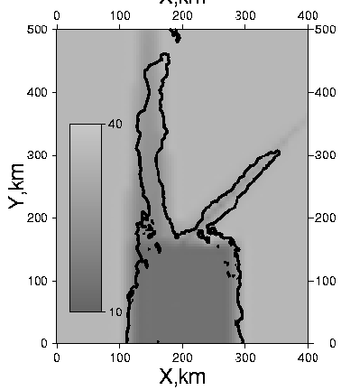
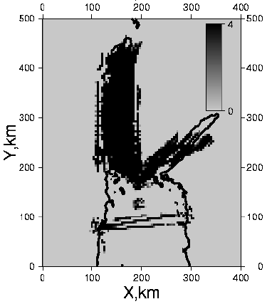
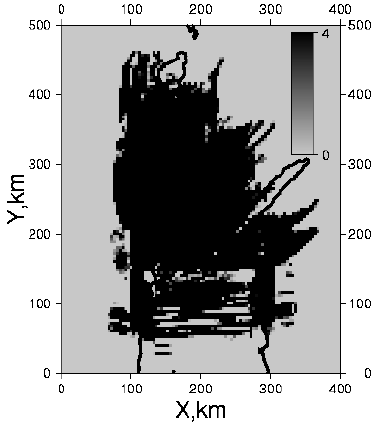
Experiment Design. We have constructed a preliminary three dimensional model of the region. Such a model is necessarily simplistic, given the paucity of data. It is primarily based upon a Moho topograhy map that we constructed using some existing refraction results plus extrapolations based on our understanding of the regional tectonics and our inferences about the degree of crustal thinning. We add a simple three-layer crust above the Moho (with layer boundaries scaling with crustal thickness) and a simple constant-gradient mantle beneath it. We perform three-dimensional point-to-point raytracing through this model using Menke's "raytrace3d" code. This process has enabled us to test the effectiveness of various source and receiver geometries to meet the experimental objectives.
Shot Locations. All sources are airgin shots in water (e.g. produced by the airgin array on R/V Ewing). We have designed set of ship tracks that achieve a fairly uniform shot coverage of the Gulf of Suez (e.g. six 280 km long lines parallel to its axis), the northern part of the Red Sea (eight 160 km lines perpendicular to its axis) and the Gulf of Acuba (two 200 km long lines parallel to its axis). The total length of the airgun lines is 3360 km, which at 9 km/hr takes 373 hours (16 days) to survey. We plan to use the rather slow shot repetition period of 2 minutes in order to reduce water column noise. Approximately 11000 shots will be fired, with an average along-track spacing of 300 m.
Receiver Locations. Receivers include: 1) The long-deployment broadband arrays (i.e. three cross-axis linear arrays plus sparser along-axis arrays along the shores of the Gulfs); 2) A supplementary short-deployment land-based array, mostlly straddling the central part of the Gulf of Suez; and 3) three short-deployment OBS, one in the central Gulf of Suez (29 OBS's), one in the Gulf of Aqaba (5 ONS's) and the other crossing the northern Red Sea (16 OBS's). The total of 205 receivers of all kinds are planned. The supplementary land array and Gulf of Suez OBS arrays are needed to provide good 3D ray coverage in the central Gulf of Suez region. Without them three-dimensional imaging of the crust and Moho would not be possible. The northern Red Sea OBS array is needed to provide north-south oriented rays in the southern end of the study region. Its linear shape allows a complete 2D cross-section of that region to be constructed (including the upper crust).
The supplementary short-deployment land-based array consists of 100 REFTEK 72A-07 recorders with intermediate period CMG40T geophones. We estimate that a crew of three persons, operating from a small truck, can deploy five of these instruments per day. Four such crews (2 in Egypt, 1 in Sinai, one in Saudi Arabia) can deploy all instruments in 5 days and pick them up in 4 days.
The OBS arrays, totaling 50 instruments, will deployed from Ewing. About 1230 km of steaming is required to deploy the instruments (61.5 hours @ 20 km/hr) and an equal amount to recover it. Given the generally shallow water, station times will be small (say 1 hour per OBS). Thus 9 days of ship time will be needed to deploy and recover the arrays.
Maps of imagable regions. We have used the preliminary model to verified that the planned sources and receivers produce coverage of the lower crust, Moho and upper mantle across the study region. The mid-crust is less-well imaged, with coverage limited to the central Gulf of Suez and central Gulf of Acuba regions and to the northern Red Sea cross-section.
Data Processing and Archiving. Raw data from the seismometers will be cleaned and archived in SEG-Y format, with shot times and location, as determined by the airgun firing system, inserted into the headers. Special attention will be given to determining precise OBS clock corrections, using water-wave arrival times from nearby airgun shots.
Semi-automated determination of traveltimes. The process of measuring arrival times of seismic waves on several thousand shot gathers (e.g. 210 stations times 16 lines) is the most labor-intensive part of the seismic data analysis. We have prior experience with a processing code that uses a combination of operator-selected "control points" and cross-correlation analysis to rapidly and precisely measure the arrival times of phases.
Imaging. The crustal imaging will be performed with a standard iterative non-linear least-squares technique. Rays are traced through a reference model, and traveltime residuals with respect to the computed traveltimes are used to infer improvements to the reference model. The reference model is updated and the process is repeated until it converges. There are several publicly-available codes, including our own "raytrace3d", that implement this algorithm.
The PmP data present several new challenges, owing to the expectation of large Moho relief. Several PmP arrivals (or "branches"), from different patches of Moho, may be present on a single gather. Determining which branch is associated with a given patch is expected to be challenging. We expect that comparisons between several neighboring lines, and between observed and forward-modeled test cases, will enable us to sort out such multiple arrivals. The imaging of Moho topography using PmP traveltimes is a somewhat more complicated process than imaging crustal velocity using Pg traveltimes, owing to the trading off of lower crustal velocity and Moho depth. We are currently implementing an enhancement to "raytrace3d" that permits a simultaneous inversion for crustal velocity and Moho depth and which allows the degree of trading off to be quantified. This new algorithm as proven effective in preliminary tests.
After correcting for traveltime through the crust, the Pn traveltime data will be inverted for a two-dimensional map of the variation of an anisotropic velocity, e.g. v(x,y) = v0(x,y) + dv(x,y)*cos(2*(phi-phi0(x,y)). Here v0(x,y) represents the isotropic part of the velocity, dv the degree of anisotropy and phi0 the azimuth of the fast axis. As mentioned above, anisotropy and hetergogeneity strongly trade off, so it will be necessary to enforce smoothness constraints on the spatial variation of dv(x,y) and phi0(x,y).
Documents and Figures