Part 2: Regional Crustal Structure
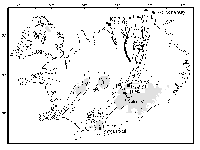
Fig 1: Map of iceland showing tectonic features, stations (triangles) of the B array and earthquake epicenters (squares). Note that the epicenter of the earthquake on the Kolbeinsey Ridge (arrow) is off the top of the map. (PostScript version of map).
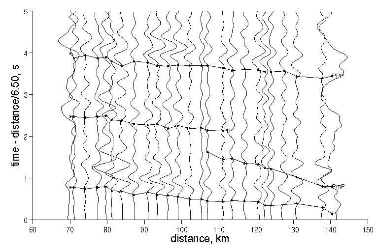
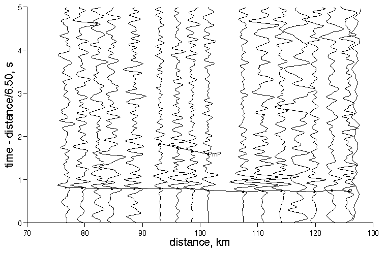
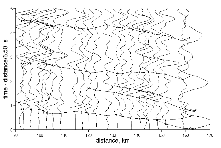
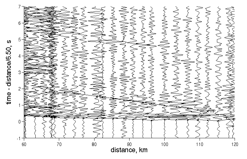
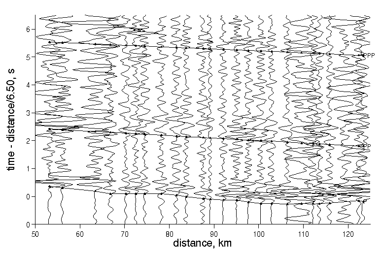
Fig 2: Low-pass filtered, vertical component record section, reduced to 6.5 km/s, of a Vatnajokumm earthquake observed on the B96 array. Note clear P, PmP, PP, and PPP phases. (PostScript version of plot).
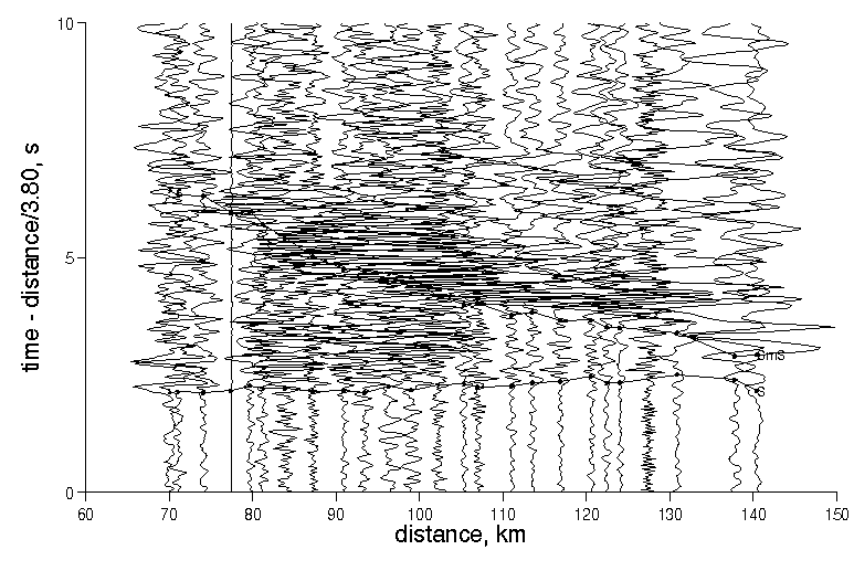
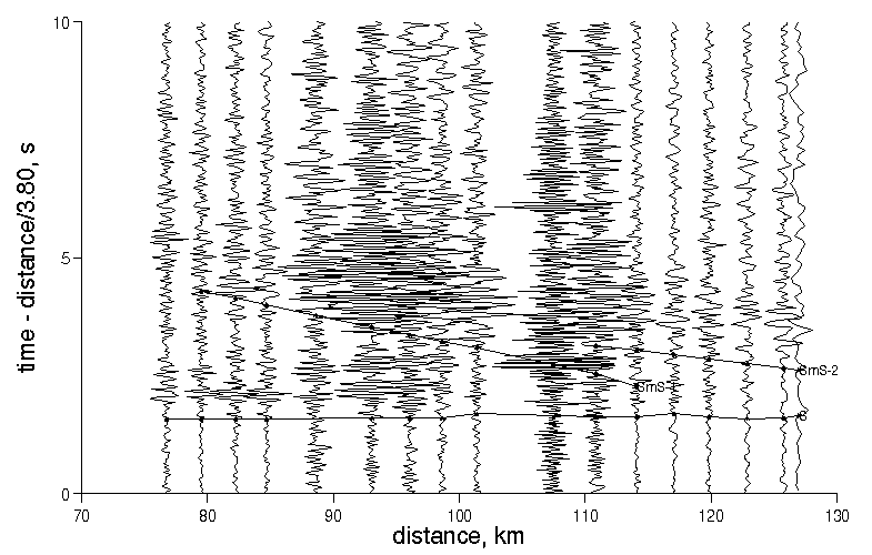
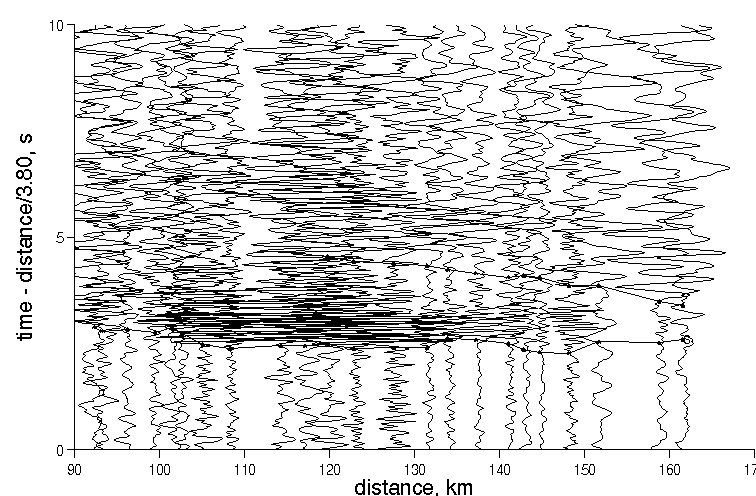
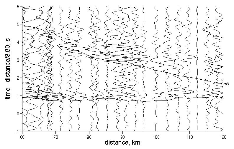
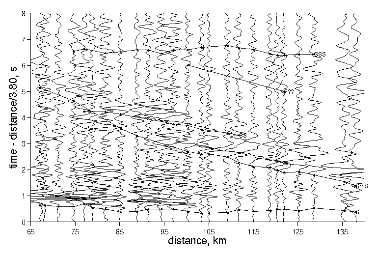
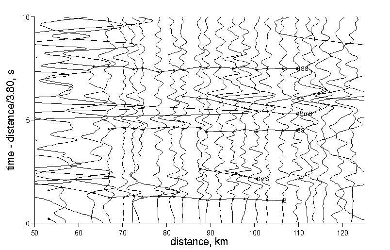
Fig 3: Unfiltered, transverse-horizontal component record section, reduced to 3.8 km/s, of a Vatnajokumm earthquake observed on the B96 array. Note clear S and SmS phases. (PostScript version of plot).
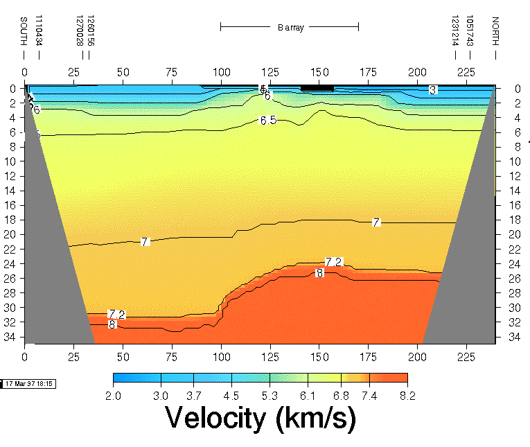
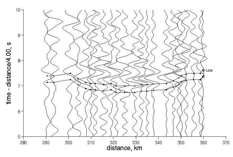
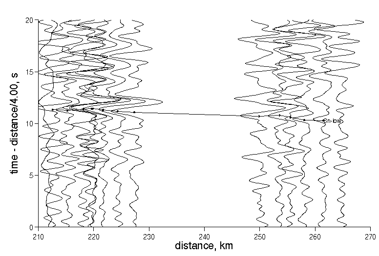
Fig 4: 2-D model of compressional velocity along a NS profile extending from Vatnajokull though Bardardallur to Eyjafjordur, based on traveltimes of P, PmP, PP and PPP phases. The Moho declines from a depth of about 25 km in the north to 31 km in the south. (Color PostScript, B&W PostScript versions of plot, and RTMOD mesh file).
Summary
Design. The B96 array recorded several microearthquakes from source regions north and south of the array (Fig 1). The hypocentral parameters for most of these events have been determined by using arrival times from the SIL and U. Iceland arrays. Record sections for these events often show very clear arrivals of both compressional and shear wave phases. We use these data to determine the regional crustal and upper mantle structure.
The earthquakes fall into four different source regions:
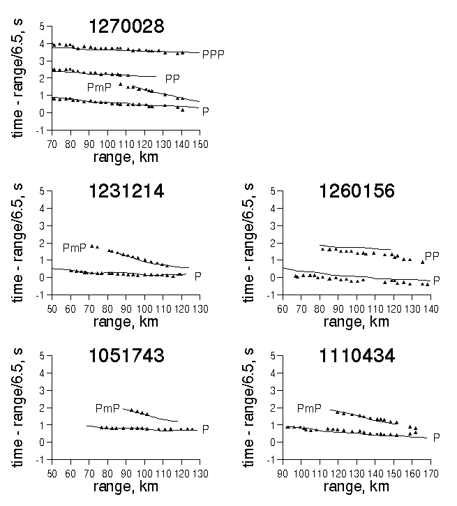
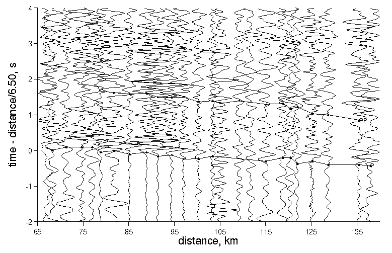
Analysis Arrival times of the major seismic phases were picked "by eye", using a variety of filter settings (Fig 2 and 3). In general, the P and phases are clearly present on the unfiltered seismograms and were usually picked from them directly. The exception is the S phase from Kolbeinsey Ridge and Myrdalsjokull, which were picked from the low-pass filtered seismograms. The PP, PPP, PmP, SS and SmS phases were typically picked from 0.5-2 Hz low-pass filtered seismograms, although traveltimes were compared to the unfiltered records and adjusted for time-shifts introduced by the filtering.
A 2D compressional velocity model extending from Vatnajokull, north along the B96 array to Eyjafjordur was created using traveltime data from the Vatnajokull and Eyjafjordur earthquakes (Fig 4). The model of shallow structure from the previous section was used to constrain the structure beneath the array, The P traveltime constrain the mid crustal velocities, PmP-P traveltime differences constrain crustal thickness, and PP-P and PPP-P traveltime differences constrain the velocities in the slow, near-surface material. The resulting model fits the data well, except that the P traveltimes from two two neighboring Vatnajokull earthquakes cannot be exactly reconciled (possibly due to errors in hypocentral location). This discrepancy results in a small (0.2s) static anomaly for event (1260156).
Apparent velocities were computed by the least-quares fitting of straignt lines to the linear portions of the traveltime curves (i.e. the short range part of PmP and SmS was omitted). For events in the 70-130 km range, the Pg and Sg rays (with apparent velocities of 6.58-6.86 km/s and 3.78-3.89 km/s, respectively) trurn in the mid-crust. A lower-crustal Pg (with an apparent velocity of 7.34 km/s) is observed from a more distant source (Myrdalsjokull). Clear Pn and Sn waves are also observed from the Myrdalsjokull and Kolbeinsey Ridge regions, with apparent velocities in the 7.66-8.00 km/s and 3.96-4.37 km/s, respectively.
Velocity ratios were then computed by simple division. This technique for determining the compressional to shear velocity ratio is insensitive to uncertainties in source depth and origin time. Ratios were in the range:
| region sampled | P/S velocity ratio | phases |
| upper crust | 1.74-1.83 | Pg and Sg |
| lower crust | 1.68-1.79 | PmP and SmS |
| uppermost mantle | 1.85-1.93 | Pn and Sn |
The velocity ratio for the mantle is generally higher than the crust.
Results
Supporting data
| name | region | P-wave | P-wave | S-wave | S-wave | AH-data | AH-data | AH-data |
| 1051743 | eyja | gif | ps | gif | ps | Z | N | E |
| 1080943 | kolb | gif | ps | gif | ps | Z | N | E |
| 1110434 | vatn | gif | ps | gif | ps | Z | N | E |
| 1171351 | myrd | gif | ps | gif | ps | Z | N | E |
| 1231214 | eyja | gif | ps | gif | ps | Z | N | E |
| 1260156 | vatn | gif | ps | gif | ps | Z | N | E |
| 1270028 | vatn | gif | ps | gif | ps | Z | N | E |
| 1290146 | skja | gif | ps | gif | ps | Z | N | E |
| name | region | observed (rsx) | observed (RTMOD) | predicted (RTMOD) |
| 1051743 | eyja | rsx | rtmod | rtmod |
| 1080943 | kolb | rsx | -- | -- |
| 1110434 | vatn | rsx | rtmod | rtmod |
| 1171351 | myrd | rsx | -- | -- |
| 1231214 | eyja | rsx | rtmod | rtmod |
| 1260156 | vatn | rsx | rtmod | rtmod |
| 1270028 | vatn | rsx | rtmod | rtmod |
| 1290146 | skja | rsx | rtmod | -- |
| region | event | Pn | ePn | Sn | eSn | Rn | eRn | Pg | ePg | Sg | eSg | Rg | eRg | PmP | ePmP | SmS | eSmS | Rm | eRm |
| kolb | 1080943 | 7.66 | 0.04 | 3.96 | 0.03 | 1.93 | 0.01 | -- | -- | -- | -- | -- | -- | -- | -- | -- | -- | -- | -- |
| eyja | 1051743 | -- | -- | -- | -- | -- | -- | 6.58 | 0.01 | 3.79 | 0.01 | 1.74 | 0.01 | 8.07 | 0.01 | 4.81 | 0.02 | 1.68 | 0.01 |
| eyja | 1231214 | -- | -- | -- | -- | -- | -- | 6.67 | 0.01 | 3.78 | 0.01 | 1.77 | 0.01 | 7.98 | 0.01 | 4.53 | 0.04 | 1.76 | 0.02 |
| skja | 1290146 | -- | -- | -- | -- | -- | -- | 6.73 | 0.06 | 3.89 | 0.02 | 1.73 | 0.03 | -- | -- | 4.42 | 0.03 | -- | -- |
| myrd | 1171351 | 8.00 | 0.1 | 4.31 | 0.04 | 1.85 | 0.02 | 7.34 | 0.10 | -- | -- | -- | -- | -- | -- | -- | -- | -- | -- |
| vatn | 1110434 | 7.70 | 0.1 | -- | -- | -- | -- | 6.78 | 0.03 | 3.87 | 0.02 | 1.75 | 0.02 | 7.55 | 0.06 | 4.21 | 0.03 | 1.79 | 0.03 |
| vatn | 1270028 | -- | -- | -- | -- | -- | -- | 6.86 | 0.02 | 3.75 | 0.01 | 1.83 | 0.01 | 7.75 | 0.07 | 4.33 | 0.05 | 1.79 | 0.04 |
| vatn | 1260156 | -- | -- | -- | -- | -- | -- | 6.81 | 0.02 | 3.84 | 0.01 | 1.77 | 0.01 | -- | -- | 4.35 | 0.04 | -- | -- |
Explanation: