Applications of the POCS Inversion Method
Abstract. We apply the method of Projection Onto Convex Sets (POCS) to the problem of solving geophysical inverse problems. The advantage of this iterative method is its flexibility in handling non-linear equality and inequality contraints, including constraints on the spectrum of unknown functions. We give examples of using POCS to interpolate topographic profiles, topographic maps, and the physical properties of the earth between well logs.

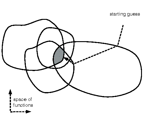
Fig 1.(A) Every point in function space corresponds to a different function. These functions are grouped into sets sharing a common property, as indicated by the closed curves. A point of intersection of the sets (in the shaded region) is found by starting with an initial guess of the function, and then sequentially projecting it onto the surfaces of the sets. (PostScript Version).

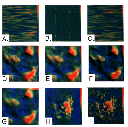
Fig 2.(A) Synthetic field with anisotropic spectrum. (B) Well logs through A. (C) POCS interpolation based on well logs in B. (D) Synthetic topography with a fractal character. (E) Smooth spline interpolation of 32x32 point, subsampled version of D. (F) Rough POCS inversion acheived with constraint of fractal spectrum, where the fractal dimension is estimated from the subsampled data. (G) Smooth POCS interpolation acheived with constraint of exponentially decaying spectrum, is similar to E. (H) Smooth spline interpolation of ETOPO5 Rocky Mountain data acheived; (I) Rough POCS interpolation of ETOPO5 Rocky Mountain data acheived with constraint of fractal spectrum, where the fractal dimension is estimated from the data. Images H and I are 1200 km across. (Enlargements A, B, C, D, E, F, G, H, I).
Menke, W., Applications of the POCS inversion method to interpolating topography and other geophysical fields, Geophys. Res. Lett. 18, 435-438, 1991.
POCS fractal interpolation program pocs_surface.tar.Z (WARNING. NO WARRANTY IS PROVIDED WITH THIS SOFTWARE. USE AT YOUR OWN RISK!)