Welcome to
the TUCAN Web Page
UNDER CONSTRUCTION!
TUCAN is Tomography (and other things) Under Costa rica And
Nicaragua
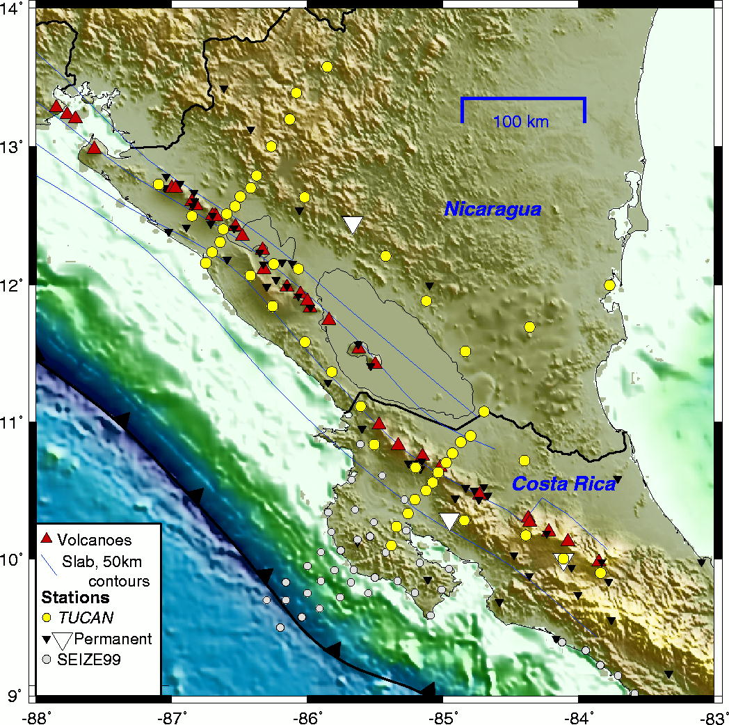
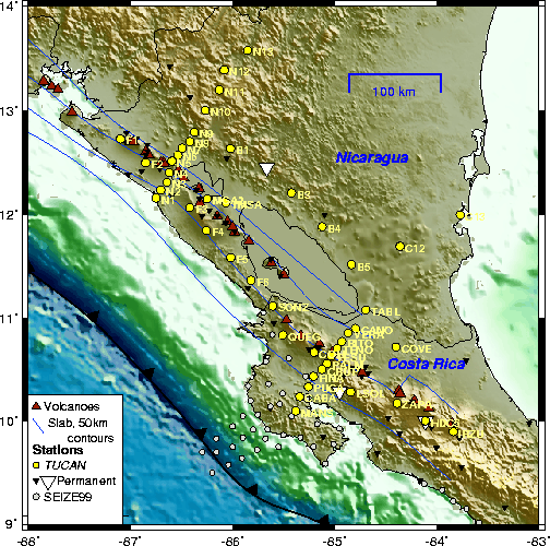
The TUCAN Array, July 2004 - March 2006
TUCAN is a major deployment of 48
broadband seismographs,
2003-2006, to image the mantle wedge and subducting plate in Central
America. The aim is to better understand the processes that
control
melting beneath arc volcanoes, the flow field and water cycle in
subduction
zones, and ultimately better understand why arc volcanism occurs.
The
Central
American convergent margin is an excellent target for seismic imaging
because the arc exhibits nearly the complete global range in
geochemical
indicators of the subducting plate (e.g., 10Be, Ba/La) as
well as
some of the largest variations in indicators for degree of mantle
melting. Nearly all of these changes occur between western
Nicaragua and
central Costa Rica. For these reasons, the Central America arc
has been
chosen as one of two Focus Areas for the US-MARGINS
Subduction Factory Initiative.
The
Proposal
(ftp
proposal
here in 6Mb PDF) or just the (Project
Summary PDF)
Major
Collaborators
Boston University
Brown University
OVSICORI - Universidad National
Autonoma
Costa Rica
INETER
- Nicaragua
Funding provided by the U.S. National Science
Foundation,
MARGINS program
Instruments made available by the IRIS-PASSCAL
Instrument Center
Publications
(student authors underlined)
MacKenzie,
L.M., G.A. Abers, S. Rondenay
and K.M. Fischer, Imaging a steeply dipping subducting
slab in southern Central America, Earth Planet. Sci. Lett.,
submitted.,
2010.
Abt, D.L., K.M. Fischer,
G.A.
Abers, J.M.
Protti, V. González
and W. Strauch, Constraints on upper mantle anisotropy surrounding the
Cocos
slab from SK(K)S splitting, J. Geophys. Res., in press, 2010.
French,
S.W., L.M. Warren, K.M. Fischer, G.A. Abers, W. Strauch, J. M. Protti, and
V.Gonzalez.
Constraints on upper-plate deformation in the Nicaragua subduction zone
from
earthquake relocation and directivity analysis, Geochem. Geophys.
Geosyst., 11,
art. no. 3, doi:10.1029/2009GC002841, 2010.
Abt, D.L., K.M. Fischer, G.A. Abers, W. Strauch, J.M. Protti and V. Gonzalez, Shear-wave anisotropy beneath Nicaragua and Costa Rica: Implications for flow in the mantle wedge, Geochem. Geophys. Geosyst., 10, Q05S15, doi:10.1029/2009GC002375, 2009.
Rychert,
C.A., K.M. Fischer, G.A. Abers,
T. Plank, E.M. Syracuse, J.M. Protti, V.
Gonzalez, and W. Strauch, Strong along-arc variations in attenuation in
the
mantle wedge beneath Costa Rica and Nicaragua, Geochem. Geophys.
Geosyst.,
9, Q10S10, http://dx.doi.org/10.1029/2008GC002040, 2008.
Harmon, N., P. Gertsoft, C.A. Rychert, G.A. Abers, M. Salas de la Cruz,
and K.M. Fischer, Phase
velocities from seismic
noise using beamforming and cross correlation in Costa Rica and
Nicaragua, Geophys.
Res. Lett., 35,
L19303,
doi:10.1029/2008GL035387, 2008.
MacKenzie, L.S., G.A. Abers, K.M. Fischer, E.M. Syracuse, J.M.
Protti, V.
Gonzalez, and W. Strauch, Crustal structure along the southern Central
American
volcanic front, Geochem. Geophys. Geosyst., 9, Q08S09,
doi:10.1029/2008GC001991, 2008.
Syracuse, E.M., G.A. Abers, K.M. Fischer, McKenzie, L., C. Rychert, J. M. Protti,
V.
Gonzalez, and W. Strauch, Seismic tomography and earthquake locations
in the
Nicaraguan and Costa Rican upper mantle, Geochem. Geophys.
Geosyst., 9,
Q07S08, doi:10.1029/2008GC001963, 2008.
Hoernle, K., D. Abt, K. Fischer, H. Nichols, F. Hauff, G. Abers, P. van den Bogaard, G. Alvarado, M. Protti and W. Strauch, Geochemical and geophysical evidence for arc-parallel flow in the mantle wedge beneath Costa Rica and Nicaragua, Nature, 451, 1094-1097, 2008.
Deployment
Information
The
initial
deployment was completed July-August 2004, and after several
service runs, most instruments were removed
March 2006, with some remaining another 8 months. This section
was put together during the deployment to help operator teams.
All data are now available at the IRIS Data Management Center.
Station map -- Updated
following the
initial deployment, November 2004.
Station list (text file)
Summary of station SYSTEM
POWERUP messages
Current up-time plot
(PDF) showing 96% aggregate up time for data through
March 2005 submitted to IRIS