

The 4D Inversion Product connects our 4D Rapid Analysis Product to a unique 4D seismic inversion and modeling package that is custom-designed to compensate for processing and acquisition differences between 3D seismic surveys. Impedance changes over time are determined and oil/gas/water volumes at each voxel are monitored. Expected oil and gas flow rates and volumes can be calculated for new well placements to capture bypassed pay and increase recovery efficiency.
As 4D seismic technologies are merging with reservoir characterization, acoustic impedances become the critical link between seismic and petrophysical property distributions in hydrocarbon reservoirs. Unlike seismic amplitudes, which measure relative acoustic impedance changes across interfaces, acoustic impedance is directly associated with velocity and density properties of rock and the fluids that fill pore spaces. Our 4D Inversion Product uses the existing acoustic logs in wells and a stochastic simulation technique to derive realistic acoustic impedance changes over time. The inverted acoustic impedance volumes are then used to derive reservoir characteristics and further quantify the drainage results obtained from our 4D Rapid Analysis Product's amplitude attribute extraction.
Most seismic inversion methods do not account for all aspects of seismic wave propagation, and are rather simple though cost-effective (e.g., the "run-sum" technique). Our nonlinear, 4D seismic inversion is a robust, least-squares minimization technique. It uses convolution as the seismic forward model to compute the seismic response of acoustic impedance at each iteration. The gradients of the model response versus acoustic impedance are used to update the acoustic impedance model continuously.
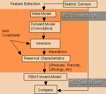
In the 4D Inversion Product, seismic wavelets are dynamically extracted from every seismic trace. We extract a wavelet "source and processing cube" unique to each 3D survey. We then extract the differences in acquisition and processing between surveys to produce normalized datasets ready for 4D differencing. As a result, we are able to image dynamic changes in reservoir fluids that have occurred between the acquisition times of the various 3D surveys.
The combination of the 4D Rapid Analysis Product,which gives better prediction of reservoir drainage patterns, and the 4D Inversion Product, with its better prediction of reservoir petrophysical property changes, significantly increases the accuracy of oil and gas identification during the reservoir monitoring process.

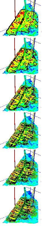
Here, for example, green (oil) and red (gas) indicate bypassed hydrocarbon
locations within the LF reservoir in the Eugene Island 330 Field of offshore
Louisiana. Blue identifies water encroachment that
has been more complex than simple gravitational drainage


For more information, contact:
4D Technology, Inc.
9550 Forest Lane Suite 530
Dallas Tx 75243
(214) 342-5335
(214) 342-5337 (fax)
![]()
About 4D Technology Inc.