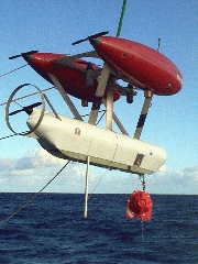
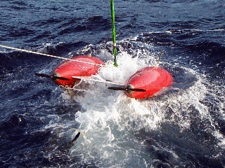
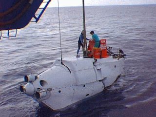
ABE SEPR-99 Engineering Results
RV Atlantis Voyage 3 Leg 31
M.H. Cormier*, W. Ryan*, D. Yoerger**, A. Bradley**, R. Catanach**, A. Duester**
* Lamont-Doherty Earth Observatory
** Woods Hole Oceanographic Institution
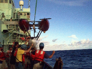
Photos by Cindy van Dover
More photos
Area plots
Description of data structures
Some matlab utilities
Dive Summaries, Plots, and Data Files
ABE23
| date: | 99/02/05 |
|---|
| start: | 19:34:17 |
|---|
| bottom: | 22:01:15 |
|---|
| end: | 24:40:05 |
|---|
| survey time: | 02:38:50 |
|---|
| distance on bottom: | 5300 |
|---|
| number of pictures: | 0 |
|---|
Summary
A zig-zag across the ridge. Ran for 2.6 hours on bottom.
Had 2 good ranges most of the time, 9.5 and 11.0 were intermittant. Crossed
the ridge 3 times. Imagenix worked OK. Took pictures on the mooring. Dive
ended on a battery trip (46 volts). Got good maggy. We used the bottom
ducer after getting to the bottom. Nav got better with post processing.
The net survey could be improved.
Plots for ABE 23
Data for ABE 23ABE24
| date: | 99/02/06 |
|---|
| start: | 21:40:12 |
|---|
| bottom: | 24:04:19 |
|---|
| end: | 27:00:09 |
|---|
| survey time: | 02:55:50 |
|---|
| distance on bottom: | 5800 |
|---|
| number of pictures: | 0 |
|---|
Summary
Another zig-zag, no imagenix. nearly constant depth except
over ridge top. Nav pretty ratty, lots of missing ranges. Crossed the ridge
3 times. Still using top ducer when on bottom.
Plots for ABE 24
Data for ABE 24ABE25
| date: | 99/02/07 |
|---|
| start: | 21:07:21 |
|---|
| bottom: | 23:29:09 |
|---|
| end: | 25:24:09 |
|---|
| survey time: | 01:55:00 |
|---|
| distance on bottom: | 3600 |
|---|
| number of pictures: | 708 |
|---|
Summary
No imagenix, flying 5-7 meters for camera. Made two lines
1400 meters long running approx along-contour (S-N). Lines were 200 meters
apart. 400 meters into line 3 when batteries died at 46 volts, 2 hours
on bottom. Nav very solid, used bottom ducer the entire run. Transponder
survey would benefit from adjustment.
Plots for ABE 25
Data for ABE 25ABE27
| date: | 99/02/10 |
|---|
| start: | 21:14:46 |
|---|
| bottom: | 23:32:53 |
|---|
| end: | 24:12:33 |
|---|
| survey time: | 00:39:40 |
|---|
| distance on bottom: | 1200 |
|---|
| number of pictures: | 31 |
|---|
Summary
Running cross lines in the rift valley at the middle site.
Nav poor,batteries quit after 45 minutes at 46 volts. Battery pack is not
working correctly. Nav poor because a bounce was getting in on 11.0. Had
imagenix running, but no 1 second attitude sampling (software problem). The
maggy failed on the way down, and was not working during the calibration spin,
but it appears to be ok after ABE reached 1000 meters.
Plots for ABE 27
Data for ABE 27ABE28
| date: | 99/02/11 |
|---|
| start: | 21:06:18 |
|---|
| bottom: | 23:27:05 |
|---|
| end: | 24:16:48 |
|---|
| survey time: | 00:49:43 |
|---|
| distance on bottom: | 400 |
|---|
| number of pictures: | 75 |
|---|
Summary
ABE went walkabout due to a navigation problem. While
we had tightened up the range gates to prevent bounce returns from getting
in after the vehicle reached, the bottom, a bad fix received just before
touchdown made ABE think it was far to the south. This made the trackline
controller fall through all the tracks until the last. ABE tried to get
to that trackline (using the bad fix), then the nav recovered and it tried
the correct direction. BE quit when it had crossed the end line for the
last trackline., 45 minutes of survey. ABE climbed up the wall of the valley
on the east side, climbing about 70 meters. We had imagenix and 1-sec attitude
recording on this run.
Plots for ABE 28
Data for ABE 28ABE29
| date: | 99/02/12 |
|---|
| start: | 18:58:53 |
|---|
| bottom: | 21:17:00 |
|---|
| end: | 23:09:00 |
|---|
| survey time: | 01:52:00 |
|---|
| distance on bottom: | 3200 |
|---|
| number of pictures: | 53 |
|---|
Summary
ABE had a nav problem at the beginning (again). This time
if fell through the first two lines, but did all the rest. So it "cut the
switchbacks" on the first two lines. ABE quit when it ran out of battery
power after 2 hours. The voltage limit was set to 45.5 volts. Reprocessed
nav very good.
Plots for ABE 29
Data for ABE 29ABE30
| date: | 99/02/13 |
|---|
| start: | 22:44:04 |
|---|
| bottom: | 25:02:11 |
|---|
| end: | 28:00:01 |
|---|
| survey time: | 02:57:50 |
|---|
| distance on bottom: | 5900 |
|---|
| number of pictures: | 37 |
|---|
Summary
We reconfigured ABE's lbl rcvr, as we were working at a more southern site,
where we stayed for the rest of the runs at the middle site.
This run started up on the top of the valley wall, getting
around the bad acoustic conditions that effected the previous two runs.
We also made some software fixes that would make it less likely we'd act
on a bad fix. We crossed the valley 3 times, and started on the 4th when
we timed out at 0400. Imagenix coverage was a bit spotty, we lost ranges
a lot especially while descending. The reprocessed nav is good, but could
be improved by some transponder adjustments. We nicknamed this area "The
Half Pipe".
The transponder positions were resurveyed using in-hull nav data, and the
nav tracks and dotcloud were rerun.
Plots for ABE 30
Data for ABE 30ABE31
| date: | 99/02/14 |
|---|
| start: | 20:18:13 |
|---|
| bottom: | 22:35:50 |
|---|
| end: | 25:34:48 |
|---|
| survey time: | 02:58:58 |
|---|
| distance on bottom: | 5500 |
|---|
| number of pictures: | 42 |
|---|
Summary
We continued the survey in the Half Pipe, adding four
more lines to the south and ending with a long line down the flank to the
west. The run ended when ABE reached the last waypoint after 3 hours. We
had raised the imagenix gains as an experiment to 6 on the first leg, with
no ill effects. We also slowed the vehicle on the downward sections,
which helped it keep contact. The reprocessed nav looks good, but would
benefit from a transponder adjustment.
The transponder positions were resurveyed using in-hull nav data, and the
nav tracks and dotcloud were rerun.
Plots for ABE 31
Data for ABE 31ABE32
| date: | 99/02/15 |
|---|
| start: | 20:42:56 |
|---|
| bottom: | 23:04:53 |
|---|
| end: | 27:00:04 |
|---|
| survey time: | 03:55:11 |
|---|
| distance on bottom: | 6100 |
|---|
| number of pictures: | 53 |
|---|
Summary
More in the Half Pipe, with four more lines to the north
of ABE30 lines, with a run down the eastern flank. We ran with an Imagenix
gain of 6, and tried 12 on the first leg, which looked fine. We slowed
on the downhill sections, as in ABE31. Total time on bottom 3hrs 46 minutes.
The assembled imagenix map from ABE30-32 looks good.
The transponder positions were resurveyed using in-hull nav data and the tracklines
and dot cloud were rerun
Plots for ABE 32
Data for ABE 32ABE34
| date: | 99/02/18 |
|---|
| start: | 22:50:48 |
|---|
| bottom: | 25:52:55 |
|---|
| end: | 28:00:05 |
|---|
| survey time: | 02:07:10 |
|---|
| distance on bottom: | 4500 |
|---|
| number of pictures: | 0 |
|---|
Summary
We got in late following the thruster repairs (given the
task, we felt lucky to get in at all, great job Rod and Matt!). We ran
for 2 hours, 4 minutes, and quit when our time expired at 0400. We ran
5 1/2 lines of 600 meters each, and one of 1200 meters next to the Crack
of Doom. Nav and control were both excellent for the entire run. We later
adjusted the xpndr positions a bit, and the nav got even better (little
to no jump as the xpndr combinations changed). The processed imagenix map
looked good, we could clearly see one end of the crack, which aided in
planning the next night's legs.
The transponder positions were resurveyed using in-hull nav data and the tracklines
and dot cloud were rerun
Plots for ABE 34
Data for ABE 34ABE35
| date: | 99/02/19 |
|---|
| start: | 18:35:26 |
|---|
| bottom: | 21:29:03 |
|---|
| end: | 26:10:12 |
|---|
| survey time: | 04:41:09 |
|---|
| distance on bottom: | 10200 |
|---|
| number of pictures: | 38 |
|---|
Summary
We ran for 4 hours and 45 minutes. The run ended when
we reached the end of the last trackline. we did 7 1/2 600 meter tracklines
to the west of the 600 meter segments from the previous dive, then did
5 one kilometer tracks on both sides of the crack. Reprocessing improved
the nav considerably, filling some gaps and decreasing jumps during baseline
switches. The imagenix map looked very good, one km. of the Crack was shown
clearly, including channels to the west. Imagenix map clearly improved
by the nav recrunch.
The transponder positions were resurveyed using in-hull nav data and the tracklines
and dot cloud were rerun
Plots for ABE 35
Data for ABE 35ABE36
| date: | 99/02/20 |
|---|
| start: | 18:32:42 |
|---|
| bottom: | 21:25:59 |
|---|
| end: | 26:25:12 |
|---|
| survey time: | 04:59:13 |
|---|
| distance on bottom: | 10800 |
|---|
| number of pictures: | 0 |
|---|
Summary
Three more long lines of the Crack area on the east side,
four more to the west. Also made a tie line across the channel at the south
end of the crack. Imagenix map getting better. Wen processed it for
slope: excellent. We ran for four hours, 56 minutes, and ended when we
reached the last waypoint. Total trackline length was 10.56 km. Sinton
dove with the map in Alvin.
The transponder positions were resurveyed using in-hull nav data and the tracklines
and dot cloud were rerun
Plots for ABE 36
Data for ABE 36ABE37
| date: | 99/02/21 |
|---|
| start: | 18:28:15 |
|---|
| bottom: | 21:19:02 |
|---|
| end: | 26:31:12 |
|---|
| survey time: | 05:12:10 |
|---|
| distance on bottom: | 11300 |
|---|
| number of pictures: | 915 |
|---|
Summary
Filled in the missing section of the box to the
west and extended total coverage to the west by 2 lines also made a long
2-way video transect to the north of the area (5-7m bottom following).
Camera got only ~50 percent of the shots, might by fixable by changing software
settings. Total time on bottom, 5 hrs 18 minutes, total track distance
11.0 km.
The transponder positions were resurveyed using in-hull nav data and the tracklines
and dot cloud were rerun
Plots for ABE 37
Data for ABE 37ABE38
| date: | 99/02/22 |
|---|
| start: | 18:27:60 |
|---|
| bottom: | 21:28:17 |
|---|
| end: | 27:12:00 |
|---|
| survey time: | 05:43:43 |
|---|
| distance on bottom: | 12100 |
|---|
| number of pictures: | 338 |
|---|
Summary
Drove a 300 meter, 2-way video leg to the west, then extended
the area 6 lines to the west. Drove a tie line west-to-east along
the north edge, then drove a 1500 meter line to the north, out of the box,
along the Crack. Camera hit rate up to about 90 percent after change in the settings.
The transponder positions were resurveyed based on the in-hull navigation, and the
tracklines and dot cloud recrunched.
Plots for ABE 38
Data for ABE 38ABE39
| date: | 99/02/23 |
|---|
| start: | 18:38:58 |
|---|
| bottom: | 21:38:25 |
|---|
| end: | 26:35:24 |
|---|
| survey time: | 04:56:59 |
|---|
| distance on bottom: | 10300 |
|---|
| number of pictures: | 2568 |
|---|
Summary
Primarily a video snapshot run. We drove up several features on the SW portion of
the main area, crossed over the Crack of Doom at video height, then headed north. We laid
in some Imagenix lines on the north east side, then completed 7 video lines spaced
15 meters apart
The transponder positions were resurveyed using in-hull nav data, and the
nav tracks and dotcloud were rerun.
Plots for ABE 39
Data for ABE 39ABE40
| date: | 99/02/24 |
|---|
| start: | 19:35:49 |
|---|
| bottom: | 22:27:26 |
|---|
| end: | 27:30:07 |
|---|
| survey time: | 05:02:41 |
|---|
| distance on bottom: | 10400 |
|---|
| number of pictures: | 1747 |
|---|
Summary
We made 8 40 meter spaced tracklines at imagenix height, then made almost 9
15 meter spaced tracklines at video height. We took our first wax core midway
through the first video leg.
The transponder positions were resurveyed using in-hull nav data, and the
nav tracks and dotcloud were rerun.
Plots for ABE 40
Data for ABE 40ABE41
| date: | 99/02/25 |
|---|
| start: | 18:59:11 |
|---|
| bottom: | 21:48:19 |
|---|
| end: | 23:43:50 |
|---|
| survey time: | 01:55:31 |
|---|
| distance on bottom: | 4000 |
|---|
| number of pictures: | 324 |
|---|
Summary
Data logger failed (disk full) after 2 hours on bottom. Took one core shortly
after, and took another core later. Vehicle appeared to follow the program
exactly, desired positions of cores should be correct. Made 5 imagenix lines,
filling some key gaps before logger quit. Total run time was 6 hours, not that
it counts.
The transponder positions were resurveyed using in-hull nav data, and the
nav tracks and dotcloud were rerun.
Plots for ABE 41
Data for ABE 41
Post-processed Nav plots
ABE 23 Nav
ABE 24 Nav
ABE 25 Nav
ABE 27 Nav
ABE 28 Nav
ABE 29 Nav
ABE 30 Nav
ABE 31 Nav
ABE 32 Nav
ABE 34 Nav
ABE 35 Nav
ABE 36 Nav
ABE 37 Nav
ABE 38 Nav
ABE 39 Nav
ABE 40 Nav
ABE 41 Nav
Scanning sonar plots
ABE 23 Bathy
ABE 24 Bathy
ABE 25 Bathy
ABE 27 Bathy
ABE 28 Bathy
ABE 29 Bathy
ABE 30 Bathy
ABE 31 Bathy
ABE 32 Bathy
ABE 34 Bathy
ABE 35 Bathy
ABE 36 Bathy
ABE 37 Bathy
ABE 38 Bathy
ABE 39 Bathy
ABE 40 Bathy
ABE 41 Bathy
ABE SEPR-99 Engineering Results
RV Atlantis Voyage 3 Leg 31
M. Cormier*
W. Ryan*
D. Yoerger**
A. Bradley**
R. Catanach**
A. Duester**
* Lamont-Doherty Earth Observatory
** Woods Hole Oceanographic Institution
Webmaster: D. Yoerger