John Sinton (transcript)
Scott White(transcript)
Steve Faluotico pilot
launch = 18° 16.92'S 113° 21.68'W
Objectives:
1. Constrain the limits of the "lava lake" near 18°
17-18'S
sample walls on both sides (especially east)
appreciate and sample "bench" on E side of graben
enjoy and sample narrow inner ditch
2. Visit, sample, and ponder the origin of the oblique structure
stiking 010.
Dive Plan
1. Enter graben from the east side over relatively gentle slopes
2. Cross the oblique structure on the way to the inner ditch
3. Zig, zag, and follow every interesting feature encountered
4. Sample east wall and summit of east flank on the way home.
Way Points [net origin = 18° 20'S 113° 24'W
X Y
1 4080 5680
2 2590 4800
3 3210 4040
4 2460 4040
5 2670 3740
6 2600 3590
7 3230 3000
8 3250 3510
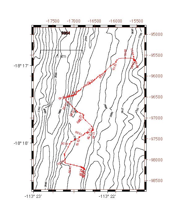
Summary: This dive explored the flanks and axis of the
EPR near 18° 18'S. The axis in this region is characterized
by an asymmetric graben that is about 700 m wide. The dive began
on the eastern flank where a folded sheet flow is present. This
flow and nearby lobate lavas clearly flowed from west to east,
suggesting that they were either erupted from an axial high that
is no longer present or off-axis close to the present wall of
the graben. The presence of significant sediment on this flow
does not support the latter interpretation. Two major fault scarps,
each about 10-12 m high mark the eastern boundary of the axial
graben. The central graben actually consists of nested graben,
with the deepest part (> 2700 m) close to the western wall
which, in contrast to the eastern boundary, consists of a single
scarp interrupted only by small ledges. Most of the graben floor
in this region is strongly faulted into horst and graben structure,
with vertical walls of 10 m being commonly observed. A variety
of sheet, lobate and pillow lavas make up the floor of the graben.
At least one pillow flow appears to drape pre-existing topography
with moderately steep slopes, suggesting that it apparently was
erupted after the graben had developed topography not greatly
different from what it is now. This flow, and most others where
flow directions could be discerned, appears to have flowed across
the graben floor from west to east, suggesting that many eruptive
fissures were present on the western side where the deepest, inner
graben structure is now.
Evidence for previous hydrothermal activity is widespread in the axial graben, particularly along and just to the east of the western, inner graben. Near 18° 18'W the entire inner graben floor is covered with several tens to hundreds of extinct chimneys up to about 12 m high and extensive deposits of hydrothermal sediments.
Sample Locations:
Sample # Latitude (° S) Longitude (° W)
1       18° 16.93' 113° 21.64'
2       18° 16.95' 113° 21.89'
3       18° 17.09' 113° 22.05'
4       18° 17.18' 113° 22.15'
5       18° 17.38' 113° 22.43'
6       18° 17.42' 113° 22.59'
7       18° 17.64' 113° 22.34'
8       18° 17.83' 113° 22.21'
9       18° 17.93' 113° 22.38'
10      18° 17.95' 113° 22.42'
11      18° 18.24' 113° 22.29'
12      18° 18.26' 113° 22.25'
Plots: