|
 |
|
|---|
Leveraging Local Knowledge to Measure Greenland Fjords
Field Locations
Lamont-Doherty Earth Observatory
Field Locations
 |
|---|
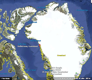
| Map of Northwest Greenland with red dot at Kullorsuaq |
Kullorsuaq
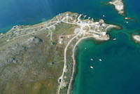
Our primary destination is Kullorsuaq an island settlement in northwest Greenland, the northernmost settlement of the Upernavik Archipelago. Located in the southern end of Melville Bay, part of the larger Baffin Bay, this island community is named for the prominent upright mountain in the center of the island, translated as 'Big Thumb'. The broader area has a lengthy history of use by local hunters but formed into the Kullorsuaq island community in 1928. Today it remains one of the most traditional hunting and fishing villages in Greenland. The population is ~450 permanent inhabitants.
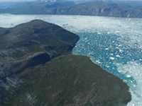
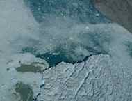
Kullorsuaq lies in the fjord of the Alison Glacier in an area of northwestern Greenland that has in the last decade been experiencing measurable change. Modeled ocean temperature measurements suggest this region has been receiving warming ocean water which is destablizing the series of tidewater glaciers that rims the coastline. Our field data will contribute important information and establish a model for working with local communities to collect additional measurements.
![]()
This project is funded through LDEO Climate Center with additional funding from NASA Interdisciplinary Program & logistical support from NSF. | contact us | web master