 Return
to the Black Rock Forest Student Investigations Home Page
Return
to the Black Rock Forest Student Investigations Home Page Return
to the Black Rock Forest Student Investigations Home Page
About the Harvester Puzzles:
Harvester Puzzles are designed to help students learn:
(a) to use the Earth Curriculum Data Harvester , and
(b) to use Earth data to answer questions.
The questions posed in the Harvester Puzzles are questions from everyday life: what clothing should we bring on our camping trip? do we need a tent for our wedding? and so forth. The pedagogical idea behind the Harvester Puzzles is to give students a chance to learn to manipulate and think about data, without asking them to struggle with new concepts in Earth Science at the same time.
Note that there is more than one way to solve many of the Harvester Puzzles. For example, the first puzzle could be solved by making a time series graph of 10cm and 100cm soil temperature over the course of a year. That's how we've done it in the worked-out answer. But the same puzzle could also be solved by making a scatter plot of 10cm soil temp versus100cm soil temp for the entire data set, and checking to see whether the "cloud" of data points extends past the0ƒC point on either axis. Provided that the students can defend their strategy, we think that you should encourage students to explore different approaches. The goal is to dig answers out of data, and there is more than one route to that goal.
On the illustrations below, annotations in green will not show up on the original Harvester screen. The green annotations mark features that the teacher may wish to point out to the students.
Harvester Puzzle #1: Fence posts
Question:
Imagine that you are going to put in a fence at the Black Rock Forest Open Lowland site. You want the put in the fence posts deep enough that they will go down below the frost line. Is 10cm deep enough? Is100cm deep enough?
One route to an answer:
Use the times series facility of the Data Harvester to plot soil temperature at Open Lowland over the course of one year. The 10cm and 100cm data can be plotted on the same graph or on separate graphs, as you choose. Soil temperature varies slowly, so it is only recorded daily, rather than hourly, at BRF.
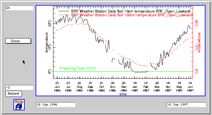
At 10cm subsurface, the soil temperature is at or below freezing (0ƒC) for much of January and February. At 100cm subsurface, the soil temperature never came close to freezing in the 1996-1997 winter. If you put the fence posts down to 100cm, they should be safe from freezing.
Harvester Puzzle #2: A Tent for the Wedding?
Question:
Imagine that your best friends are planning a June wedding at the Black Rock Forest, out behind the Forest Headquarters. They are trying to decide whether to spend the money to lease a big tent. They decide that if the chance of rain is greater than 25%, they will spend the money to rent a tent. Otherwise, they will skip the tent, take their chances with the rain, and spend the money on better quality champagne. The wedding is going to be in the afternoon. In order to line up the tent rental, they need to make this decision two months in advance, so they can't just listen to the TV weather report at the last minute. Based on the historical record of rainfall in Black Rock Forest in previous Junes, what is the chance that it will rain on the wedding?
One route to an answer:
Use the time series capability of the Data Harvester to plot hourly precipitation for the month of June for one year. The fact that the question is posed in terms of time ("June"; "afternoon") is your clue that a time series probably an the appropriate data display strategy. This graph will tell you how many days in June had rain that year, and which days they were.
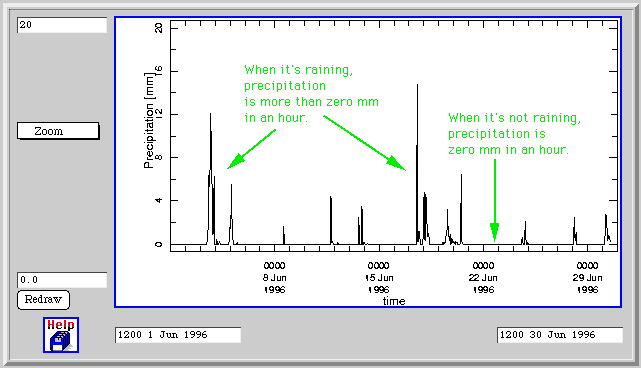
This useful, but we really only care about rain in the afternoon. Use the "zoom" capability of the Data Harvester to zoom in on one of the days that did have rain. On the zoomed display in the illustration below, you can see that there was rain on the afternoon of June 3 (between 12:00and 18:00 hours), but there was no rain on the afternoon of June 4.
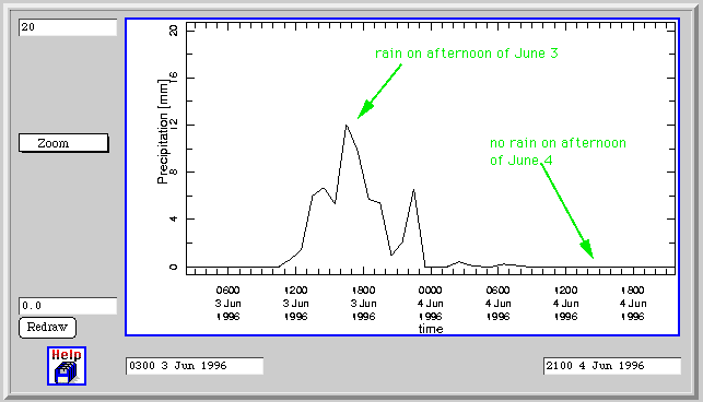
Now, use your browser's "Back" function to return to the time series graph showing the entire month of June. Zoom in on another rainy day. Keep track on a piece of paper of which days had rain in the afternoon.
When you have checked each rainy day, count up the number of rainy afternoons. Divide the number of rainy afternoons, by the total number of days. Is it more than one quarter (25%) of the days? If so, better invest in that tent.
Teaching Note: You may need to review or teach the use of the 24 hour clock before students will be able to complete the second half of this puzzle. Here are some examples:
0000 = midnight
0600 = 6:00 in the morning
1200 = noon
1500 = 3:00 in the afternoon
1800 = 6:00 in the evening
2100 = 9:00 in the evening
2300 = 11:00 at night
Harvester Puzzle #3: Keep the Rare Books out of the Damp
Question:
Imagine that you are planning to site a rare books library at the Black Rock Forest. Moist air harms books, so you wish to select the site with the lower humidity. Which BRF site typically has lower relative humidity?
One route to an answer:
The question asks to you compare two different data sets, and see which of the two kinds of data has a lower value most of the time(lower relative humidity).One very powerful way to make such a comparison is to make a scatter plot, with one data set on one axis and the other data set on the other axis.
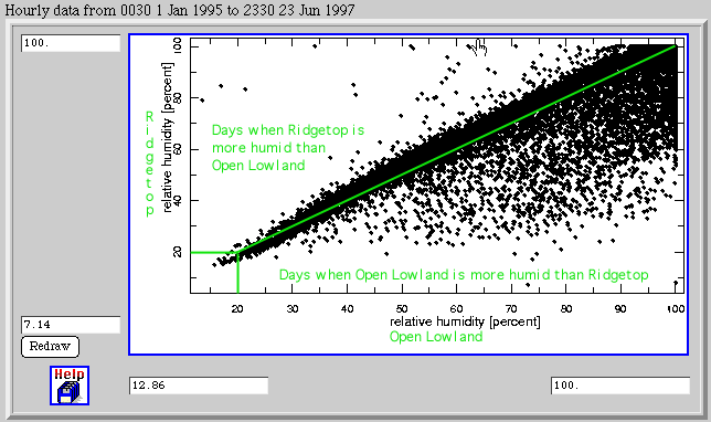
Then draw the 1:1 line, a line connecting point (0,0) with point (100,100). Points on this line represent times when the relative humidity at Ridgetop was exactly equal to the relative humidity at Open Lowland. For times represented by points near the 1:1 line, it doesn't much matter where you build the library; the relative humidity is nearly the same at both locations.
Points above the 1:1 line represent times when the relative humidity at Ridgetop was higher than the relative humidity at Open Lowland. Points below the 1:1 line represent times when the relative humidity at Open Lowland was higher than the relative humidity at Ridgetop.
There are a lot of data points that are well below the 1:1 line. At those times, the Open Lowland site would be much worse for a rare books library than the Ridgetop site. There are only a relatively few data points that are well above the 1:1 line. In conclusion, the Ridgetop Site seems like a better choice for a rare book library, as least as far as protecting the books from humidity is concerned.
Harvester Puzzle #4: The Camping Trip
Question:
Imagine that you are planning a week long camping trip to the Black Rock Forest, in October. What kinds of clothes and equipment should you bring? Use data from the forest to defend your answer.
One route to an answer:
The aspects of the weather that have the most impact on the comfort of a camper are air temperature and precipitation. Campers also care about what time of day the different weather conditions occur. For example, cold air temperature at night, when campers can be in their tents and sleeping bags, calls for different preparation than cold air temperature during the day. So let's plot time series of precipitation and air temperature for the month of October:

There was a significant amount of precipitation on 7 out 31days. We'd better bring rain gear and a weatherproof tent.
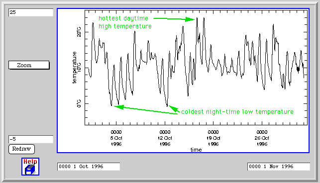
The temperature fluctuated drastically between day and night. A few nights, the temperature reached freezing (0ƒC). So we'd better bring our all-seasons sleeping bags. The day time temperatures are usually around 10ƒC, so we'll need long pants and a sweater. But occasionally, the day time temperature gets well above normal room temperature (20ƒ C), so let's bring shorts and bathing suits just in case...
Teaching Note: You may need to teach or review the Celsius temperature scale before students will be able to interpret the temperature graph in terms of clothing. With mathematically-adept students, you can give them the conversion formula:
ƒF = (9/5 * ƒC ) + 32
For younger children, you can just give them a few key conversions:
0ƒ C = 32ƒ F
5ƒ C = 41 ƒ F
10 ƒC = 50 ƒ F
15ƒ C = 59 ƒ F
20ƒ C = 68ƒ F
25ƒ C = 77ƒ F
Harvester Puzzle #5: Build a Sheltered Patio
Question:
Imagine that you are designing a house to be build at the Ridgetop site of Black Rock Forest. You wish to build a patio on the house, on the side of the house that will be most sheltered from the winds. Which side of the house would experience the least frequent occurrence of strong winds?
One route to an answer:
This puzzle asks you to consider two different kinds of data, and how they interact. A scatterplot is usually a good technique for exploring how two different kinds of data interact.
We want find out if there are certain wind directions where the wind speed is nearly always slow. In other words, we want to look at wind speed as a function of wind direction. Wind direction is our independent variable, so it goes on the horizontal axis. Wind speed is our dependent variable, so it goes on the vertical axis.
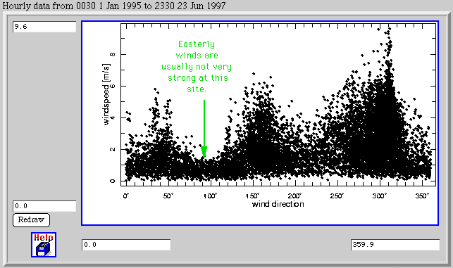
Notice that the strongest winds, those in excess of 7 or 8 m/s, nearly always come from the Northwest (direction approximately 315ƒ). Don't build your patio on that side of the house!
A low dip in the scattered data marks one direction which almost never has strong winds. That direction is 080ƒ-110ƒ; in other words, winds from the east are almost never very strong. Building your patio on the eastern side of the house would be a good plan.
There is one other interesting data display you can make with the Harvester that bears on this problem. In the scatter plot you have just created, seethe third parameter (color) to display air temperature.
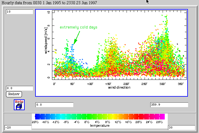
Notice that the warm balmy days, the days on which you're likely to want to use your patio, are shown in reds and warmer colors. Frigid days, on which you won't want to use your patio anyway, are shown in blues and cooler colors. It turns out that those few scattered days on which there was a strongish easterly wind are all freezing days, on which you wouldn't want to sit out on the patio anyway. So your decision to build on the east side of the house is reconfirmed.
Teaching Note: You may need to review or teach the use of numerical compass directions before students can complete this investigation. Recall that there are 360ƒ in a circle. The convention is to call north "zero," and then circle clockwise around through the other compass points, as follows:
000ƒ = north
045ƒ = northeast
090ƒ = east
135ƒ = southeast
180ƒ = south
225ƒ = southwest
270ƒ = west
315ƒ = northwest
Final Note:
At first glance, these Harvester Puzzles may seem a bit contrived. But, in fact, the problems of finding shelter from the rain, the wind, and extremes of temperature are ones that are faced by all the animals that live in the forest. The problem of finding an appropriately humid microenvironment is one that is faced by many species of moisture-loving plants. By learning to think about environmental data when the questions are posed in terms of human problems, students will gain the skills to think about problems in natural systems.
Created by Kim Kastens (1997), Lamont-Doherty Earth Observatory
(kastens@ldeo.columbia.edu).
May be freely used for educational purposes provided appropriate credit is
given.