Anomalous seaward dip of the lithosphere-asthenosphere boundary beneath northeastern US detected using differential-array measurements of Rayleigh waves
W. Menke and V. Levin
PDF Version of paper
Abstract. Rayleigh wave phase velocities and azimuth anomalies in the period range of 30-100 s are measured for a set of four triangular arrays of broadband seismometers in coastal northeastern United States. This is a region in which a strong upper mantle slow shear velocity anomaly (a "New England Anomaly"), crosses the continental margin. Earthquakes from a wide range of directions are used to detect the variation of parameters with azimuth, theta, of propagation. No lateral heterogeneity in phase velocity is detected at these periods between stations at the center and the edge of the Streak. However, large (10-20%) azimuthal variations occur, and have a cos (1 theta) dependence indicative of a dipping structure in the upper mantle. Corresponding azimuth anomalies, with a magnitude of +/- 5 deg, are also detected. This behavior is consistent with a southeasterly (N150E) dip of the lithosphere-asthenosphere boundary beneath New England. This dip is associated with the shoaling of the New England Streak beneath the Adirondack mountains, west of the array. It is opposite to the dip associated with lithospheric thickening toward the interior of the craton.
Introduction The northeastern edge of North America is a "textbook-case" passive margin (Grow and Sheridan, 1988; Sheridan et al., 1995). It was formed during a Mesozoic (0.2 Ga) rifting event that created the Atlantic Ocean, which was associated with voluminous mafic magmatism (see a review in Mahoney and Coffin, 1997). It has experienced very little subsequent tectonic activity, the most significant event being the passage of the hot spot that formed the New England sea mounts in the Cretaceous at 0.1 Ga (Sleep, 1990) (Figure 1).
The eastern half of the North American continent consists of sequence of tectonic terranes that were progressively accreted to the central Archean craton during the last 3 Ga. The Grenville province (Moore, 1986) formed at 1.2 Ga following the closure of a Proterozoic ocean basin. It separates the central craton from the younger (0.3-0.4 Ga) terranes of the Appalachian Orogen that were accreted during the closure of the Iapetus ocean during the Paleozoic (Taylor, 1989).
A general thinning of the continental crust from 45-50 km at the center of the craton to about 35 km at the coast to 15-20 km on the continental shelf is evident from seismic refraction data (Hughes and Luetgert, 1992; Hennet et al., 1991; Keen and Barrett, 1981, also see a compilation by Mooney et al., 1998). The subareal thinning mostly reflects the different provenance of the constituent tectonic units, with terranes that accreted more recently generally having thinner crust. The submarine thinning reflects 40-50% extension during the Mesozoic rifting event that created the present-day Atlantic Ocean (Steckler and Watts, 1978).
A corresponding - though less thoroughly studied - thinning of the mantle lithosphere occurs as well. Upper mantle shear velocity models, based on long-period waveform inversion, show a general decrease in lithospheric thickness (as delineated by mantle shear wave velocity) along a traverse from the craton's center into the eastern Atlantic (Van der Lee and Nolet, 1997). A recent study of mode-converted body waves by Li et al. (personal communication, 2000), provides further evidence of this thinning by identifying an eastward decrease in depth of a velocity interface likely associated with the bottom of the lithosphere.
Seismic velocity under the cratonic North America is systematically faster than the global average, with the maximum of about 6% occurring in the Great Lakes region (e.g., Grand (1987)). Velocities under the eastern North American margin are lower, but the overall pattern is not (as one might expect) margin-parallel. Instead, several smaller-scale (on the order of 400 km) but large amplitude (+/-6%) heterogeneities are present, some of which are elongate and near-perpendicular to the margin (Van der Lee and Nolet, 1997) (Figure 1). Regional P wave, S wave and surface wave tomographic studies show that this heterogeneity persists at smaller scales as well (Taylor and Toksoz, 1979; Levin et al, 1995; Levin et al., 2000; A. Li, personal communication, 2000). Interestingly, the high level of velocity heterogeneity has no corresponding analog in the pattern of shear wave splitting, which is laterally homogeneous (Levin et al, 1999; Levin et al., 2000). The velocity heterogeneity must therefore represent "non-directional" aspects of the mantle structure (composition and/or temperature, not anisotropy).
The most prominent of the margin-perpendicular anomalies is a low velocity streak that Van der Lee and Nolet (1997) map as extending from beneath the NY Adirondack mountains, across New England, to a point at least 1000 km off shore. Its width is variable, but in the 200-500 km range. It is centered at a depth interval of about 100 km beneath the Adirondacks, deepening to 150 beneath the Atlantic (see Van der Lee and Nolet, 1997, their Plates 4 and 5). Its geographical location is roughly coincident with the track of the New England seamounts, leading van der Lee and Nolet (1997) to postulate that it represents a grove eroded into the lithosphere by the passage of the hot spot. This anomaly, which we will subsequently refer to as the "New England Anomaly" (NEA), is also evident in Levin et al.'s (2000) shear wave tomography (see Figure 2) and in Li's (personal communication, 2000) maps of Rayleigh wave phase velocity (although there is only poor agreement on its exact shape).
Imaging techniques, such as the three that have been applied to this region, provide a good overall picture of the lateral heterogeneity. They can, however, suffer from the effects of poor resolution, which can smear features out or project them into incorrect locations. This problem is particularly important with studies carried out on the edges of continents, such as the northeastern North America, because of the lack of seismic stations in the oceans. Furthermore, velocity structure and anisotropy can trade off in complicated ways. Neglecting anisotropy, or assuming, say, a cos(2theta) pattern with constant fast direction (as is commonly done) can lead to artifacts in regions where these assumptions are violated.
In this paper we pursue an alternative to tomography, in which we use small seismic arrays to make local measurements of Rayleigh wave phase velocity and azimuth of propagation. The advantage of such measurements is that they do not involve tomographic reconstruction, and they do not make prior assumptions about anisotropy. The disadvantage, however, is that a separate array is required for each patch of the earth where a measurement is to be made. Fortunately, sufficient numbers of seismic stations have been operated to allow us to examine a swath of coastal northeastern US that overlies the NEA anomaly just west of the coastline.
Our primary findings are that a) Rayleigh waves in the period range of 30 - 100 sec have similar phase velocities throughout the region that covers the center and the edge of the NEA; that b) throughout the region phase velocities display a cos 1 theta dependence on the azimuth of wave propagation, with an amplitude of variation in 10%-20% range; and that c) directions relatively "fast" and "slow" Rayleigh wave propagation are 150SE and 30NW, respectively. From these findings we infer an existence under the northeastern North American margin of the region with anomalous geometry of the lithosphere-asthenosphere boundary, and present arguments for this boundary to be shallowing inland, towards the Adirondack Mountains.
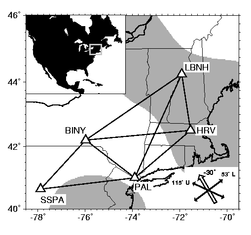
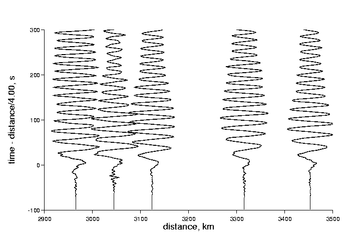
Data Retrieval and Preparation Five seismographic stations (HRV, LBNH, PAL, BINY and SSPA; see table 1) in northeastern US were selected for the analysis, on the basis of their location (east of the edge of the Precambrian craton) and their relatively long interval of operation (at least 5 years). Broadband vertical-component data from 35 earthquakes, most having magnitudes greater than MS>=6, and with a wide azimuthal distribution, were retrieved from the IRIS Data Management Center. Fifteen of these earthquakes (figure 4 and table 2) had sufficient station coverage to be used. The instrument response was removed and the resulting velocity records were demeaned, tapered and windowed to isolate the Rayleigh wave. Record sections were visually inspected to identify and fix sign errors and to delete poor quality seismograms (figure 5). Rayleigh wave phase velocities were then calculated for four triangular arrays of stations, denoted T1 through T4 (figure 3), as described in the next section. Taken together, these measurements sample a region that extends from central Pennsylvania to southern New Hampshire.
Methdology In this paper we make "local" estimates of the phase velocity and direction of propagation of the Rayleigh wave using triangular arrays of seismometers (Priestley and Brune 1978). The measurements are local in the sense that the scale length over which they are made (typically 100-200 km) is smaller than the wavelength of the Rayleigh waves (200-400 km for 50-100 s waves). Diffraction averages out the effect of small scale heterogeneity within (and near) the array. Thus the array senses the net movement of a patch of the Rayleigh wavefront.
The first step in making the local estimates is to compute the frequency-dependent differential traveltime, Delta-T_ij(omega), of the Rayleigh wave between two nearby stations, i and j. We assume that we have a vertical-component velocity seismogram, s_i(t), that has been tapered to remove body wave phases and windowed to start just prior to the onset of the Rayleigh wave, at a time tau_i after the origin time of the earthquake. The Fourier transform of the windowed seismogram is s_i(omega) = A_i(omega) exp{ i phi_i(omega) }, where A is amplitude and phi is phase. The differential traveltime of the Rayleigh wave is then $Delta T_ij = (tau_i - tau_j) - (phi_i(omega) - phi_j(omega)) /omega. The differential phase, Delta phi_ij = (phi_i(omega) - phi_j(omega))$ can conveniently be computed by cross-correlating the two seismograms, since the Fourier transform of s_i(t) * s_j(-t) is proportional to exp{ i Delta phi_ij }. The use of the cross-correlation also reduces the effort needed to unwrap the phase measurement.
The second step is to make a local estimate of phase velocity (and possibly also the azimuth) of the Rayleigh wave using differential traveltimes from several pairs of stations. The simplest strategy is to assume that the azimuth of propagation is approximately given by the azimuth of the great circle connecting hypocenter to the center of the array. Then the differential phase is Delta T_ij = p(omega) (r_j - r_i), where p(omega) is phase slowness and r_i is the great circle distance between the hypocenter and station i. Only one measurement of differential traveltime (i.e. two stations) is needed to solve for the phase velocity, v(omega) = 1 / p. This estimate will be biased upward, however, if lateral refraction of the Rayleigh wave due to heterogeneities along its path causes it to arrive off-azimuth. The true azimuth can be estimated directly by assuming that the that the wavefront is locally linear, so that the differential traveltime between two stations, Delta T_ij = p(omega) dot Delta x_{j, where p(omega) is the phase slowness and Delta x_ij is the great circle distance between the two stations. Two pairs of differential phase measurements (i.e. three stations) are needed to solve for the two unknown components, p_x and p_y, of the phase slowness. The phase velocity, v(omega) is then given by 1/v(omega) = sqrt{ p_x^2 + p_y^2 } and the azimuth of propagation by theta(omega) = arctan (p_x / p_y).
However, if the stations are too close to the epicenter of the earthquake, the curvature of the wavefront, which is unaccounted for in the above method, can bias the estimates of phase velocity and azimuth. Furthermore, if the stations are hundreds of kilometers apart, the curvature of the earth must be accounted for as well. We handle this problem by fixing the curvature of the wavefront to its great-circle value but allowing its phase velocity and azimuth to vary. Differential traveltimes from three stations, and distances computed on an elliptical earth, are then used to find the best fitting values. This approach is only approximate, since the same lateral heterogeneity that causes the Rayleigh wave to arrive off-azimuth will perturb its curvature. However, as the observed azimuth anomalies are typically small (<= 5 deg), the error in the approximation is negligible.
Since two data (two differential phase measurements) are used to estimate two parameters (two components of horizontal phase velocity), the data can be fitted without error. Thus formal error estimates cannot be provided. However the stability of the slowness estimates with frequency provide an informal measure of error, since we expect that the phase velocity varies only slowly with frequency. This expectation is in general met with our data (see figure 6), at least for periods in the 30-100 second range.
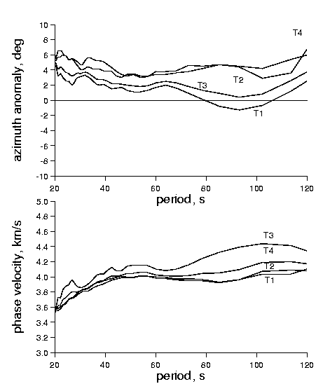
Phase Velocity Observations The measured phase velocities generally increase with period, following a pattern characteristic of dispersion in a continental setting (figure 6). Azimuth anomalies are calculated with respect to the azimuth of the great circle connecting the earthquake epicenter to the center of the triangle and using the fixed-curvature method. We observe no significant overall bias about an azimuth anomaly of zero (ie. the mean anomaly for all events and triangles is very nearly zero). However the magnitude of the typical anomaly grows as period decreases, from about 3 deg at 100 s to about 15 deg at 25 s. This trend likely reflects lateral refraction of the Rayleigh waves due to variations in crustal thickness, whose effects are most pronounced at shorter periods.
We concentrate now on the 30-100 s period range, which is sensitive to the shear velocity of the upper several hundred kilometers of the mantle. The variation of phase velocity with azimuth is considerably stronger than its variation between the four triangular arrays (its variance with azimuth is larger than its inter-array variance by a factor of 2.1). The azimuthally-averaged phase velocity in the 75-100 s period range is 4.06 km/s, with a standard deviation (between triangular arrays) of only 0.06 km/s, or 1.5 percent. Such a low degree of heterogenity is surprising given the significant upper-mantle heterogeneity that has been detected by other methods (e.g. body wave tomography, Levin et al. 2000). On the other hand, the wavelengths involved are very long (120-400 km), so it is possible that the homogeneity arises mainly from the wavefield smoothing effect.
Even more surprisingly, the measured phase velocity is a strong function of azimuth, with propagation to the northwest (i.e. events from the southeast) having a phase velocity that is significantly slower than propagation to the southeast (i.e. events from the northwest) (figure 7). The magnitude of this difference is about 20% at a period of 100 s, and declines to about 10% at 30 s period.
The phase velocity varies strongly with azimuth, theta, of propagation with a very strong cos(1 (theta-theta_0))$ component (with $theta_0 = N150E). We interpret this behavior as being caused by the Rayleigh wave phase velocity being perturbed by a dipping structure in the lithosphere.
The effect of a dipping structure on the propagation of body waves is well-understood, because it can be easily modeled with ray theory (see, for example, Lay and Wallace, Box 3.2, 1995). A wave propagating in the up-dip direction experiences a steeper velocity gradient than it would in a vertically stratified medium. Its horizontal phase velocity is therefore perturbed to higher values. Conversely, propagation in the downdip direction causes a perturbation to lower a horizontal phase velocity. The overall pattern of variation with azimuth of propagation varies as cos(1 (theta-theta_0)), where theta_0 is the updip direction.
Assessing the effect of a dipping structure on a surface wave requires a more complicated analysis (e.g. numerical modeling; see Smith 1974). Nevertheless, the fundamental physical principle of the phase velocity being perturbed to higher values in the updip direction is the same in both the body and surface wave cases. Bullen and Bolt (Section 12.3.3, 1985) describe the result of a numerical calculation for fundamental-mode Love waves interacting with a dipping boundary. As the waves propagate updip, the effect of the phase velocity perturbation is to cause forward scattering into higher modes (which, for a given frequency, have a faster phase velocity than the fundamental mode). An array of seismometers placed above a dipping boundary cannot discriminate between the several modes. Instead it detects an overall phase velocity that is somewhat faster than in the vertically-stratified case.
Although only the Love wave case appears to have received attention in the literature, we expect a similar result to hold for the Rayleigh waves that we study here. We note that while the observed cos(1theta) azimuthal behavior of the phase velocity is consistent with a dipping structure, it is not consistent with that expected from the anisotropic variation of wave speed, which has cos(2theta) and cos(4theta) components.
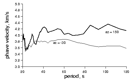
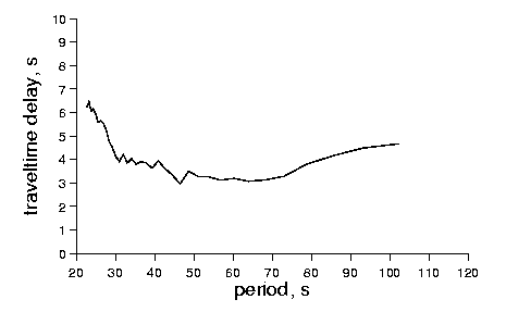
The azimuths of the slow and fast directions are about -30 +/- 10 deg and 150 +/- 10 deg, respectively. Average dispersion curves for these two directions are shown in figure 8. The slow-direction dispersion curve is particularly interesting, because it has reverse dispersion for periods greater than about 60 s. Unfortunately, while the precise velocity structure implied by the dispersion curves in figure 6 is of great interest, we know of no inversion procedure that can properly account for strong lateral gradients in structure.
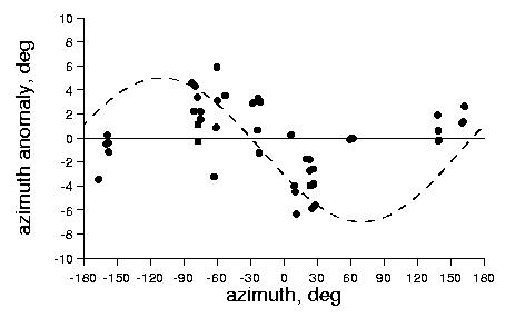
The azimuth anomaly measurements (figure 9) are consistent with the inferred dipping structure, especially in the 75-100s period range which is least sensitive to crustal heterogeneity. The lateral gradient (i.e. a change from slower to faster phase velocities) causes an azimuth anomaly because the Rayleigh wave propagation direction tends to curve away from the direction of maximum lateral velocity gradient (figure 10). Propagation exactly parallel (or antiparallel) to the lateral gradient has a zero azimuth anomaly. Propagation at other azimuths have either a positive or negative anomaly, depending upon the side of the gradient direction they are on. This antisymmetric pattern is clearly detected in the data around the the -30 deg direction. Insufficient data are available to confirm the pattern for the 150 deg case.
We would expect that the azimuth anomalies would also be detectable through measurement of the azimuth of Rayleigh wave particle motion (e.g. by using the multitaper spectral estimation technique of Lerner-Lam and Park, 1989). However, successful application of that technique requires both very accurate calibration of the horizontal seismometer responses and seismograms especially selected to avoid the interfering effect of Love waves (which have large horizontal motions in the relevant period range). Thus we have not pursued such measurements here.
Interpretation and Conclusions Our observations indicate that the Rayleigh wave phase velocity in the Northeastern US exhibits a lateral gradient that points towards the southeast (towards the coast). This behavior is precisely the opposite of what one would expect for a "normal" continental margin, where the lateral velocity gradient would be expected to point into the cold interior of the craton (i.e. seismically faster lithosphere within the craton). It is, however, exactly the signal expected from the New England Streak, and especially from the slow shear velocities beneath the Adirondacks.
The along-coast extent of the region in which which we detect the cos(1theta) phase velocity variation is wider, by a factor of at least two, than the NEA. To some degree, this difference may reflect the lateral averaging of the long-period Rayleigh waves and the choice of reference models by which the velocity anomaly is defined. But it may also indicate that NEA is wider than has hithertofore been recognized.
The October 5 (Julian Day 279), 2000 Mid-Atlantic Ridge earthquake is in a location favorable for detection of the seaward part of the New England Streak, since the path to HRV passes through the center of the oceanic portion of the NEA, while the path to PAL passes along its southern edge. After correcting for the slightly different ranges of the two stations (by applying the dispersion curve measured at triangle 1 to adjust PAL traveltimes), waves at HRV are found to be delayed by 4-5 s with respect to PAL in the 30-100 s period band (figure 9). This delay implies that velocity along the hypocenter-HRV path is about 3% slower than along the hypocenter-PAL path. The delay is consistent with the seaward path of the NEA, as mapped by Van der Lee and Nolet (1997). This measurement demonstrates that the seaward part of the Streak is not an artifact of the tomographic reconstruction. It can be detected using only coastal stations, and by comparing two very similar propagation paths.
These results provide strong evidence that the low shear velocities beneath the Adirondacks extend continuously across New England to connect to a somewhat deeper low velocity anomaly offshore. The alternate interpretation, that these are two distinct anomalies that have been smeared together by the tomography, is discounted.
The NEA cross-cuts the continental margin, indicating that it postdates the 200 ma opening of the Atlantic ocean. Shear wave splitting studies that use core-converted phases such as SKS indicate that northeastern US has two distinct, laterally homogenous layers of mantle fabric. The shallower layer, about 60 km thick, has a fast axis of N115E, and the deeper layer, about 90 km thick, has a fast axis of N53E (figure 3). The SKS data do not constrain the actual depth of these layers, except to place them above the transition zone (i.e. above 400 km). Orientation of the fast axis in the lower layer is in good agreement with the absolute plate motion of the North American plate, and is likely to represent the present-day strain in the asthenosphere. Consequently, Levin et al. (1999) argued that the top layer of fabric has to be within the consolidated mantle lithosphere of the North American continent.
The NEA does not disrupt (or otherwise alter) either of these layers. The splitting measurements are based on relatively short period (<5 s) measurements and sample a relatively small patch of mantle (<50 km) beneath each seismic station. Thus the smoothing of lateral variations by wavefield diffraction cannot explain the homogeneity of the splitting measurements. They imply a real homogeneity of anisotropic fabric that extends from the center of the NEA in Massachusetts to its edge in southern New York.
One possibility is that the anisotropic layers are at different depths in the mantle than the low shear velocities associated with the New England Streak. The data do not preclude the upper layer being wholly above the Streak, and the lower layer being wholly below it (or, alternatively, both layers being below it). Indeed, the absence of any cos 2theta or cos 4theta variability in Rayleigh wave phase velocity, at least in the 30-100 s period range, strongly suggests that the 100-200 km depth interval is not strongly anisotropic.
Another possibility is that the anisotropic layers represent a strain event that is superimposed upon the NEA and its surroundings, and thus postdates it. This scenario would argue against the upper layer having anything to do with the Appalachian Orogeny. Except for the hot spot that created the New England Seamounts, and present-day plate motions, no major post-rifting strain events have been reported for this region.
We discount the possibility that the NEA is the cause of either layer of anisotropy. First, the layers extend over a wider geographical region than the Streak. Second, the axis of the Streak, measured from Van der Lee and Nolet's (1997) map, is about N135E, significantly different from anisotropic symmetry axes within either of anisotropic layers. Mantle flow along the axis of the Streak would not give rise to either fabric. Indeed, we feel that the general lack of any anisotropic signal associated with the Streak argues against its being due to flow of the asthenosphere into a groove in the lithosphere left by the New England hot spot. Such flow would need to be occurring for the past 0.1 ma in order to counteract the conductive cooling of this shallow asthenosphere. Certainly there is no geologic evidence for post-Cretaceous thermal subsidence of this region.
In summary, this work contributes further evidence for the existence of the NEA, a major shear velocity anomaly in the upper mantle, and supports the hypothesis that it cross-cut the continental margin of northeastern North America. However, it only adds to the mystery of the anomaly's origin. The seaward dip of the base of the lithosphere from its shallowest point beneath the Adirondack mountains is clearly detected by the azimuthal variation of Rayleigh wave phase velocities and azimuth anomalies. However, no comparable anisotropic signal is present, such as might be associated with irregularities in asthenospheric flow in and near the Streak.
Finally, these results have implications to the conduct of regional Rayleigh wave inversions in which the station spacing is as fine as the 100-200 used in this paper. At these scales, we have shown that dipping structures can have a very strong effect on Rayleigh wave phase delays, which are the dispersive equivalent of traveltimes. (At larger scales, the effect of a wave's crossing both updipping and downdipping structures probably averages out). Furthermore, the pronounced cos 1theta behavior is at variance with standard tomographic reconstruction techniques that assume that antiparallel paths are equivalent. Modifications to the inversion algorithm to explicitly account for these effects are likely to significantly improve the reliability of the images.
Acknowledgements This research was supported by the NSF grant EAR-9805206 (VL). Aibing Li kindly provided preprints of her work prior to publication, and Susan van der Lee supplied a subset of the NA95 model. Helpfull reviews by Susan van der Lee and an anonymous reviewer are appreciated. We used GMT software [Wessel and Smith, 1991] to prepare some figures.
References
Bullen, K.E. and B. Bolt, An introduction to the theory of seismology, Fourth Edition, Cambridge University Press, Cambridge, 1985.
Grand, S. P., Tomographic inversion for shear velocity beneath the North American Plate, JGR 92, 14065-14090, 1987.
Grow, J. C Bowin, and D Hutchinson, The gravity field of the US Atlantic continental margin, Tectonophysics 59, 27-52, 1979.
Grow, J, and R Sheridan, US Atlantic Continental Margin: A typical Atlantic-type or passive continental margin, in The Geology of North America I-2, R Sheridan, ed., Geol. Soc. Am. 1-12, 1988.
Hennet, C, J Luetgert, and R Phinney, The crustal structure in central Maine from coherency processed refraction data, J. Geophys. Res. 96, 12023-12037, 1991.
Hughes S, and J Luetgert, Crustal structure of the southeastern Grenville province, northern New York and Eastern Ontario, J. Geophys. Res. 97, 17455-17479, 1992.
Keen C, and D Barrett, Thinned and subsided continental crust on the rifted margin of eastern Canada, crustal structure, thermal evolution and subsidence history, Geophys. J. R. Astr. Soc. 65, 443-465, 1981.
Lay, T. and T. Wallace, Modern Global Seismology, Academic Press, San Diego, 1995.
Lerner-lam, A. and J. Park, Frequency-dependent refraction and multipathing of 10-100 second surface waves in the western Pacific, Geophys. Res. Lett 16, 527-530, 1989.
Levin, V., A. Lerner-Lam, and W. Menke, Anomalous mantle structure at the Proterozoic-Paleozoic boundary, GRL 22, 121-124, 1995.
Levin, V., W. Menke, and J. Park, Shear wave splitting in the Appalachians and the Urals: A case for multilayered anisotropy, J. Geophys. Res. 104, 17975-17987, 1999.
Levin, V., W. Menke and J. Park, No regional anisotropic domains in the northerneastern U.S. Appalachians J. Geophys. Res. Vol. 105 , No. B8 , p. 19,029, 2000.
Mahoney, J, and M Coffin (eds), Large igneous provinces : continental, oceanic, and planetary flood volcanism, Geophysical monograph 100, American Geophysical Union, 1997.
Mooney, W. D., G. Laske and T. G. Masters, Crust 5.1: a global crustal model at 5x5 degrees, JGR 103, 727-747, 1998.
Moore, J.M., Introduction: The Grenville Province then and now, Can. Geol. Assoc. Spec. Pap., 1, 1-11, 1986.
Priestley-K; Brune-J-N, Surface waves and the structure of the Great Basin of Nevada and western Utah, Journal of Geophysical Research, A, Space Physics.83; B5, Pages 2265-2272. 1978.
Sheridan, R., D. Musse, S. Holbrook, L. Glover, Mid-Atlantic Coastal Plain and continental margin; basement and mantle structure and continent-ocean transition, in Centennial continent/ ocean transect. 19; 1995.
Sleep, N., Monteregian hotspot track: A long-lived mantle plume, JGR 95, 21,983-21,990, 1990.
Smith, W.D, A non-reflecting plane boundary for wave propagation problems, J. Computational. Physics 15, 492-503, 487, 1974.
Steckler, M and A Watts, Subsidence of the Atlantic-type continental margin off New York, Earth and Planet. Sci. Lett. 41, 1-13, 1978.
Taylor, S. R., Geophysical framework of the Appalachians and adjacent Grenville Province, in Geophysical Framework of the Continental United States}, edited by L.C. Pakiser and W.D. Mooney, Mem. Geol. Soc. Am., 79, 317-348, 1989.
Taylor, S. R., and M. N. Toksoz, Three-dimensional crust and upper mantle structure of the northeastern United States, JGR 84, 7627-7644, 1979.
Van der Lee, S. and G. Nolet, Upper mantle S velocity structure of North America, JGR 102, 22,815-22,838, 1997.
Wessel, P., and W. H. F. Smith, Free software helps map and display data, EOS 72, 441, 445-446, 1991.
Figures
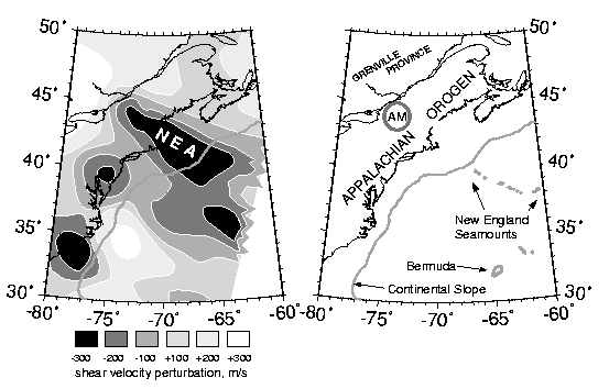
Figure 1. Shear wave velocity anomalies 100 km beneath the eastern North America passive margin (adapted from Van der Lee and Nolet, 1997). Right: Tectonic units of the eastern North America passive margin. A depth contour of 2000m (shaded) outlines the edge of the continent. AM - Adirondack Mountains. (Postscript and PDF).
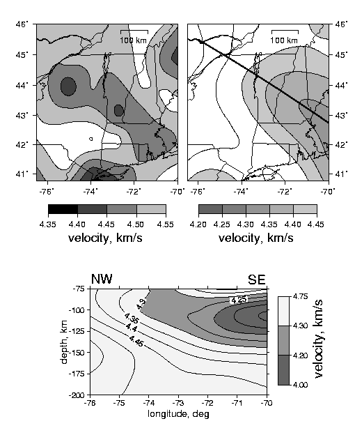
Figure 2. Regional variations in shear wave speed at 150 km depth, as imaged by body wave tomography with S and SKS waves (Levin et al., 1999). top left and Raleigh wave tomography (Van der Lee and Nolet, 1997) top right. Solid line on the right panel indicates the trace of the crossection shown below. There is a general aggreement in the trend of the low velocity features despite large differences in sampling and vastly disparate scales of these studies (body waves - the region shown, Rayleigh waves - continent-wide). lower panel: Vertical crosssection through NA95 model of Van der Lee and Nolet, 1997. Note an "uplift" of velocity contours towards the interior of the craton. (Postscript and PDF).
Figure 3. Map of broadband seismic stations (triangles) in northeastern US used in this study. The stations are grouped into four triangular three-station arrays that are used to make local measurements of Rayleigh wave phase velocity, as follows: (1) PAL-BINY-HRV; (2) PAL-SSPA-BINY; (3) PAL-HRV-LBNH; (4) BINY-HRV-LBNH}. Shading shows an area of NA95 model (Van der Lee and Nolet, 1997) where shear wave velocity is below 4.35 km/s at 100 km depth. Orientations of anisotropic symmetry axes in two layers of mantle fabric (Levin et al., 1999) are shown by solid arrows ( U - upper; L - lower). An open arrow shows the shallowing of the lithosphere-asthenosphere boundary towards 30 deg NW inferred in this study. (Postscript and PDF).
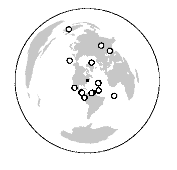
Figure 4. Map of earthquakes (circles) used in this study. (Postscript and PDF).
Figure 5. Vertical component record section, reduced to 4.0 km/s, of Rayleigh waves from a mid-Atlantic ridge earthquake observed on broadband stations in northeastern US. The event occurred on October 5 (Julian Day 279), 2000. The seismograms, in order of increasing range, are from HRV, LBNH, PAL, BINY and SSPA. (Postscript and PDF).
Figure 6. Local estimates of azimuth anomaly (with respect to the great circle) and phase velocity for four triangles in northeastern US to a single earthquake on the mid-Atlantic Ridge. The event occurred on October 5 (Julian Day 279), 2000. (Postscript and PDF).
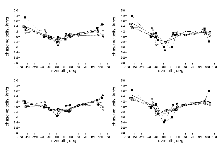
Figure 7. Left Variation of the average phase velocity in the 33-50 s interval with azimuth for four trianges of stations in northeastern Top, Calculation with azimuth anomaly fixed at zero; Bottom, calculation with fixed wavefront curvature and variable azimuth. Each symbol represents a single earthquake observed on a single triangle of stations (black circles, T1; black squares, T2; grey circles, T3; grey squares, T4; see Figure 3 for triangle definitions). The bold curve is a smooth polynomail fit to all the data. Right Same for period range 75-100 s. (Postscript and PDF).
Figure 8. Phase velocity as a function of frequency for the anti-parallel azimuths of -30 +/-15 deg and 150 +/- 15. Data for all events in these azimuth ranges recorded by all four triangles have been stacked. Note the large difference in phase velocity for waves traveling in opposite directions. (Postscript and PDF).
Figure 9. Variation of the azimuth anomaly (with respect to the great circle) in the 75-10 s interval with azimuth for trianges of stations in northeastern US. Calculation with fixed wavefront curvature. Each symbol represents a single earthquake observed on a single triangle of stations. Dotted curve is a best-fitting cos 1theta curve. (Postscript and PDF).
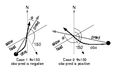
Figure 10. A lateral gradient (i.e. a change from slower to faster phase velocities) in velocity structure (dashed vector) is associated with a pattern of azimuth anomalies that are antisymmetric about the azimuth of the vector (here 150 deg). The direction of propagation of the waves curves away from the faster velocities (bold black curve), leading to an observed azimuth that is different than the one predicted on the basis of the great-circle path (bold gray line). The sign of the azimuth anomaly is different for sources on the two sides of gradient vector direction. (Postscript and PDF).
Figure 11. Differential traveltime between HRV and PAL for a Rayleigh wave from the Oct. 5, 2000 Mid-Atlantic Ridge earthquake, after a correction that adjusts the two stations to the same source-receiver range. The delay of arrival at HRV by about 4 s refects propagation along a path that is about 3% slower than the path to PAL, an amount consistent with path to HRV being through the center of the New England Anomaly and the path to PAL being along its southern edge. (Postscript and PDF).