INTRODUCTION
This proposal addresses the quantification of volcanic hazard and the risk that this hazard poses to human populations around the world, using statistical methods that are broadly similar to those employed for earthquakes (e.g. Cornell, 1968; Benjamin and Cornell, 1970; Schenk, 1996) and storms (e.g. Barton 1995). The word "hazard" has a very specific meaning in this context, and refers to the specific repercussions of an event that can potentially cause damage at a specific place . Earthquakes cause a ground shaking hazard that can be quantified by the peak ground acceleration that a place experiences (Frankel et al. 1996; Petersen et al. 1996). Similarly, storms cause a wind hazard that can be quantified by peak wind velocity that a place experiences.
Volcanic eruptions include a number of dangerous processes, such as ash falls, degassing, explosions, lahars, lava flows, pyroclastic flows, and tsunamis, each of which gives rise to one or more types of hazard. However, relatively little work has been done to enumerate and quantify these hazards. For instance, the degree to which the strength of a lahar hazard can be usefully quantified by the thickness of the layer of flowing mud and its velocity has not been fully established. Indeed, some very good assessments of lahar hazard for specific volcanoes (e.g. Del Pozzo et al.'s 1995 map for Colima Volcano) provide only regionalized estimates of the frequency of lahars, without regard to their severity. On the other hand, improvements in quantitative models of the dynamics of lahars (Iverson et al., 1998, Schilling, 1998, Hayashi, 1992) may provide better ways of quantifying their hazard as well.
Even the relative importance of different hazards is arguable. Pyroclastic flows, tsunamis and lahars have caused the most loss of life in the last 150 years. However, each of them is associated with exactly one large, damaging eruption (Mt Pele, Krakatau and Ruiz, respectively) - a less than satisfactory statistical sample. More importantly, this anecdotal approach fails to distinguish between hazard (the physical repercussions) and loss (the damage caused by the repercussions). Yet as patterns of habitation, land-use and construction change, a specific type of hazard may gain or lose importance. For instance, many more major highways, pipelines and electrical transmission lines now cross volcanic mountain belts than fifty years ago. The types of hazard which could cause loss to such structures are different than those that would effect, say, rural villages. The type of loss - economic as contrasted to human life - is different, too, and may require a more quantitative approach.
Much excellent work has gone into assessing the hazard of individual volcanoes, especially in the context of the region immediately surrounding them. While there is nothing fundamentally wrong with this approach, it is limited by the degree of attention that can be paid to each of the several thousand known Holocene-active volcanoes. Typically, the most recently active volcanoes are the ones to which individual attenion is paid. On the other hand, there are many damaging eruptions that occur on volcanoes (e.g. Pinatubo) that had had little or no historic activity, and which were therefore deemed to have little or no hazard. The problem is that the characteristic time between a volcano's largest eruptions may well exceed 10,000 years - longer than all of recorded history. This behavior suggests that a statistical approach to assessing volcanic hazard that treats all Holocene volcanoes as potentially damaging may be a useful complement to individual volcano assessments.
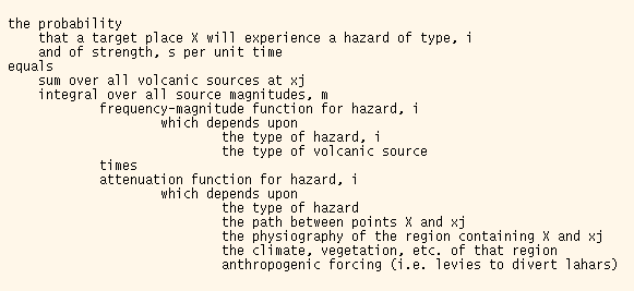
Probabilistic hazard analysis requires knowledge of three important distributions: 1) the spatial distribution (including elevation) of "sources" of hazard; 2) the frequency-size distribution of the magnitude of the source of the hazard, 3) the "attenuation law", meaning the conditional probability that a given "target" region will experience a hazard of a given strength, given a source of specific magnitude and location. The total hazard is computed schematically as:
The areal distribution of Holocene-active volcanoes is fairly well-known, and is available through compilations such as Simkin and Seever (1994). Furthermore, the lava chemistry (i.e. basaltic, andesitic, etc.), which is important for some hazards, is known for many of them.
Recent research has established that the volcanic processes obey a power-law frequency-size distribution (Dubois and Cheminere, 1991; Simkin, 1993; Pelletier, 1999). For instance, Simkin (1993) shows that the VEI obeys such a law with an exponent of around 1, and Pelletier (1999) shows that the area of basaltic flows obeys such a law with an exponent of around 0.8. However, some work needs to be done to quantify the relationship between the particular measured process and the source of hazard. For instance, VEI is not the same as force-moment, which would be the proper physical measure of the size of an explosion. Likewise, lava area is not the same as lava volume, which would be the proper physical measure of the size of a lava flow.
Following the seismological usage, we use the term "attenuation law". We must recognize, however, that its behavior may be more complex than in seismology, where the shaking hazard is generally taken to decline monotonically with distance from the hypocenter. A good tsunami hazard attenuation law, for example, would almost certainly include factors such as the distance of the volcano source from the coast and the depth of water between source and target. A lahar hazard attenuation law would almost certainly include some measure of whether the source was "downstream" from the target. A key part of this project will be developing an attenuation law for each of several volcanic hazards, and testing each one against observations, drawn from both the literature and from remotely sensed imagery (satellite, shuttle and aerial)
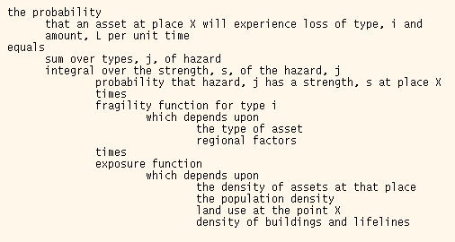
Once the hazard probability has been quantified, it can be used in a probabilistic estimate of the loss of some asset (meaning anything of value to people - lives, dollars, time, etc.) (Cao et al., 1999). Two new distributions are needed: 1) exposure, which quantifies how much of a particular asset is exposed and 2) fragility, which quantifies how a susceptible an asset of a given type is to damage from a hazard of a given strength. Schematically:
PROPOSED WORK
1. Define a set of workable physical quantities to describe the strength and source of several different kinds of hazards, including ash fall, degassing, explosion, jokullups, lahar, landslide, lava flow, pyroclastic flow, and tsunami. Some of these quantities - using tsunami wave amplitude to quantify tsunami hazard, for example - are already well-established in the literature. Others will require experimentation, to find a workable parameterization that has both a sound physical basis and has a chance of being backed up with available data.
2. Design size-frequency distribution and hazard attenuation functions for each type of hazard. This work will rely on both analysis of existing published results and, in the case of tsunamis and pyroclastic flows, on new analyses of remote sensing data. Our aim here is to produce simple but numerical formula (with error estimates!) that, while preliminary, nevertheless give useful results when used in the hazard calculations. We discuss some of the issues that arise for a few of these hazards, below:
A. Landslides. Volcanic landslides are just a special case of landslides in general, and result from slope instabilities that develop as the volcanic edifice is built up. Thus much of the literature of ordinary landslides (e.g. Slosson et al., 1992; Brabb and Harrod, 1989) is applicable to understanding their general behavior. For instance, techniques for using DEM's to assess slope stability [Stark and Weissel, 1996] could be used to identify which volcanic edifices are particularly vulnerable. Volcanic landslides are often associated with eruptions, but are not limited to times of volcanic activity. Considerable work has been done on identifying specific volcanic landslides and in identifying some of their statistics. For instance, Siebert et al. (1987) and Pierson (1995) has quantified their size distribution and the relationship between their height, volume and run-out. However, as far as we know, there do not seem to be any published estimates of the frequency of occurrence of volcanic earthquakes. Thus we propose to develop a new frequency-size distribution function for volcanic landslides, using repeat satellite imagery to detect landslides on representative suite of volcanoes. This approach has been successful for earthquake-related landslides in New Zealand, New Guinea and elsewhere (Hovius et al. 1997; Weissel and Stark, personal communication, 1999; see also http://geomorph.ldeo.columbia.edu/slides/).
B. Tsunami. Sea waves can be generated by several mechanisms: by displacement of the sea floor by faulting during an eruption; by landslides and pyroclastic flows rolling onto and displacing the sea surface and by underwater explosions). Little information on the frequency-size distribution of volcano-related tsunamis is available, owing to their rather infrequent occurrence (only about 40 volcanoes are known to have produced volcanoes) and to their poorly documented wave heights. We thus propose to estimate the rate of tsunamis by analyzing the rate of each of the underlying source mechanisms. For instance, volcanic earthquake frequency-size distributions (i.e. Gutenburg-Richter "b-values") can be determined from the very good seismicity catalogues, such as the ISC catalogue, that are available. These statistics, together with the volcanoes proximity to the sea, can then be used to infer the rate of sea-floor faulting. Tsunami-source frequency-size statistics can then be inferred by the fault frequency-size statistics. Similarly, the frequency-size distributions of landslides, pyroclastic flows and explosions can be used to infer the frequency-size distribution of the corresponding tsunami source (Heinrich, et al., 1998).
Considerable progress has been made in modeling the propagation of the tsunami across the ocean (e.g. Titov and Gonzalez, 1997). Thus development of tsunami attenuation laws will be very straightforward.
C. Lahar. Lahars require a source of water (e.g. crater lakes, melting snow or glaciers, large storms), a source of rock particles (e.g. the volcano edifice, pyroclastic flows, etc. and the right morphology (e.g. valley heads) to occur. The Lahar flow process has been intensively studied and modeled (Iverson et al., 1998, Schilling, 1998, Hayashi, 1992). Thus we do not see the development of an attenuation law as a problem. On the other hand, the frequency-size distribution for lahars seems very poorly known. We propose to approach it from two prespectives: direct observation of lahars from a suite of repeat imagery, as described above for landslides; and estimation of the rate by inferences made from the rate of the underlying triggering mechanisms. The rate of storms is known from meteorological data. The breaching of crater lakes is essentially a slope-stability issue, so that the frequency-size distribution for landslides can be used to estimate how often they fail. It is possible to estimate the amount of heat associated with an eruption of a given size, so that VEI statistics can be used to infer glacier-melting statistics.
D. Pyroclastic flow. Pyroclastic flows present themselves as two distinct hazards; (1) emplacement of hot, ejected material, creating a hazard that can be measured as a thickness and extent of deposit, and (2) secondary mobilization of the emplaced mass which in turn mobilizes material beneath it (e.g., glaciers, snow cover, recent ash fall) and in it's path (all material down slope). Due to these distinct manifestations of hazard, it is necessary to determine the volume of ejected material (and properties of the source region) and the volume of effected material (ice thickness, crater lakes) to fully characterize the threat. Similar to lahars, the pyroclastic flow process has been intensively studied and modeled (Hayashi and Self, 1992, Pierson et al, 1990, Rossano et al., 1996, Cole et al, 1998 Wadge et al, 1998). Thus again we propose to approach the problem from two perspectives: direct observation of pyroclastic flows from a suite of repeat imagery, as described above for landslides; and estimation of the rate by inferences made from the rate of the underlying triggering mechanisms (edifice building, earthquake swarms). The VEI statistics will be used to infer the heat of the pyroclastic blanket. This will then allow derivation of glacier-melting and mobilization statistics.
3. Produce probabilistic hazard maps for four specific regions: Java, Central America, New Zealand and Iceland. These regions have been chosen because they span a range of different volcanic terrain types (e.g. arcs, hot spots) and because good DEM's, climate records and population maps are available for them.
4. Design fragility functions for several important assets, including human lives, several classes of buildings, agricultural production and lifelines such as pipelines, highways and electrical transmission lines.
5. Produce probabilistic loss maps for the four regions. (need more here).
6. Make predictions the way that the volcanic risk might change in the next 50 years, due to anticipated growth in world population and changing patterns of land use. (need more here).
CORONA IMAGERY FEASIBILITY STUDY
A common problem in volcanic hazard delineation is the lack of descriptive topographic and hazard maps. We assessed the feasibility of utilizing recently declassified, high-resolution (6 ft to 450 ft), satellite intelligence photographs archived by the EROS Data Center. Declassified Intelligence Satellite Photography (DISP, i.e. CORONA, ARGON) extend the time frame of near field quality volcanic hazard analysis to the early 1960s (McDonald, 1997). In addition, these images theoretically provide coverage of the whole globe including areas north of 60N and south of 60S, latitudes rarely covered by contemporary satellites (Paulsen and Wilson, 1998, Bindschadler, 1998; Bindschadler and Vornberger, 1998) and . To address the usefulness of this database, Shiveluch Volcano, the northernmost active volcano on Kamchatka, was chosen.
Mt. Shiveluch erupted on November 11, 1964, swiftly destroying and area of approximately 198 sq km (Belousov, 1995). The edifice failure and explosion occurred at night, allowing for few syneruption observation of the gigantic collapse, pyroclastic flows and mud flows. Auspiciously, pre-and post eruption images with less than 10% cloud cover are available for Shiveluch from the period from November 1963 to March of 1968, closing an important gap in the changing nature of one of Kamchatka's most active volcanoes. By applying edge detection software, areal extents of high contrast pyroclastic flows, avalanche deposits, alpine glaciers and, theoretically, lahar/mud flows, can be quickly processed for the eruption (Lechtenauer et al., 1997, Stocks and Heywood, 1994). Further, the later imagery can address the environment under which a second eruption occurred in 1993 (Dvigalo, 1988, Dobrynin, 1992, Fedotov et al, 1995, Firstov et al, 1995).
Our conclusion is that areal extent of extrusive processes and, in turn, estimates of their temporal frequency and magnitude can be extracted for eruptions from the period from 1960-1972. Theoretically, a pre- and post-eruption analysis can be applied to all eruptions for this decade, and a baseline for post 1972 eruptions can be established.
PROJECT MANAGEMENT AND TIME TABLE
William Menke and Klaus Jacob will jointly manage the project, and be responsible for its successful completion. All personnel will participate in all tasks of the project.
Year 1 will be devoted to the development of hazard frequency-size and attenuation distributions, with GRA Kristina Rodriguez leading the pyroclastic study, Dallas Abbott leading the tsunami study, and Menke and Jacob jointly leading the others.
Year 2 will be devoted to the development of asset fragility functions and the production and interpretation of the hazard and loss maps.
During this course of this research we expect to informally collaborate with a number of groups at Columbia, including Lamont-Doherty's Landslide Group (e.g. J. Weissel and C. Stark), the NASA/SEDAC-funded CIESIN group (known for their population density maps, among other things) and Columbia's Laboratory of Populations.
DISSEMINATION OF RESULTS
To other scientists. We will present the results at appropriate national meetings
and submit them for publication in appropriate journals. We will also maintain "Open
File Reports" on our web site:
http://www.ldeo.columbia.edu/~menke/www_users_menke/
that archive our data, analysis procedures, figures, hazard and risk maps, as we do for other
projects we undertake.
To policy makers. One of us (K.J.) serves on several state and national hazard mitigation committees, and maintains regular contact with policy makers and disaster response personnel in US agencies such as FEMA and elsewhere in the world (e.g. Indonesia).