Spring Break Fieldtrip to the River Valleys
south of Chicago
Bill Menke and Dallas Abbott, March 10-17, 2023
|
|
|
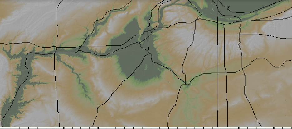
Topographic Map of the Area of the Fieldtrip, Map is about 150 miles wide |
|
|
|
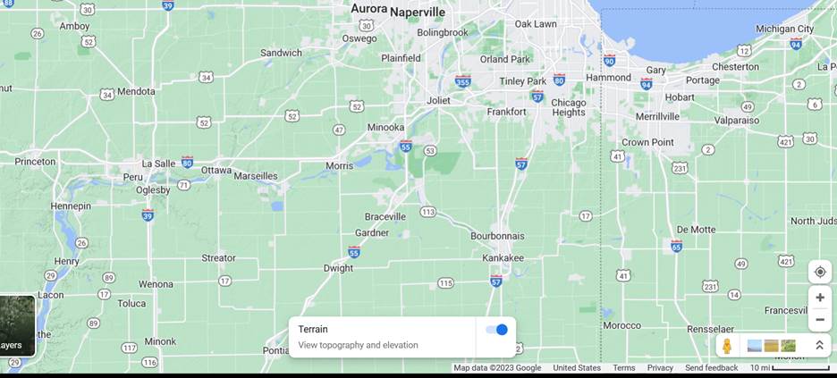
Street Map of the Area of the Fieldtrip, Map is about 150 miles wide |
March 10, 2023, Dallas and I drive from Tappan NY to Wilmette Illinois in about 13 hours, doing a long stretch or our trip on Interstates 80 and 90. The weather is poor, with light to moderate rain and occasional snow flurries. We are staying with cousins Bryan Abbott, James Abbot and Mary Abbott, on Lake Ave in Wilmette, which is one of the northern suburbs of Chicago.
March 11, 2023, grey skies today with temperatures in the low-forties. Bryan Abbott joins Dallas and me on a tour of our study are, the center of which is about an hour's drive south of Chicago, in a region where the DesPlaines, DuPage and Kankakee Rivers converge to form the Illinois River. We are examining a large circular feature, perhaps sixty miles in diameter, that Dallas spotted on a topographic map. The confluence of the rivers is in a broad lowland region at the center of the feature.
Stop 1, Channahon State Park (Channahon, Illinois). We park by a dam on the DuPage River. We cross the dam and walk a path that parallels the I&M Canal, an old barge canal. A few Canada geese are paddling about the still water upstream of the dam. Though we pass some limestone boulders, and can see that the walls of the canals are lined with sandstone blocks, we can find no rock outcrops. We stop to admire an old lock on the canal. Water is cascading down a concrete barrier made to mimic one of the now-vanished wooded gates, making a small waterfall.
Stop 2, McKinley Woods (Channahon, Illinois). The woods are on a highland peninsula cut by many gullies, on the north bank of the DesPlaines River. We park at a lot at the top of the hill and walk a paved road down to the river. We pass some erratic boulders of gneiss, and though we peer to the bottom of several gullies, we can see no rock outcrops. After admiring the river, we hike a short loop on a trail through the woods, passing some ruined buildings at river level, ascending its flank and eventually arriving back at the parking lot. No outcrops are evident.
Stop 3. Big Fish Grille (Wilimington IL). Our lunch spot is a restaurant on the southern bank of the Kankakee River, just a little south of the McKinley Woods, but our path to it is very circuitous, owing to all the streams and ponds in this lowland area. We cross a covered bridge designed to keep away fog from a large cooling pond that is part of the Dresden Energy Center, a nuclear power plant. I spot a Bald Eagle flying over the pond. The restaurant is on the river. We have a relaxing lunch, with me having fish and chips.
Stop 4. Short Pioneer Cemetery Prairie Nature Preserve, Coal City, Illinois. The area south of the rivers is full of the remnants of coal strip mines – a quilt work of elongated ponds with rough wooded terrain between, underlain by mine tailings. We drive around looking for rock outcrops, finding none. We stop at the Nature Preserve, parking beside a small, gated graveyard. We spend a few minutes reading the inscriptions on the grave markers. Most are from the 1860's through 1890's. We then walk a gravel road to one of the strip mining ponds, which has a boat launch at one end. We peer into its waters, looking for rock outcrops, but not spotting any. On the way back to the car, I climb one of the wooded mine waste hills. It is composed of fine but hard sediment, with a lot of cohesion.
Stop 5., Boat Launch on Kankakee River, off Route 113, Wilmington, Illinois. We headed east, following the south bank of the Kankakee River, stopping at a boat launch that offered a good view of the river. Though our bank was flat and muddy, the opposite bank had a tall cliff of stratified rock. We chatted briefly with a group of surveyors who were cleaning their All-Terrain Vehicle in the river.
Stop 6. Kankakee River State Park, Bourbonnais, Illinois. We parked at the lot just west of the Route 85 Bridge. We walked a loop through the wood and found some rock outcrops – horizontally stratified limestone. The outcrops rose into a low cliff as we hiked west. I climbed down and examined the strata, while Dallas and Bryan followed the trail up to its terminus at the Chippewa Campground. The woods in the park are still bare of leaves, though some boughs are budded. Small purple wildflowers are blooming. The layers of limestone varied in their consistency. Some were solid and uniform. Others were very fractured and full of solution features and small caves. I examined three distinct part of the cliff and then met up with Bryan and Dallas.
We then headed back to Bryan's house in Wilmette, Illinois.
March 12, 2023, grey skies today with temperatures in the low-forties. Bryan has invited a group of Abbott relatives over for dinner. Before the main party starts, Dallas, Bryan Abbott and Kathy Abbott take a walk along the Lake Michigan shore.
Stop 1. Gillson Beach, Wilmette Illinois. We park at the lot at the end of Lake Ave. The sky above the lake is grey and its water fairly calm, with six-inch waves. The lake is wide enough that I can not see the opposite shore. The sand on the beach is composed of white quartz, but with a dark-colored placer deposits of what I guess is magnetite or ilmenite. No red garnet sand is evident. The beach has a number of breakwaters and groins composed of imported boulders, some of a limestone similar to what we saw at Kankakee River State Park and others of a tough quartzite containing angular pebbles and occasional surfaces of elongated crystals that might be staurolite. We walk the complete length of the beach, perhaps a half mile in each direction. I find a crayfish claw at the water' edge, and some bivalve fragments, but the beach has less jetsam than a typical ocean beach.
March 13, 2923, with Dallas; grey skies today with temperatures in the low-forties.
Stop 1. Kankakee River State Park, Bourbonnais, Illinois. We parked at the Chippewa Campground, off of Route 102 west of Route 85, the same campground that Dallas and Bryan had hiked to a few days ago. We walked a trail down to the river, the last part of which was pretty steep, and examined several limestone cliff faces. One seemed to be a large detached block that had calved off the main cliff. It contained several tiny caves, on which was big enough to squeeze into. Many more of the small purple flowers bloomed in this area. We tried walking west along the river bank, but found the going difficult, both because of the steep ground and dead-fallen trees, so we turned about and climbed up a spot close to where we had descended. We then did a short hike westward along a trail at the top of the cliffs, past a teepee made of sticks, to a ravine that looked like it might provide passage back down to river letter, but we decided not to try it. Instead, we returned to the car and drove to another parking lot, further west along route 102.
Stop 2. Kankakee River State Park, Parking Area C off of Route 102. We hiked a short loop west through the woods between the river and the limestone cliff, which is taller here than at our first stop. The limestone in the cliff was a little more solid, and we found several surfaces containing what seemed to be trace fossils. I also spotted a large modern mussel shell, that I supposed had been brought out of the water by some animal. After a while, we climbed up a ravine and walked back along the cliff edge. I found one spot where cracks radiated away from the edge of the cliff.
Stop 3. Kankakee River State Park, Parking Area A off of Route 102. A sign at the parking lot said that the area was closed except to archers for some of the season, but was open today. It also had a trail map showing four loop trails through the woods. We took the western two, blazed in orange and green, and connected with a service road that took us down to the river. However, no rock is exposed along it, even in the steep section near the river that elsewhere is a rock cliff. Several large pools are set into the flat ground near the riverbank. The area has a lot of deadfall that impedes progress, so we did not try to walk back east (though had we, we would have come to an actual cliff).
We returned to the La Quinta Inn & Suites (Shorewood, Illinois) for the night. I purchased a sausage pizza from Pizza For U (on Route 59 in Shorewood, just north of Rt 52) for dinner and ate it in the hotel room,
March 14, 2023, with Dallas. Sunny today with temperatures in the high thirties.
We had scrambled eggs with sausage and coffee at the hotel's breakfast buffet.
Stop 1. Starved Rock State Park (Oglesby, Illinois off of Route 178) Bryan has recommended that we visit this park, in the extreme western part of our study area, because of the dramatic sandstone cliffs there (and the cliffs are impressive indeed). Starved Rock itself is a small plateau with very steep sides all around, accessible only because of a wide wooded staircase that ascends from base to summit. The vegetation is a mix of evergreens and hardwoods, with the mostly evergreen at the cliff edge. The walk up gave us a good opportunity to view the strata, which are massive, relatively unfractured and strongly cross-bedded. The bedding surfaces have occasional concretions weathering out of them. The summit commands a terrific view of the Illinois River. We then walked a trail to French Canyon, passing some erratic boulders of gneiss along the way. French canyon is box canyon, with three high walls of horizontally-stratified sandstone, a little stream that flows along a fairly flat canyon floor, and high thin waterfall at the middle side of the box. The trail in has one narrow spot where we got our feet wet, walking up footholds that were a few inches beneath the running water. The sandstone has weathered in a beautiful fashion, with arches and columns that were vividly lit by the sun. After exiting the canyon, we took another trail (really mostly boardwalk and stairs) to Wildcat Canyon. It is another box canyon with a small but thin waterfall. We viewed it from two overlooks at its top rim, one on each side. We then ascended a long staircase to river level. I took a trail into the canyon to view the waterfall up close. It has more ice than the one in French; I suppose that it is a bit more shaded from the sun. We then walked the trail that follows the river back towards our starting point. It has a lot of ups and downs; three prominent ups are Beehive Waterfall, Eagle Cliff, and Lover's Leap. They offer great view of the Illinois River and the Starved Rock Lock and Dam that crosses it.
We ate lunch in the Visitor's Center. I had a pulled pork sandwich.
Stop 2. Buffalo Rock State Park (Ottawa, Illinois off of Dee Bennet Road). This park is on top of a small plateau (small, but much bigger than the Starved Rock plateau) on the northern shore of the Illinois River. Once atop the plateau, I had little sense of the being at height, for the cliff edge is not visible and the ground is very flat and in places marshy. We first visited three Bison, on display in a enclosure surrounded by a chain link fence. We first walked a trail that took u to the cliff edge. The view is mostly through trees, but we did find one overlook with an unobstructed view of the river and mid-river bars and marshes. We then walked the park road back down to the highway, for it follows the base of the cliff. The rock here is similar to what we saw at Starved Rock. The cliff face has more of the beautiful pillar and arch weathering. I also found one spot where a joint had become mineralized.
Stop 3. We Stopped very briefly at the entrance to Marseilles State Fish and Wildlife Area (Marseilles, Illinois, east of E2450th Rd) on a high spot a mile or so south of the Illinois River. It is now closed and part of a National Guard Training Center. The field near it have smallish wind turbines.
Stop 4. Stream valley along N Lasalle Rd (Seneca, Illinois). We drove some country roads and found a spot where we could inspect the sides of one of the big gullies on the slope between highland and river. The gully walls were composed of unconsolidated sediment and had some erratic boulders. No rock outcrops were present.
Stop 4. Flooded quarry along River Road near Brookfield Rd, Marseilles IL. We stopped a few minutes to view the quarry walls, which seemed to be of unconsolidated sediment.
Stop 5. Illini State Park (Marseilles IL) We viewed the Illinois River from a parking area near Mallard Bay. The view of a nearby dam & bridge was picturesque.
Stop 6. Cliff behind American Legion Post 235 (E. Bluff St just north of Rt 6, Marseilles Illinois). We came across a tall cliff of sandstone at the back of a parking lot, brightly lit by the late afternoon sun, and spent a while examining it. It consists of massive, cross-bedded sandstone. One localized area has a set of closely-spaced (every few inches) sub-vertical fractures. At the bottom of the north end of cliff is a thin layer of coal, about four inches thick. I picked up a piece that has fallen out of the seam. It was very light and crumbly; not at all like the solid pieces of anthracite that I have come across in the past.
We spent the night back at the La Quinta Inn & Suites (Shorewood IL). I had left over pizza for dinner.
March 15, 2023, with Dallas. Sunny today and a little warmer than yesterday
We had scrambled eggs with sausage and coffee at the hotel's breakfast buffet.
Stop 1. Hammel Woods - DuPage River Access (Shorewood, Illinois). We park at the boat ramp on the DuPage River and take hiking trails along the river bank. The bank is steeply cut, with a bluff that is in places twenty feet high or more. Most of the bluffs are unconsolidated sediment, but we did find one spot, about where the trail from the boat launch turned sharply inland, where some horizontally-stratified limestone was outcropping. We found a small vertical face that was striated, possibly by stylolites (solution surfaces) or slickenslides (fault slip surfaces). We walked a considerable distance further along the river bank, passing a sturdy stone bench build by a Boy Scout for his Eagle Scout Project to where loose limestone blocks were protruding from the river bank. The area at the top of the bluff has more of these blocks, so we concluded that they had been hauled in for some sort of erosion control project, and were not local in origin.
Stop 2. Cliff across from American Legion Post 235 Building, E. Bluff St just north of Rt 6, Marseilles IL, and a similar cliff along Glen Ave. We returned to study the cliffs at Marseilles, for now the sun was brightly illuminating two cliffs on the other side of the road. These cliffs are also massive, cross-bedded sandstone. But there were also some thinly laminated layers that I suspected were limestone. There were also some thin (half inch) layers of a darker material which we supposed was more coal.
March 16, 2023, with Bryan and Dallas, another grey day.
Stop 1. Gillson Beach, Wilmette Illinois. Dallas, Bryan Abbott and I walked around this sandy beach on the Lake Michigan shore again. I find a brilliantly purple mineral in a quartzite block that it part of the southern groin. Probably amethyst, or maybe fluorite. Also at the south end of the beach, we gaze across the Wilmette Harbor, where the North Shore Channel empties into the lake, towards the great concrete dome of the Bahá'í House of Worship, set on the opposite shore.
March 17, 2023, After breakfast with Bryan Abbott and Mary Abbott, and after saying our goodbyes, Dallas and I drive back to Tappan New York. The weather is better than on our drive out, but the trip still takes 13 hours.