Bill Menke and Enrique Triep’s Andes Pilot Experiment trip, January 1997.
This summary was compiled by Bill Menke on February 24, 2010. I have no journal, per se, for
this trip.
Here is a paragraph from a proposal written in 1998
that follows up on the trip: “In order to assess the viability of a large
seismic experiment in this part of the Andes, one of us (Menke),
in conjunction with Seismologist Enrique Triep of the
National University of San Juan (Argentina), conducted a small, prototype
experiment in the field region. We drove 3300 km of roads and found them to
provide excellent access to the region, and found many sites appropriate for
seismometers. We operated a single broadband seismometer (REFTEK 72A07G / Guralp CMG40T) for one day at each of seven sites, during
which time we recorded 150 regional earthquakes and two teleseisms.
We will discuss some of these data below. Our overall conclusion was that this
region is well-suited for a seismological field experiment.”
I flew into and out of San Juan, Argentina, and
visited the University there, where Enrique works. We then took a Ford F150 truck on a tour of
the section of the Andes from just south of El Toro Mountain to Maipi Volcano. The
order of sites was (more or less) San Juan (a small city); Tudcum
(a village just east of the Andes), the Cura Valley
(high in the Andes, where we stayed at the Sepaltura
National Gendarmeria (civil defense) post, Carmen
Camp (also in the Cura Valley), an epithermal deposit gold mine near Zancarron Pass (west of the Cura
Valley, Tudcom again, a small mine near a Gendarmeria post on Highway 150 west of Las Flores (a small
town), San Jose de Jachal (a largish town), Huaco (a small town),
Jacal (again), Mendoza (a small city), the Condar Gendarmeria post (for
coordinates, see SEIS6 below), Maipo volcano, and
then back to San Juan.
We took several interesting day hikes: A little
granite pluton that stuck out of the
more-or-less-level alluvial plane between Tudcom and
the eastern edge of the Andes; a stretch of rugged Andean mountains near the
small mine mentioned above; and Maipo Volcano. In the Maipo hike
we camped for two nights at the Laguna del Diamante (a
lake near the volcano, about 3200 m elevation) and climbed up the volcano. We did not reach its summit, but only the
slope break, at about 4300 m elevation, between the relatively gently-sloping
lower part of the volcano, which is dominated by lava flows, to the
steeply-sloping upper part of the volcano, which is dominated by tephra. Many of the
lava flows that we crossed were composed of meter-to-three-meter rounded blocks
of what must have been very viscous lava.
We took a close look at an eruptive vent of one of them; it was huge,
much larger than the ones I have seen in Iceland, even at Laki.
I slipped on loose gravel on a steep slope on the
second of these hikes and cut open my left knee. I went to a local doctor and received three
stitches and a tetanus shot.
I kept a field notebook that recorded the locations
of the seven seismometer sites that we occupied:
SEIS1, near la Casona, 09
Jan 97, 30 09.897S, 69 28.508W, 2800 m
SEIS2, near Sepaltura Gendarmeria post, 10 Jan 97, 29 50.257S, 69 42.224W, 3725 m
SEIS3, near Carmen
Camp, 12 Jan 97, 30 02.947S, 69 47.698, 3914 m
SEIS4, in a mine 30 m
into hillside, 14 Jan 97, 30 23.817S 69 34.409, 3010 m
SEIS5, in building
behind hotel west of Huaco, 15 Jan 97, 30 08.314 68
32.632 1170 m
SEIS6, near Condar Gendarmeria pos, 17 Jan
97, 32 01.689S, 69 45.745W, 2034m
SEIS7, near Maipo volcano, 19 Jan 97, 34 10.142S, 69 43.016W, 3212 m
Each seismic station
was operated for about a day. All locations are in the WGS84 datum.
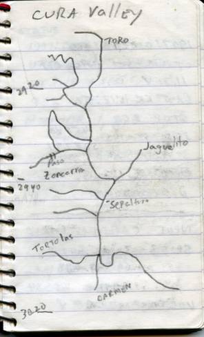
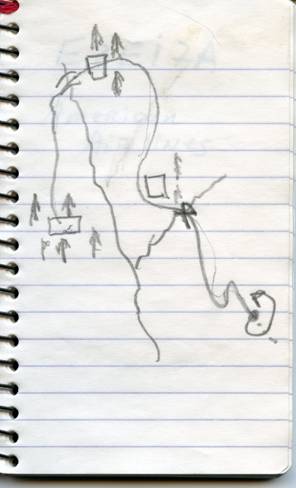
Here are two maps from
my log book. The one on the left is of
the Cura Valley, and I based it on a geodetic-quality
map that I examined while in San Juan. The second is of the area around the Condar Gendarmeria post and is
just a sketch map. The left-most square
is the post. The X marks the spot where we got the truck stuck in the mud at a
stream crossing. We worked several hours
trying to get it out, to no avail, but fortunately a group of men on horseback
happened by. They showed us some tricks
for dealing with mud, including covering it with loose, dry sand. Then they and we pushing together were able
to get the truck out.