-
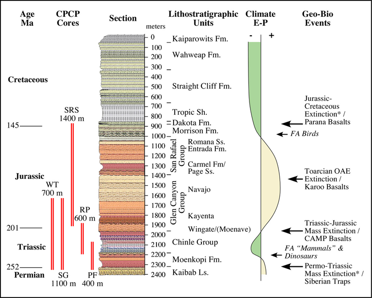
Early Triassic through Late Jurassic Formations
Should be Cored: A key, initially unanticipated, conclusion of the
workshop was the importance attached to spanning the full range of
climatic milieus represented by these rocks, and thus the need to core
the entire Triassic and Jurassic stratigraphic sequence including the
Morrison Formation. Collectively, the group defined a three-tiered
coring plan consisting of (1) three relatively thick (~1 km) synoptic
intervals that together would yield an overlapping stratigraphic
framework for the entire Jurassic and Triassic section, (2) two thin
(<500 m) cored sections that would tie to critical outcrop areas
or to expanded critical intervals, and (3) a number of shorter sections
to address more specific problems or provide more regional coverage to
the other five cores that are the nexus of the project.
-
Superposition is Paramount: All breakout groups
concluded that to evaluate the critical Early Mesozoic transitions it
is necessary to see all Early Mesozoic units in clear superposition. In
broad climatic terms, the five major stratigraphic units identified as
major coring targets reflect, from oldest to youngest: arid (Moenkopi);
humid to semiarid (Chinle); very arid (Glen Canyon and San Rafael); and
return to semiarid and humid (Morrison) (above). Climate transitions
have been explained in several ways, but most revolve around either a
translation of the North American plate from equatorial to
mid-latitudes through zonal climate belts (Dickinson, 2005; Kent and
Muttoni, 2003; Kent and Tauxe, 2005), or large scale changes in the
climate system involving changes in the non-zonal components of the
climate system, particularly the monsoon (Kutzbach and Gallimore, 1989;
Parrish, 1995; Rowe et al., 2007) or fluctuations in greenhouse gasses
(CO2) (e.g., McElwain et al., 1999;
Kürschner, 2001). That these hypotheses could be so
fundamentally different and remain untested rests on the fact that the
temporal evolution of major boundary conditions, most notably latitude,
has not been resolved to a useful level of precision (see below). The
clear test of these hypotheses involves the paleomagnetic determination
of latitude with necessary empirically derived corrections (e.g., Tauxe
and Kent, 2004; Tan et al. 2007) from all of the major units.
-
Internal Time Calibration Needed: Correlation
of the Plateau sequence is presently based on low-resolution and
untested non-marine biostratigraphic approaches and does not provide
clear biogeographic patterns or determination of the rates of biotic
change in these very fossiliferous sequences. NONE of the major
intervals of biotic change (e.g., Permo-Triassic; Triassic-Jurassic; or
Toarcian) are located with precision in this succession. A combination
of polarity stratigraphy along with geochronologic dates from ash
deposits and dispersed grains will allow correlation with Triassic and
Early Jurassic reference sections (e.g., Early Triassic composite
sections from Central Europe (Szurlies, 2007), the astronomically
calibrated polarity time scale from the Newark Supergroup basins (Kent
and Olsen, 1999, in press; Olsen and Kent, 1999), St.
Audrie’s Bay, UK (Hounslow et al., 2004; Kemp & Coe,
2007), the Germanic basin (Bachmann and Kozur, 2004), and fully marine
Tethyan sections (e.g., Muttoni et al., 2004; Channell et al., 2003;
Gallet et al., 2007), non-marine Jurassic to Early Cretaceous sequences
of China (e.g., Feursich et al., 2002; Yao et al., 2003; Xu, 2005) and,
possibly, the marine magnetic anomaly M-sequence (Sager et al., 1998)
in the Middle and Late Jurassic succession to be cored.
-
Minimize Hiatuses: Breakout groups recognized
the significant unconformities in the sections and the likelihood that
there are numerous smaller and cryptic hiatuses. Acquiring as much
stratigraphic scope as possible through the more continuous units and
testing any paleomagnetic reversal sequences across geography by
designing stratigraphic overlap between cores will help address these
concerns. The thickest sections, least likely to be affected by rampant
hiatuses, are not confined to a single small area in the Colorado
Plateau and adjacent areas because of lateral shifts in the
basin’s depocenters. Several cores will be necessary to get
the most favorable sections of each of the units. However, the thick
sections proposed for coring are far from comparable surface outcrops
and thus subsidiary sections more proximal to sources of the surface
data must be cored as well. The goal is to provide a long enough
section with unambiguous ties to the outcrop and sufficient
stratigraphic scope to correlate with the main, long cores.
-
Data Management Plan: A robust and effective
data management/geoinformatics system, accessible through a CPCP Data
Portal, will facilitate and support the science and provide the basis
for education and outreach efforts. This will include coupling the
drilling Information System (DIS) of the ICDP with SESAR
(www.geosamples.org), EarthChem (www.earthchem.org), CoreWall
(hwww.evl.uic.edu/cavern/corewall), and PaleoStrat
(www.paleostrat.org), a core-core hole-log integration system, and a
novel digital framework of regional geology.
-
Education and Outreach: Although not explicitly
detailed at the meeting, the group recognized that an education and
outreach program of the CPC will leverage the globally famous
attributes of the Colorado Plateau and environs.