N.B.,
FOR BEST RESULTS, PRINT AT 85%
3.2.2. Cyclicity, Climate, and Time scales
Paul E. Olsen, Lamont Doherty Earth Observatory, Palisades,
New York, 10964 USA
 |
The NSF funded Newark
Basin Coring Project (NBCP) (Fig. 3.2.2.1) resulted in the recovery
of about 6.8 km of continuous core from 7 coring sites making up a combined
4.7 km stratigraphic section spanning nearly all of the Late Triassic age
strata of the Newark rift basin (Olsen et al., 1996a). Additional core
from the Army Corps of Engineers, completed the Jurassic age part of the
Newark basin section (Olsen et al., 1996b). This core spans roughly 32
million years and provides the longest available continuous record of orbital
forcing of tropical climate (25 my), as well as allowing the construction
of an orbitally tuned geomagnetic polarity time scale for the Late Triassic
and earliest Jurassic, including the entire zone of basaltic extrusives
(Fig. 2.4). This core record and subsequent studies (see below) serves
as a test of concept for the Pangean Coring Transect. |
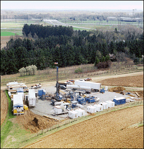
| Figure 3.2.2.1: The Princeton coring site of the
Newark Basin Coring Project. This is the SHADS set up of AMOCO Production
Company. Total depth at this site was 3697 ft (1087 m). |
|
| Orbital forcing in the Newark basin is revealed
as a hierarchy of lake level cycles that controlled by precipitation and
evaporation changes controlled by precession-related celestial mechanical
cycles (Fig. 3.2.2.2). The shortest period cycles, originally described
some 35 years ago (Van Houten, 1964), were controlled by climatic precession
(~20 ky) and these are modulated by ~100 ky, 404 ky, and 1.75 my cycles
of eccentricity (Olsen and Kent, 1996, 1999a). There is no obvious obliquity
(41 ky) signal, consistent with relatively local insolation forcing in
the tropics. A perhaps surprising aspect of the cyclicity is that the longest
period cycles of 1.75 my is significantly shorter than the corresponding
period is at present (2.35 my), a result that is plausibly due to the chaotic
behavior of the planets, specifically Mars (g4) and Earth (g3). The very
long Newark record in fact allows calculation of all of the major fundamental
frequency relating to eccentricity (Olsen and Kent, 1999a), assuming the
relative constancy of the 404 ky cycle over this time period (see Laskar,
this report).
A geomagnetic polarity reversal stratigraphy comprised
of 60 major zones has been recovered from the Newark core record (Kent
and Olsen, 1995) (Fig. 2.4). Stratigraphy of the polarity transitions has
been tested against the cyclostratigraphy in the overlap intervals between
stratigraphically successive cores and with outcrop and the data are completely
consistent regardless of lateral changes in rock color and accumulation
rate. The core paleomagnetic data also document a slow northward drift
of the Newark basin from at the equator to about 10° N latitude. |
 |
|
|
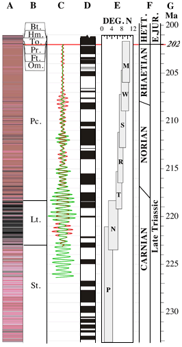
| Figure 2.4 (above): Newark basin time scale: A,
Rock Color; B, Formations (Bt., Boonton Fm.; Hm, Hook Mt. Basalt;
To., Towaco Fm.; Pr., Preakness Basalt; Ft., Feltville Fm.; Om.,
Orange Mountain Basalt; Pc., Passaic Fm.; Lt., Lockatong Fm.; St., Stockton,
Fm.);
C, Filtered lake depth proxy (red) and rock color (green)
showing the 404 ky lake-level cycles; D, Astronomically calibrated
geomagnetic polarity sequence; E, Paleolatitude of the coring sites
though time;
F, Relative Ages; G, Numerical age based on
astronomical calibration and radiometric ages from the basalts. Based on
Kent and Olsen (1999) and Olsen and Kent (1999). Click on image for a more
detaile veiw. |
|
Kent and Olsen (1999) and Olsen and Kent (1999a) used
the orbitally forced cyclicity as a basis for a high-resolution time-scale
for the polarity reversal stratigraphy. The principle basis for this time
scale is the 404 ky cycle caused by Venus and Jupiter (g2-g5), which on
first principles should be stable, at the appropriate scale, over hundreds
of millions of years (see Laskar, this report). The resultant astronomically
tuned geomagnetic polarity time scale (GPTS) covers the entire Late Triassic
and part of the Early Jurassic (Hettangian) and for the first time provides
a time scale of Neogene-levels-of-resolution for much of the Early Mesozoic.
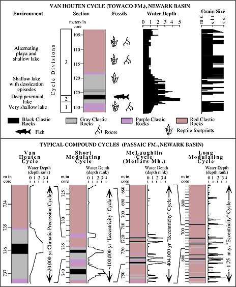
Figure 3.2.2.2 (above): Typical Van Houten cycle and modulating
(compound) cycles of the Newark basin cores (modified from Olsen and Kent,
1999a).
| The Newark basin astronomically tuned GPTS
has subsequently been used to provide a time scale and Milankovitch-level
correlation for portions of the lacustrine sections of several other basins
spanning 40° in paleolatitude (from north to south). These are the
Dan River rift basin of North Carolina and Virginia (Kent and Olsen, 1997),
the Taylorsville rift basin of Virginia (LeTourneau, 1999), the Fundy rift
basin of Nova Scotia, Canada (Kent and Olsen, 1999b), and the Jameson Land
basin of Greenland (Kent and Clemmensen, 1996). These basins span the coal-bearing
humid equatorial region through the evaporite-rich arid tropics into the
again coal-bearing humid temperate belt. Profound changes in the mode of
cyclicity and sedimentary facies accompany this latitudinal transect. Although
outcrop location and happenstance have limited the amount of section that
can be sampled in these basins, it is possible to examine several of these
basins along a latitudinal transect from about 7° to 39° N for
from about 209 to 211 Ma (Fig. 3.2.2.2). There is a very close correspondence
between the wettest intervals in these sections, but there is nonetheless
a change from 20 ky nearly pure precession forcing in the south to precession
plus obliquity forcing in the north, while the overall facies goes from
fairly wet, to arid, and back to fairly wet again. This Milankovitch-level
correlation necessary to test global climate models at the appropriate
levels precession (Sloan and Morrill, 1998) that allow discrimination of
completing hypotheses and reconciliation of seemingly disparate geological
and paleontological data. |
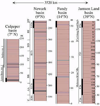 |
Figure 3.2.2.2 (above): Comparisons
of correlative sections of the
Culpeper, Newark, Fundy, and Jameson Land basins. Culpeper
section is from the Lenn Bros. no. 1 and Andrus no. 1
cores of the
Bull Run Formation (Balls Bluff Siltstone), Newark section is
from
the Somerset no. 1 core of the middle Passaic Formation (E16r-E18n
are magnetic polarity zones, and Z-FF are member names
from Kent
et al. 1995 and Olsen et al. 1996b), Fundy basin section is
based on
outcrop (Blomidon area, Nova Scotia) correlated by lithostratigraphy
to the GAV-3 core which is the source of the magnetostratigraphy
(Kent and Olsen, 2000b); Jameson Land basin section is
based on
Kent and Clemmensen (1996) (3M-7C are Clemmensen's designations
of ~100 ky cycles). See figure 2 for key to rock color. Figure
is
adapted from Olsen and Kent, 2000). |
|
Also extracted from the Newark basin core record, by use
of the astronomically tuned GPTS, is the accumulation rate scale for the
basin (Contreras, et al., 1997; Olsen and Kent, 1999a) as well as the duration
of the CAMP episode in the Newark basin. Accumulation rate, aspects of
the lacustrine facies, and the igneous events are strongly correlated,
suggesting a strong tectonic signal (see Schlische, this report). There
is a surprising degree of coherence between these same parameters over
at least 1000 km, as seen in the divergent basins listed above suggesting
regional-large scale tectonic controls. In as much, as this tectonic signal
reflects deep-seated underlying processes, the core record provides a quantitative
as well as qualitative basis for understanding fundamental physical Earth
processes.
REFERENCES