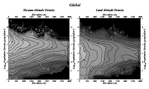
Global Distribution of Population and Land Area
The contour map on the left shows the joint distribution
of human population by altitude and human population density, or Human Altitude
Density (HAD)(left), as a contour map. Contour lines show log10(people).
For example, the contour curve on the left that is labeled 8 passes through
combinations of elevation and population density where about 100,000,000
people live. The bin size of both maps is 100m in elevation and Log10( density)/4.
The total population covered by all data points in this map is 5,665,532,570
The contour map on the right shows the joint distribution of land area
by altitude and human population density, or Land Altitude Density (LAD),
as a contour map. Contour lines shown log10(land area). For example, there
are about 1,000,000 sq.km of occupied land at each combination of elevation
and population density through which the contour curve on the left that
is labeled 6 passes. The total land area covered by all data points in this
map is 130,526,695 sq.km. In both distributions, the values falling outside
the bounds of the map (elevations > 4000 m and densities < 0.01 people/sq.km)
are accumulated in the peripheral bins.
We summarize the relationship between Earth's human population and its occupied land area by means of two estimated bivariate frequency distributions, one for absolute population (numbers of persons) and one for occupied land area, as functions of population density and elevation. The empirical bivariate density function of global human population as a function of population density and elevation (left), which we call the Human Altitude Density (HAD), describes how many people live at each possible combination of population density and elevation. The empirical bivariate density function of occupied land area as a function of population density and elevation (right), which we call the Land Altitude Density (LAD), describes how much occupied land Earth has at each combination of population density and elevation.
Global human population is heavily localized at low elevations
(left). Both the highest and lowest population densities in this dataset
occur at elevations below 100 m. Most humans live at densities between 1
and 10,000 people/km2 with a persistent modal density of 100-200 people/km2
at elevations higher than 300 m. At elevations lower than 300 m the modal
population density increases rapidly to over 500 people/km2 in the lowest
100 m above sea level. The distribution of population density is asymmetric
at all elevations with modal densities consistently displaced toward high
values. While there is a gradual increase in the minimum population density
(for a given elevation) with increasing elevation, the maximum population
density (for a given elevation) decreases very rapidly in the lowest 300
m and fluctuates widely at higher elevations. The prominent spur of high
population density (> 1000 people/km2 around 2300 m elevation) reflects
the heavily populated Mexican plateau. The population at elevations >
4000 m represents primarily Andean and Tibetan populations. The global distribution
of land (right) qualitatively resembles that of people. However, most land
area is occupied at a modal population density around 10 people/km2 at all
elevations, even though most people live at a modal density of ~100 people/km2
at almost all elevations. Because density is inversely proportional to area
for a given population, the center of mass of the HAD occurs at a higher
population density than that of the LAD; more people than land experience
high population density in crowded regions. Similarly, the center of mass
of the HAD occurs at a lower elevation than that of the LAD because the
higher elevations are, on the whole, thinly populated, and more land than
people experiences low population density.