Human population is not evenly distributed over available land area.
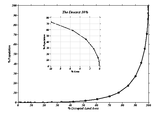
The curves above show minimum estimates of the cumulative distribution of human population over the earth's occupied land area (excluding Antarctica and Greenland). These curves demonstrate that population is not evenly distributed over the available land area. If this were the case, the curves would be straight lines (eg. 30% population would live on 30% of the land area, etc). The curvature gives an indication of the "concentration" of people in settlements (eg. 50% of the world's population lives on less than 4% of the available land area).
The Motivation for the Study
The distribution of the human population by altitude affects human exposures to varied geophysical and biological hazards (Baker 1969, De Jong 1970). The coastal, low-altitude location of many of the world's largest cities suggests that much of the population lives at low elevations near coastlines. The coastal cities of Tokyo, New York, Bombay, Shanghai, Los Angeles, Calcutta, Buenos Aires, Seoul, Lagos, Osaka, and Rio de Janeiro comprise11 of the world's 15 cities with more than 10 million people [United Nations 1997]. The human population living on coastal plains and in low-lying drainage basins and could be directly affected by sea-level rise, increased storm surge activity, climatic changes in precipitation and lowland flooding.
In addition to the more obvious coastal hazards, several health related hazards are also influenced by altitude. Specifically, physiological (Yancey et al. 1992, Yancey and Richards 1994, Cogswell and Yip 1995, Mangione 1995, Alderman et al. 1995, Hankins et al. 1996, Jones et al. 1992, Smith et al. 1994, Dirren et al. 1994, White et al. 1994, Imai et al. 1995, Ghio et al. 1996) and epidemological (e.g. malaria, filaraisis (Merler et al. 1996), visceral leishmaniasis (Ali and Ashford 1994, Mutero et al. 1992), toxoplasmosis (Yamaoka and Konishi 1993)) threats to human health depend on altitude. A number of agricultural factors are also dependent on elevation Pozio et al. 1996, French et al. 1994). The balance of benefits and hazards to human populations located at different altitudes depends on diverse physical, biological, economic and historical factors. An understanding of the distribution of human population with respect to altitude is fundamental to understanding this balance.
To evaluate the potential impact on the human population of hazards related to altitude, it is necessary to know the number and location of people who could be directly affected. Local and regional studies of coastal hazards [e.g. Brammer, 1993, Broadus 1993, Hekstra 1990; Milliman et al 1989, Nichols & Leatherman, 1995, Perdomo and Vellinga 1992, Voigt 1992, Warrick, 1993, Barrow and Wigley 1993, Clarke and Rhind 1992] provide detailed analyses in many high-risk areas but do not provide a systematic global view of the spatial distribution of human population in relation to continental hypsography. Direct measurement of immediate hazard requires more variables than elevation and population but analysis of these two parameters can provide an estimate of the number and location of people potentially at risk. This type of global analysis enhances the value of local studies by developing a global picture to which they can be compared.
Newly available global databases of human population and digital elevation
models of the continents can be used to establish a global framework for
these local studies. We integrate these databases in a moderate-resolution
digital map that gives the estimated human population in 1994 and the elevation
above sea level of 2,003,971 quadrangles with population density greater
than one person per 147 km2 (0.007 person perkm2). This global data fusion
has a number of applications; we focus here on the most fundamental - the
joint distribution of population and elevation.