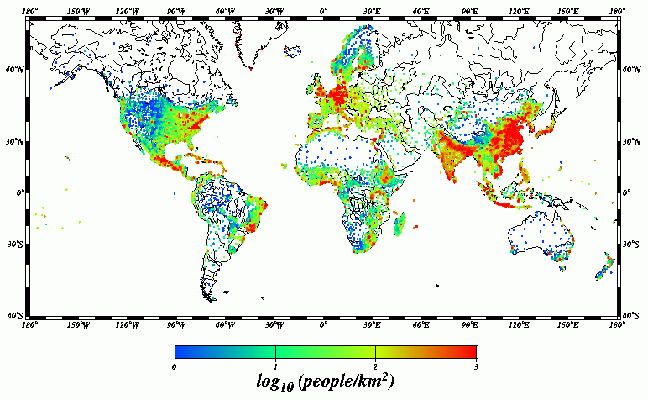
The map above shows the global variation in population density on a logarithmic scale. Each color change indicates a ten-fold increase in population density. Each individual point shows the location of the administrative unit for which the census data were collected. This dataset contains 19,032 population estimates with a median spatial resolution of 40 km.
The human population distribution is described by datasets produced in
1995 by the National Center for Geographic Information and Analysis (NCGIA University of California, Santa
Barbara). Tobler et al. [4] collected census information on 217 countries
partitioned into a total of 19,032 secondary administrative subdivisions
(corresponding to counties in the United States). The census years ranged
from 1979 to 1994. Tobler et al. estimated the 1994 populations of these
19,032 polygons by projecting from the census years to 1994. The total 1994
population estimated in this way is 5,617,519,139 people.
(The uncertainty of this estimate probably exceeds 2%, based on censuses
in developed countries. For comparison, exponential interpolation between
world population estimates for 1990 and 1996 (United Nations 1996; U. S.
Bureau of the Census, 1996) gives 5.60 x 10⁹ people.) The polygons occupied
by humans totaled 130,526,695 km2, 25.9% of the world's surface area and
99.5% of ice-free land, approximately 1.33 x 10⁸ km2 (Harte 1988, p. 236).
The average population density of occupied land described by this dataset
is 43 people/km2. These data have been used as the basis for a mass-conserving
spatial redistribution, to produce gridded population estimates with a horizontal
resolution of 5' (Tobler et al, 1995). The total number of people in the
gridded model is 5,665,532,570 and is slightly larger than the total from
the original 19,032 points. This 0.85% discrepancy in estimated total population
is believed to result from the gridding procedure (W. Tobler, U. Deichmann,
personal communications) but is significantly smaller than the expected
error in the original population estimates.