Population and Elevation in Southeast Asia
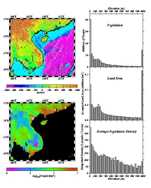
Southeast Asia provides an interesting example of some of the basic physical factors influencing population distribution. The two maps above show the combined continental and submarine topography of southeast Asia (top) and the distribution of population (bottom). It is apparent from the elevation map that the present position of the coastline (heavy black line) is quite different from the steep submarine slope that marks the actual edge of the continent where the South China Sea deepens from 200 to 1000 meters. This map emphasizes the point that coastlines are ephemeral features and move significantly when sea level changes. The rugged topography of the Wuliang Shan mountains in the northwest extends southward into Vietnam creating a very narrow coastal plain in contrast to the much wider coastal plains to the north and east of the Gulf of Thailand. These major physiographic features in the elevation map are reflected somewhat in the adjacent population density map. Most, but not all, of the rugged mountainous regions are very sparsely populated. The densest concentrations of people are located along the coast and on low lying river deltas. A significant change in regional population density can also be seen across the border between Vietnam and China, north of Hainan Island.
Some of the information contained in these maps can be combined and condensed into elevation histograms shown on the right. The distribution of population with elevation is quite dramatic, showing that 80 million people in Southeast Asia live within 25 meters of sea level. It is difficult to predict the impact that a gradual 1 meter increase in sea level would have on this region but it is clear that a 6 meter storm surge could be devastating in a number of areas. Several of these areas are currently experiencing rapid population growth. The distribution of occupied land area with elevation shows that the population distribution is accommodated somewhat by the hypsography of the continent; there is more land area available near sea level than at any other elevation. When the population distribution is adjusted for the available land area we can determine how average population density varies with elevation. Overall, sea level is still the "elevation of choice" with far more people per available area than any other elevation range. Population densities in the large cities are actually much higher than average population densities.