U.S./Chinese Ship-of-Opportunity Sampling and Research Program

Repeated XBT/XCTD Lines in the Southern Ocean

Program Description | Objectives | Sponsors | Principal Investigators | Implementation | Results | In News | Reference

R/V Xuelong services Chinese Antarctic Stations annually and provides the ship-of-opportunity for the program.


Program Description

Supported by National Science Foundation of United States and Chinese Arctic and Antarctic Administration, scientists from Lamont-Doherty Earth Observatory of Columbia University and Polar Research Institute of China have collaboratively conducted two oceanographic sampling programs in the Southern Ocean since 1997. The overarching motivation of these programs was to obtain consistent long-term time series measurements in regions of the Southern Ocean notably lacking in data and to address scientific issues regarding the polar ocean's role in the global climate. These earlier programs have assessed the feasibility and practicality of obtaining annually repeated upper ocean temperature and salinity profiles from the Chinese research vessel, R/V Xuelong, during its annual Antarctic re-supply runs, and established the foundation of a reliable sampling program that could be readily extended to a low-maintenance long-term sampling effort.

The earlier programs established two sampling lines: one is a zonal line near 61S in the Weddell Sea and other is from Fremantle, Australia to Prydz Bay, Antarctica on a diagonal crossing of the Southeast Indian Ocean. Scientists from both institutes have conducted four years of sampling along these two lines since 1998. The data quality control procedure has been established. Interannual variability of upper ocean thermal structure in the Southeast Indian Ocean are analyzed based on collected data (Yuan et al., 2003). These earlier programs have demonstrated that this ship-of-opportunity sampling is a feasible and cost-effective way to monitor the grossly under sampled Southern Ocean. Collected data start to contribute toward understanding the physical environment of this remote but climatically important area. Based on the results, National Science Foundation of the United States recently provides a new funding for a five-year (2003-2007) extension of the collaborative program.

Updated XBTs (circles) and XCTDs (stars) sampling locations in the Southeast Indian Ocean and Weddell Sea since 1998.


Objectives

The program is motivated by: (1) the need to obtain consistent long-term upper ocean time series measurements in Southern Ocean regions notably lacking in data and necessary to improve our understanding of the role of the Southern Ocean in global climate, and (2) the need to address a number of specific scientific issues involving the role of the ocean in the air-sea-ice system with the Weddell gyre and South Indian Ocean sectors in regional and extra-polar climate variability. The immediate scientific ob jectives of this 5-year program are as follows.

    1. Extend the sparse and irregular time series of upper ocean variability, previously obtained in the Weddell gyre to further assess the nature of the Weddell-extrapolar climate teleconnection, particularly to examine the upper ocean's response to ENSO events (dominant Weddell signal).
    2. Improve our understanding of the role of the ocean in the air-sea-ice interactions in the central/eastern Indian Ocean sector of the Antarctic by investigating the relationships among surface wind, sea ice distribution and upper ocean properties (e.g., heat content, bulk stability, geostrophic flow, polar front position, etc.). Attempt to isolate the nature of the air-sea-ice system that is unique to the Indian Ocean sector relative to that found elsewhere around the Antarctic, and that may influence subpolar cyclogenesis and regional heterogeneity in polar-extrapolar teleconnections.
    3. Extend already initiated sustained upper ocean observational series for climate studies in the Southern Ocean, and globally.

Sponsors


	National Science Foundation
	United States of America

	Chinese Arctic and Antarctic Administration
	State Ocean Administration
	People's Republic of China

Principal Investigators


	Xiaojun Yuan
	Doherty Research Scientist
	Lamont-Doherty Earth Observatory of Columbia University
	The United States

	Zhaoqian Dong
	Honorary Director
	Polar Research Institute Of China
	People's Republic of China

	Douglas G. Martinson
	Doherty Senior Research Scientist
	Lamont-Doherty Earth Observatory of Columbia University
	The United States

Implementation


The sampling will continuously target the two regions in the Weddell Sea and Southeast Indian Ocean. Planned sampling locations are shown in the following figure. For Indian Ocean transect, XBT sampling density will be about 100km. Sixteen XCTD stations will be sampled along the cruise track and two CTD stations will be taken at each end of the section. For Weddell Sea transect, XBT will be sampled at the resolution of 55km and XCTD will be sampled at the resolution of 130km. Two CTD stations are also planned at each end of the section. All XBT and XCTD data will be quality-controlled at Lamont-Doherty Earth Observatory and processed data will be submitted to the National Oceanography Data Center within 6 months after they are collected.


Planned sampling locations for XBTs (red crosses), XCTDs (black triangles) and CTDs (blue circles).


A XBT probe is launched through a hand-hold launcher from the fantail of R/V Xuelong.


The temperature and pressure measurements collected by the XBT probe are transmitted to a on-board computer instantly.


Results

XBT/XCTD observations from four cruises across the Southern Ocean from Fremantle, Australia to Prydz Bay, Antarctica were analyzed to examine the upper ocean thermohaline structure in the southeast Indian Ocean and its temporal variability. The transects were occupied in March 1998, November 1998, March 2000, and March 2002 (Figure 1). A strong temporal variability is found in the upper ocean thermal structure in the polar gyre southeast of the Kerguelen Plateau. The depths of the mixed layer and Tmin layer deepen with time. The mixed layer temperature decreases while the Tmin temperature increases in the same time. In addition, the ice-free period prior to XBT/XCTD sampling and surface wind stirring measured by friction velocity cube during the ice-free period increase from 1998 to 2002. The analysis suggests that the longer period that ocean is exposed to the atmosphere and the stronger wind stirring will cause enhanced turbulent mixing, which result a deeper mixed layer depth and entrainment of more cold water from the Tmin layer to the mixed layer. These surface forcing also enhance internal diffusive processes that mix the Tmin water with the warmer waters above and below the Tmin layer. The surface forcing apparently dominate in determining the upper ocean thermal structure in this polar region. (Yuan et al., 2004)

XBT (circles) and XCTD (stars) sampling locations in the Southeast Indian Ocean between 1998 and 2002. The square indicates the study area south of the polar front.

Both mixed layer and Tmin layer depth in March (early austral spring) decrease with time. In the same time, mixed layer temperature decreases while Tmin layer temperature increases. As a consequece, upper ocean heat content meansured by Enthalpy decrease with time during the study period.


The variability of upper ocean thermal structure linearly depends on two surface factors: the length of period when the ocean exposes to the amtosphere (ice-free days) and surface kinetic energy flux ( proportion to friction velocity cubed), indicating that these two factors plays important roles in determining upper ocean thermal structure.


The relationships between the upper ocean thermal structure and the surface factors are examined in historical data from 1980 to 1996. Our observations are marked in bold symbols. The surface kinetic energy flux remains in good relationships with mixed layer depth, mixed layer and Tmin layer temperature.

This material is based upon work suppoted by the National Science Fundation under grant No. 0230284. Any opinions, findings, and conclusions expressed in this material are those of the authors and not necessarily relect the views of the NSF.

Publications


McKee, D. C; X. Yuan; A. L. Gordon; B. A. Huber; Z. Dong. Climate Impact on Interannual 
	Variability of Weddell Sea Bottom Water. J. Geophys. Res. - Oceans. VOL. 116, 
	C05020, doi:10.1029/2010JC006484, 2011.

Patoux, J., X. Yuan and C. Li, Satellite-based midlatitude cyclone statistics over the 
	Southern Ocean: 1. Scatterometer-derived pressure fields and storm tracking, 
	J. Geophys. Res., 114, D04105, doi:10.1029/2008JD010873, 2009.

Yuan, X., J. Patoux and C. Li, Satellite-based midlatitude cyclone statistics over the 
	Southern Ocean: 2. Tracks and surface fluxes. J. Geophys. Res., vol. 114, 
	D04106, doi:10.1029/2008JD010874, 2009.

Yuan, X., and C. Li, Climate modes in southern high latitudes and their impacts on 
	Antarctic sea ice, J. Geophys. Res., 113, C06S91, doi:10.1029/2006JC004067, 2008. 

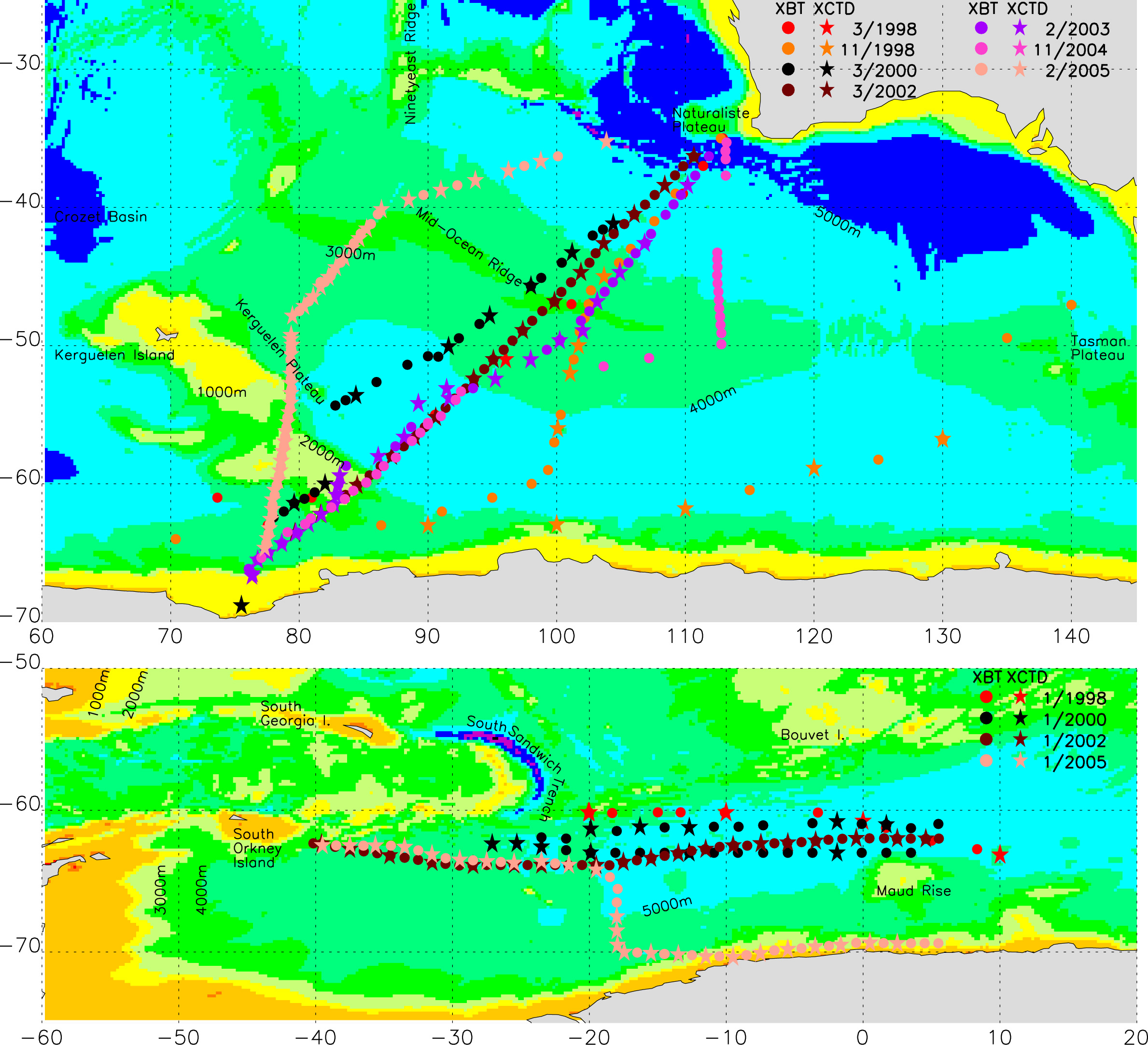
He, Z., Z. Dong, and X. Yuan, Fronts and strong currents of the upper southeast 
	  Indian Ocean. Acta Oceanologica Sinca, 25(2), 1-24, 2006.

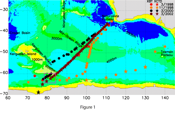
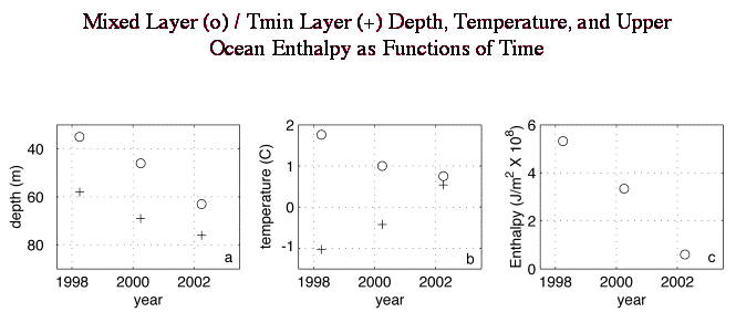
Yuan, X., D. G. Martinson, and Z. Dong, Upper Ocean Thermohaline Structure and
          its Temporal Variability in the Southeast Indian Ocean. 
          Deep-Sea Research, Vol. 51, No. 2, 333-347, 2004.
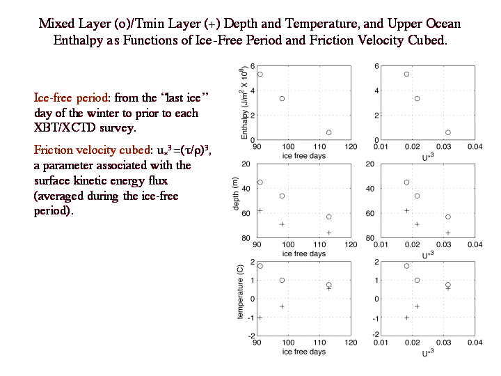
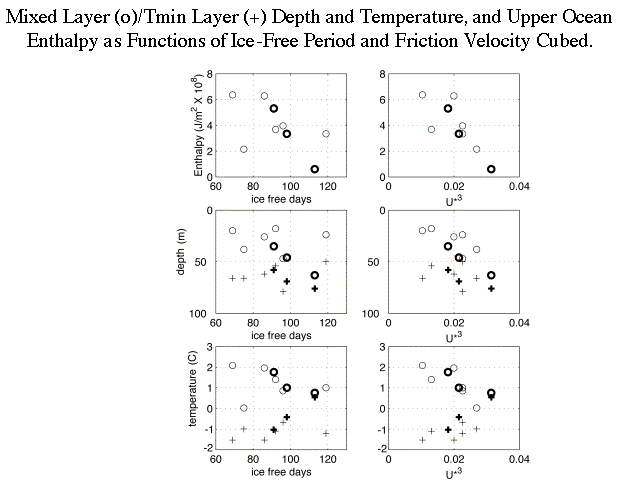

This page is maintained by Xiaojun Yuan (xyuan@ldeo.columbia.edu). The last update was on 4/3/2012