SCIENTIFIC MOTIVATION
 The central goal of the project is to understand the
structure and evolution of the North American continent.
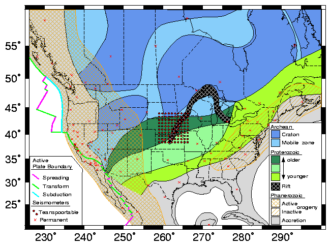
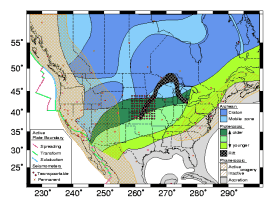
North America exhibits nearly every
type of geologic setting. As shown in
Figure 1,
it includes one of the
Earth's great orogenic plateaus and one of the great continental cratons,
active plate margins bounded by major strike-slip, subduction, and rift fault
systems, an active hot spot, modern passive margins, and the remnants of a
Paleozoic mountain belt of Himalayan proportions.
Its seismic structure has been explored on many scales using
data from North American stations of the Global Seismographic Network and
affiliated stations, a number of regional arrays, a growing number of
PASSCAL experiments, and numerous reflection and refraction profiles.
However, many important questions remain, in particular concerning
the relationships between the smaller geological-province
and crustal scale structures and the larger continental and lithospheric
scale structures.
Viewed slightly differently, a principal objective of the USArray project
is to tie together the seemingly disparate tectonic
provinces into a coherent model of the origin
and evolution of continental lithosphere.
The central goal of the project is to understand the
structure and evolution of the North American continent.
North America exhibits nearly every
type of geologic setting. As shown in
Figure 1,
it includes one of the
Earth's great orogenic plateaus and one of the great continental cratons,
active plate margins bounded by major strike-slip, subduction, and rift fault
systems, an active hot spot, modern passive margins, and the remnants of a
Paleozoic mountain belt of Himalayan proportions.
Its seismic structure has been explored on many scales using
data from North American stations of the Global Seismographic Network and
affiliated stations, a number of regional arrays, a growing number of
PASSCAL experiments, and numerous reflection and refraction profiles.
However, many important questions remain, in particular concerning
the relationships between the smaller geological-province
and crustal scale structures and the larger continental and lithospheric
scale structures.
Viewed slightly differently, a principal objective of the USArray project
is to tie together the seemingly disparate tectonic
provinces into a coherent model of the origin
and evolution of continental lithosphere.
THE TRANSPORTABLE ARRAY
 The experiment envisioned for the mobile portion of USArray is
a 10-year-long roving deployment across the contiguous US with
potential land extensions into Canada and Mexico, as well as
seafloor extension onto the continental shelf.
The target area of ten million square kilometers could be
uniformly covered by, for example, 20 deployments of 100
seismometers, each of six months' duration and with the geometry
depicted in Figure 1.
The result of the experiment would be a uniform, internally consistent
data set with well understood spatial sampling and aliasing properties,
which would be used to image the entire continent in the same detail
and resolution. Many
natural opportunities would exist to encourage and coordinate
add-on PASSCAL experiments with the deployment of USArray.
The experiment envisioned for the mobile portion of USArray is
a 10-year-long roving deployment across the contiguous US with
potential land extensions into Canada and Mexico, as well as
seafloor extension onto the continental shelf.
The target area of ten million square kilometers could be
uniformly covered by, for example, 20 deployments of 100
seismometers, each of six months' duration and with the geometry
depicted in Figure 1.
The result of the experiment would be a uniform, internally consistent
data set with well understood spatial sampling and aliasing properties,
which would be used to image the entire continent in the same detail
and resolution. Many
natural opportunities would exist to encourage and coordinate
add-on PASSCAL experiments with the deployment of USArray.
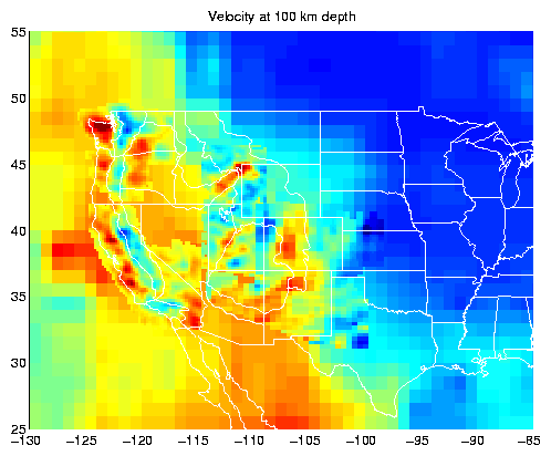
 Results from recent regional PASSCAL experiments provide examples of the
type of seismological mapping of the continent that could be achieved with
the new array.
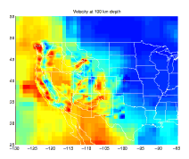
Figure 2
shows results from P and S wave tomography of
the western US using teleseismic arrival time data. A clear separation is
seen between the fast cratonic core and the heterogeneous but largely slow
orogenic belt. In the orogenic belt, low velocities correlate with areas of
young volcanism, and near the plate margin, high velocities correspond with
tectonic domains,
indicating a surprisingly complex upper mantle structural geology.
Isostatic calculations show that in the high western US
interior thermal effects alone cannot explain the high velocities and low
densities of the mantle, and that some compositional modification of the
mantle, such as basalt depletion, may have occurred as well.
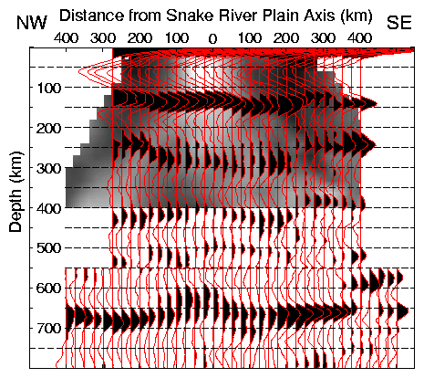
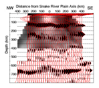
Figure 3
shows results from receiver function studies across the Snake River Plain,
revealing both significant velocity heterogeneity and topography
on the 410 and 660 km discontinuities.
These variations indicate lateral variations in temperature or composition
that occur in the upper mantle beneath an active portion of North America.
Results from recent regional PASSCAL experiments provide examples of the
type of seismological mapping of the continent that could be achieved with
the new array.
Figure 2
shows results from P and S wave tomography of
the western US using teleseismic arrival time data. A clear separation is
seen between the fast cratonic core and the heterogeneous but largely slow
orogenic belt. In the orogenic belt, low velocities correlate with areas of
young volcanism, and near the plate margin, high velocities correspond with
tectonic domains,
indicating a surprisingly complex upper mantle structural geology.
Isostatic calculations show that in the high western US
interior thermal effects alone cannot explain the high velocities and low
densities of the mantle, and that some compositional modification of the
mantle, such as basalt depletion, may have occurred as well.
Figure 3
shows results from receiver function studies across the Snake River Plain,
revealing both significant velocity heterogeneity and topography
on the 410 and 660 km discontinuities.
These variations indicate lateral variations in temperature or composition
that occur in the upper mantle beneath an active portion of North America.
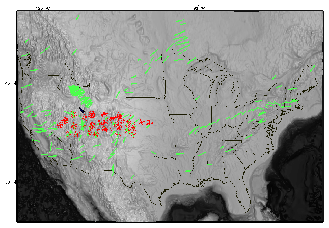
 In addition to a mapping of the isotropic velocity structure of the deep
portion of the continent, constraining its temperature and composition,
mapping of the anisotropic properties would provide us with a history of the
deformation of the continental mantle.
Figure 4
shows a compilation of S-wave
splitting results across North America. Anisotropy beneath the tectonically
inactive portion of North America, and beneath the Yellowstone swell, is
aligned in a direction that is generally consistent with shearing of the
continental lithosphere (or, for Yellowstone, the asthenosphere) in the
direction of absolute plate motion. Results from much of the elevated western
US, however, are complex and must represent small-scale,
poorly understood deformation processes
beneath this currently active area. The transportable array would allow us to
map anisotropy uniformly across the continent.
In addition to a mapping of the isotropic velocity structure of the deep
portion of the continent, constraining its temperature and composition,
mapping of the anisotropic properties would provide us with a history of the
deformation of the continental mantle.
Figure 4
shows a compilation of S-wave
splitting results across North America. Anisotropy beneath the tectonically
inactive portion of North America, and beneath the Yellowstone swell, is
aligned in a direction that is generally consistent with shearing of the
continental lithosphere (or, for Yellowstone, the asthenosphere) in the
direction of absolute plate motion. Results from much of the elevated western
US, however, are complex and must represent small-scale,
poorly understood deformation processes
beneath this currently active area. The transportable array would allow us to
map anisotropy uniformly across the continent.
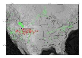
A denser network of high-quality stations will be valuable as
a set of fixed
reference points for the portable USArray deployments:
current efforts to combine tomographic images from a
variety of portable experiments have been hampered
by the lack of a common baseline between studies. In addition,
some tomography experiments benefit from the accumulation of
many observations at a single site, since this allows for a
better separation of local and distant wave propagation effects.
These considerations suggest that an initial goal for the
permanent component of USArray should be uniform coverage.
To achieve a density of one high-quality
station every 350 km within the conterminous US, approximately
30 stations would have to be added to the existing inventory of
sites (see Figure 1); several existing stations would need
to be upgraded.
 An expanded network of stations, contributing data in near real time
to the USGS NSN, would improve the detection, location, and source
characterization capabilities of the NEIS for earthquakes and other
seismic events in the US and surrounding areas. With this expanded
network, moment tensor estimation of earthquake parameters from
regional waveforms could include earthquakes to smaller magnitudes
(approximately magnitude 3.5) anywhere in the continental US.
Moment tensors of smaller earthquakes would provide information
on current stresses and modes of
deformation within the continent. For example,
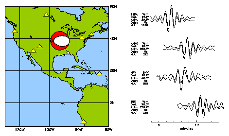
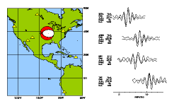
Figure 5
shows
the normal faulting mechanism of the 1997 M=4.9 Alabama earthquake, which
was large enough to be studied using data from IRIS GSN stations at
far-regional distances. A dense national network would
allow this type of characterization for much smaller earthquakes.
An expanded network of stations, contributing data in near real time
to the USGS NSN, would improve the detection, location, and source
characterization capabilities of the NEIS for earthquakes and other
seismic events in the US and surrounding areas. With this expanded
network, moment tensor estimation of earthquake parameters from
regional waveforms could include earthquakes to smaller magnitudes
(approximately magnitude 3.5) anywhere in the continental US.
Moment tensors of smaller earthquakes would provide information
on current stresses and modes of
deformation within the continent. For example,
Figure 5
shows
the normal faulting mechanism of the 1997 M=4.9 Alabama earthquake, which
was large enough to be studied using data from IRIS GSN stations at
far-regional distances. A dense national network would
allow this type of characterization for much smaller earthquakes.
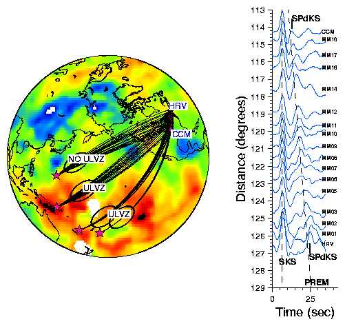
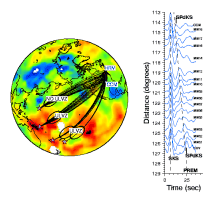 The permanent component of USArray could also be used to probe
deep Earth structure on a global scale.
Figure 6,
for example, shows a record section across the MOMA array; the
emergence of the diffracted phase SPdKS is indicative of an ultra-low
velocity region above the core-mantle boundary in the central Pacific.
The permanent component of USArray could also be used to probe
deep Earth structure on a global scale.
Figure 6,
for example, shows a record section across the MOMA array; the
emergence of the diffracted phase SPdKS is indicative of an ultra-low
velocity region above the core-mantle boundary in the central Pacific.
CONCLUSION
By itself, USArray is a facility and an experiment in seismology
and geophysics. Its success would require the active participation
of the broader IRIS community. It would provide a natural
venue for pursuing IRIS education and outreach goals in seismology.
In concept, USArray is also envisioned to be a key element
of a coordinated program of broad, interdisciplinary Earth science
study of the North American continent. Each of the USArray
temporary deployments, moving across the rich variety of geologic
provinces of North America, could be the observational core of an
integrated field laboratory involving the full spectrum of geoscience investigations, and could also provide a prominent center for an exciting
public education program.
ACKNOWLEDGEMENT
This article summarizes presentations by the authors at the
1997 IRIS instrumentation workshop in Santa Fe and the 1998
IRIS annual workshop in Santa Cruz. Our attempt at formulating the
USArray concept is based on earlier ideas and proposals of various
groups and individuals. In particular, we acknowledge the contributions
and assistance of Ray Buland, Ken Dueker, Karen Fischer, Bob Hutt,
Art Lerner-Lam, Anne Meltzer, Tom Owens, Jeff Park, Peter Shearer,
Anne Sheehan, Rob van der Hilst,
Bob Woodward, Michael Wysession,
and George Zandt.