
Research Scientist
Borehole Research Group
Lamont-Doherty Earth Observatory
of Columbia University
Rte 9W
Palisades, NY 10964
Tel: (845) 365 8671
guerin@ldeo.columbia.edu
|
|
Research Scientist Borehole Research Group
Rte 9W
|
Education
- Ph.D. from Columbia University (2000) - Dissertation title: Acoustic and Thermal Characterization of Oil Migration, Gas Hydrates formation and Silica Diagenesis (Download PDF [60Mb])
- Graduate from Ecole Superieure d'Ingenieurs de Marseille (ESIM, Now Ecole Centrale de Marseille, France) (1991) - Major in Offshore Engineering
- DEA (~MSc) in Ocean Sciences from the University of Marseille-Aix II (1991)
Interests
As part of my PhD, I worked on the characterization of the geophysical signature of various processes in marine sediments:
In situ acoustic properties of calcareous sediments across an OpalA/OpalCT diagenetic front (Download PDF [2Mb])
Characterization of the in situ elastic properties of Gas Hydrate-bearing marine sediments (Download PDF [8Mb])
Reservoir Simulation to validate 4-D seismics (Download PDF [30Mb])
Numerical modeling of the thermal effect of fluid migrations in an active fault zone (Download PDF [11Mb])
The best part of my work is obviously sailing and collecting data at sea...
I sailed as Logging Scientist onboard the R/V Joides RESOLUTION on the following cruises of the Ocean Drilling Program (ODP) and the Integrated Ocean Drilling Program (IODP) :
Leg 148 (1993): Return to Hole 504B, Costa Rica rift;
Leg 150 (1993): New Jersey Continental Slope and Rise;
Leg 158 (1994): TAG Hydrothermal Mound, mid-Atlantic ridge;
Leg 169 (1996): Sedimented Ridges II: Middle Valley and Escanaba trough;
Leg 185 (1999): Izu-Mariana Margin;
Leg 201 (2002): Deep Biosphere, Eastern Equatorial Pacific and Peru Margin;
Leg 204 (2002): Hydrate Ridge, offshore Oregon;
IODP Phase 1 mobilization (summer 2004): Gamagori to Astoria;
IODP Expedition 311 (fall 2005): Cascadia Margin Gas Hydrates;
IODP Phase 2 mobilization and sea trials (winter 2009): Singapore to Hawaii;
IODP Expedition 323 (summer 2009): Bering Sea Paleoceanography;
IODP Expedition 317 (fall 2009): Canterbury Basin Sea Level;
IODP Expedition 335 (spring 2011): Superfast Spreading Rate Crust 4;
IODP Expedition 340T (winter 2012): Atlantis Massif Core Complex;
Expedition 344S (summer 2012): Baffin Bay Scientific Coring Project;
IODP Expedition 345 (winter 2013): Hess Deep plutonic crust;
IODP expedition 350 (spring 2014): Izu-Bonin-Mariana Rear Arc.
In the latest incarnation of IODP, now the 'discovery program' where logging has been reduced, I sailed on a couple of expeditions, with less responsibilities but the same pleasure at sea:
IODP expedition 362 (summer 2016): Sumatra Seismogenic Zone.
IODP expedition 393 (summer 2022): The South Atlantic Transect (2).
And once onboard the Japanese vessel D/V Chikyu, to try to get samples and measurements deep into the Nankai Trench seismogenic zone:
IODP expedition 358 (winter 2019): NanTroSEIZE Plate Boundary Deep Riser 4.
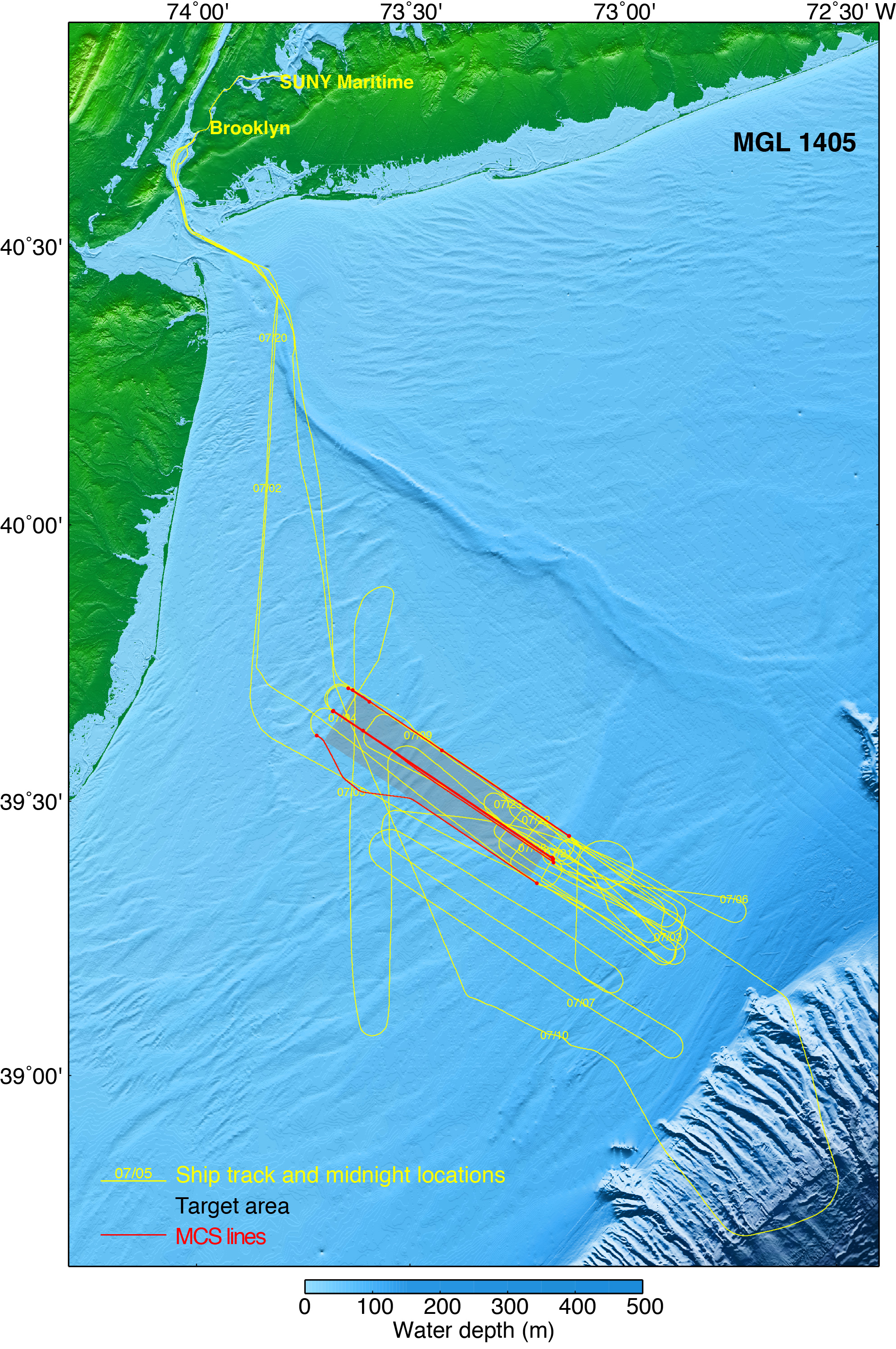
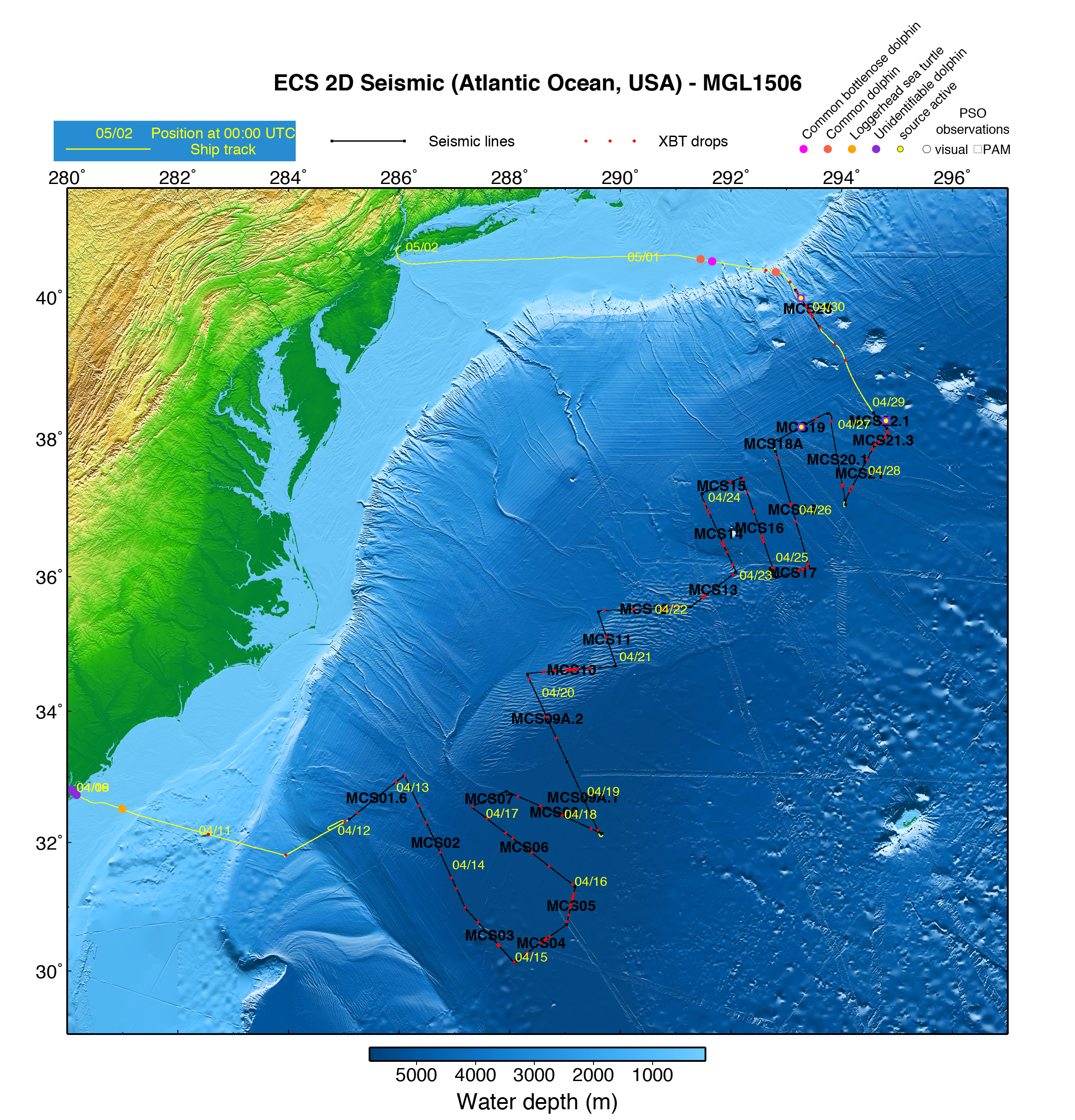
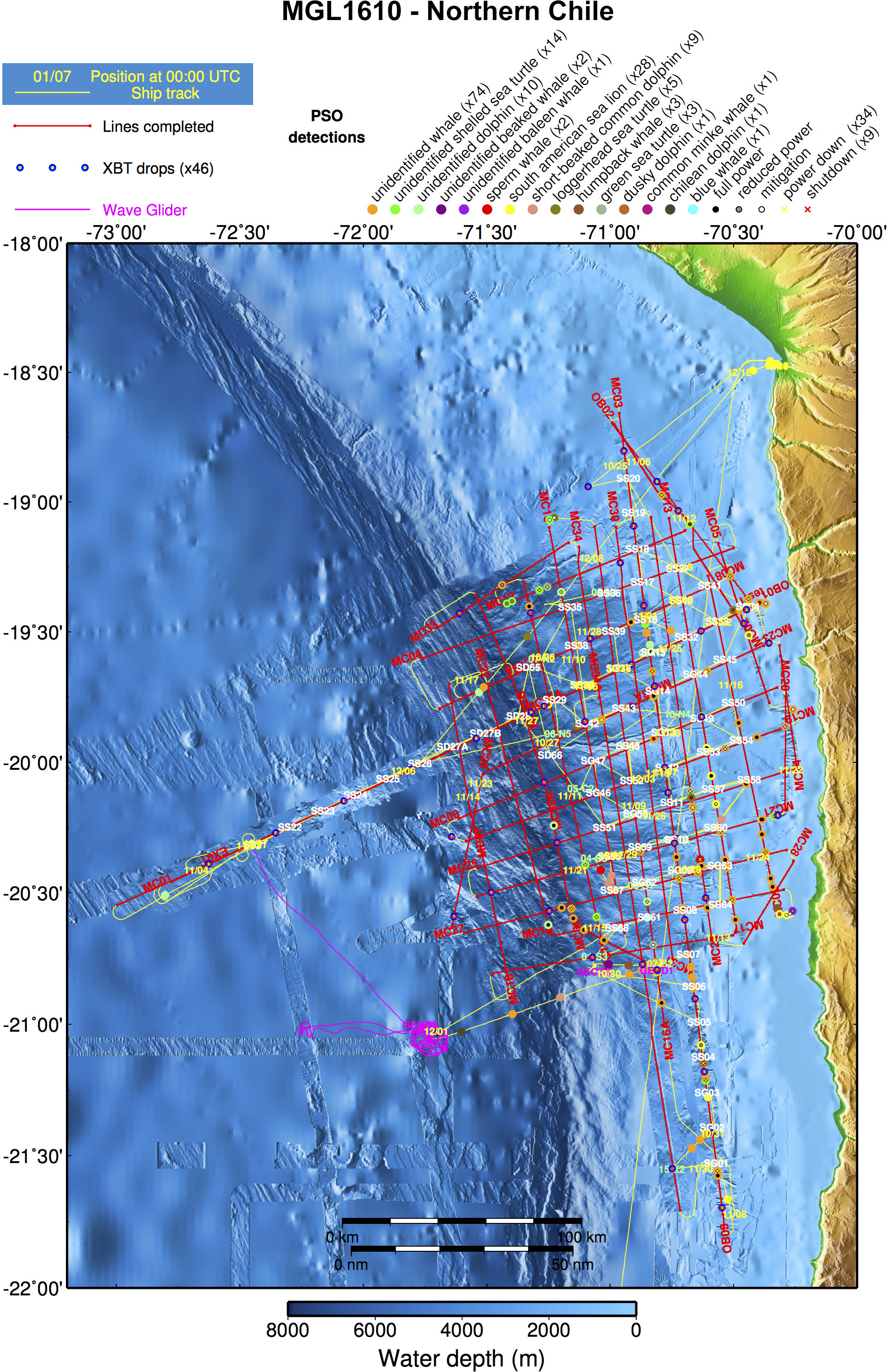
In recent years, I have mostly sailed on the R/V Marcus G. Langseth, providing support for acquisition of seismic surveys. A smaller vessel, with a much smaller crew and a more hands-on approach to operations. As I was monitoring the acquisition of terabytes of data, I started thinking of ways to illustrate the diversity of the data collected duting each cruise. Somehow I became the unofficial map maker (including this one) and, one cruise at a time, increased the amount of data that could be displayed on a map:
MGL1405 (summer 2014): 3D Imaging of New Jersey continental margin;
MGL1408 (fall 2014): Mid-Atlantic US margin seismic experiment;
MGL1506 (april 2015): Atlantic US Extended Continental Shelf;
MGL1510 (june 2015): 3D Imaging of New Jersey continental margin;
MGL1512 (august 2015): Multibeam survey of US Extended Continental Shelf;
MGL1521 (fall 2015): Imaging the deep Santorini volcanic system;
MGL1610 (fall 2016): Imaging of the Pisagua/Iquique earthquake rupture;
MGL1701 (winter 2017): Crustal Examination from Valdivia to Illapel to Characterize Huge Earthquake (CEVICHE);
MGL1708 (fall 2017): Seismogenesis at Hikurangi Integrated Research Experiment (SHIRE), off New Zealand’s North Island;
MGL1801 (winter 2018): 3D survey off New Zealand’s North Island;
MGL1806 (fall 2018): Hawaii-Emperor Seamounts Phase 1;
MGL1902 (spring 2019): Hawaii-Emperor Seamounts Phase 2;
MGL1905 (summer 2019): 3D and 2D imaging of the Axial underwater volcano;
MGL2003 (summer 2020): Andreanof Experiment, Aleutian Arc;
MGL2104 (spring 2021): Cascadia Subduction Zone;
MGL2105 (summer 2021): Queen Charlotte Fault - MCS;
MGL2106 (summer 2021): Queen Charlotte Fault - OBS;
MGL2201 (spring 2022): Cascadia Nodes;
MGL2214 (fall 2022): Cayman spreading center OBS Deployment.
I also worked as a shore-based scientist on shear sonic logging data from Leg 164 (1995): Gas Hydrate Sampling on the Blake Ridge and Carolina Rise;
spent most of the summer 2006 offshore India drilling for more gas hydrate during NGHP Expedition 1;
and some of the spring 2009 on the Q4000 logging for still more gas hydrate during the Gulf Of Mexico JIP Leg 2.
Projects and publications
- Sonic waveform attenuation in gas hydrate-bearing sediments from the Mallik 2L-38 research well, Mackenzie Delta, Canada (JGR, May 2002)
- Log-Seismic data integration in ODP using IESX
- Evaluation of heave compensation and formation properties from drillstring acceleration measurements (Geo-Marine Letters, July 2002)
- Modeling of acoustic wave dissipation in gas hydrate-bearing sediments (G-cubed, July 2005)
- Sonic attenuation in the JAPEX/JNOC/GSC et al. Mallik 5L-38 gas hydrate production research well (Geol. Surv. of Can. Bull. 2005)
- Sonic Velocities in an Active Gas Hydrate System, Hydrate Ridge (ODP Sci. Res. 204 - 2006)
- Velocity and attenuation in young oceanic crust: New downhole log results from DSDP/ODP/IODP Holes 504B and 1256D (G-cubed. 2008)
- Initial Scientific Results of the Gulf of Mexico Gas Hydrates Joint Industry Project Leg II, Site Green Canyon 955 and Site Alaminos Canyon 21 (2009).
- 3D Visualization of borehole logging images data (for Lamont Open House 2011 - designed for multiple monitors display).
- A timeline of ODP and IODP and portal to all data.
- A plotting utility for the logging database.
- Online synthetic seismograms and seismics/well integration for ODP/IODP sites.
- Online (re)processing of acoustic logs and waveforms.
And if nothing else,
I run, even if my last marathon was a while ago,
Or digress about things.
My world :
