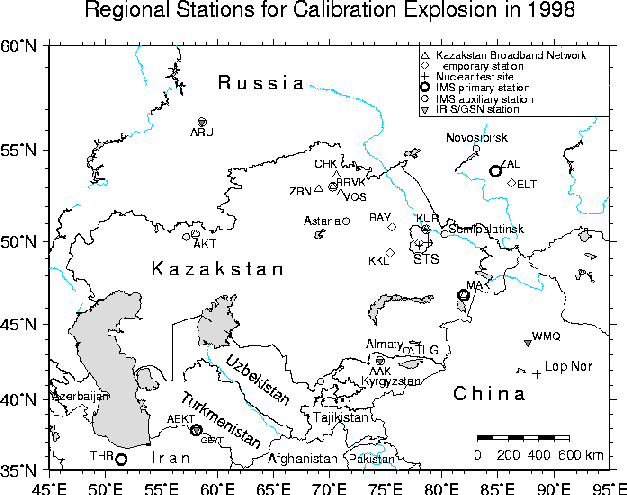
Figure 1: Locations of the broadband stations and an array in Kazakstan. Primary and auxiliary IMS network stations and IRIS/GSN stations in the region are indicated for reference.
Waveform Data Information Product:
Calibration Explosions at Semipalatinsk Test Site, Kazakstan
durifng August and September, 1998
October 1998
Won-Young Kim
Lamont-Doherty Earth Observatory of Columbia University
Palisades, NY 10964, USA
Contributing Institutions:
Institute of Geophysical Research, National Nuclear Center
Semipalatinsk-21, 490021, Republic of Kazakstan
Geophysics and Global Security Division
Lawrence Livermore National Laboratory
Livermore, CA 94550, USA
Earth and Environmental Science
Los Alamos National Laboratory
Los Alamos, NM 87545, USA
Talgar Complex Seismological Expedition
Joint Institute of Physics of the Earth
Talgar 483310, Republic of Kazakstan
Lamont-Doherty Earth Observatory of Columbia University
Palisades, NY 10964, USA
Introduction
During August - September, 1998, two chemical explosions were conducted at the former Soviet Union's Semipalatinsk Nuclear Test Site (STS) in eastern Kazakstan. These explosions were carried out as calibration experiments for the Comprehensive Test Ban Treaty (CTBT) verification as part of the closing of nuclear test tunnels and boreholes at the STS under the Nunn-Lugar Cooperative Threat Reduction Program (see Leith & Kluchko, 1998). The location, origin time and total charge weight of the two calibration explosions are listed in Table 1 and are plotted in Figure 1.
| Date | Origin time | Lat | Long | depth | Charge weight |
| (hh:mm:sec) | (°N) | (°E) | (m) | (ton) | |
| 1998 Aug 22 | 05:00:18.90 | 49.7667 | 77.9908 | 0 | 100 |
| 1998 Sept 17 | 07:19:40.55 | 49.9810 | 78.7559 | 30 | 25 |
Figure 1: Locations of the broadband stations and an array in Kazakstan.
Primary and auxiliary IMS network stations and IRIS/GSN stations in
the region are indicated for reference.
The explosions were prepared by the staff of the Institute of Geophysical Research, National Nuclear Center (NNC), Kazakstan, under the auspices of the Defense Threat Reduction Agency (DTRA), US Department of Defense. Field crew from Los Alamos National Laboratory (LANL) lead by Craig Pearson and NNC deployed seismographs at local ranges (up to about 20 km from the sources) for the experiment, while field crew from Lamont-Doherty Earth Observatory of Columbia University (LDEO) and NNC deployed seismographs at regional ranges - distance from about 100 to 1000 km - for the experiments.
In this waveform data information product, we describe characteristics of the seismographic stations deployed to record regional seismic signals from the calibration explosions and provide basic information on the acquired data to facilitate analysis of the data by researchers.
The regional seismograph deployment for the calibration explosion
was a cooperative effort by several institutions in USA and
in Kazakstan lead by LDEO. The following institutions and individuals
participated in field-works and/or contributed instruments and
financial support.
N. Belyashova, A. Rizvanov, G. Krylov, P. Martysevich, I. Komarov and Z. Sinyova
Institute of Geophysical Research, National Nuclear Center
Semipalatinsk-21, 490021, Republic of Kazakstan
Lewis A. Glenn
Geophysics and Global Security Division
Lawrence Livermore National Laboratory
Livermore, CA 94550
Craig Pearson
Earth and Environmental Science, Los Alamos National Laboratory
Los Alamos, NM 87545
Y. Kopnichev, V. Kunakov, T. Rizvanov, I. Sokolova and N. Emolenko
Talgar Complex Seismological Expedition, Russian Academy of Sciences
Kamo Street 8a, Talgar, Almaty Region 483310, Kazakstan
W. Y. Kim, M. Hagerty, D. Lentrichia and R. McCarty
Lamont-Doherty Earth Observatory of Columbia University
Palisades, NY 10964
Regional Seismographic Station Deployment
To record regional seismic signals from these calibration
explosions, field crews from LDEO and NNC used an existing eight-station
Kazakstan broadband seismographic network and an array in Kurchatov,
Kazakstan (Kim et al., 1996).
The stations used are listed in Table 2 and are shown
in Figure 1.
Two additional temporary stations were also
deployed at Bayanaul (BAY, D=210 km) and at Karkalarinsk
(KKL, D=195 km; see Figure 1) by field
crew from LDEO
and the Talgar Complex Seismological Expedition (Talgar CSE).
The field work for regional seismic data acquisition was supported
by Lawrence Livermore National Laboratory (LLNL), while Los Alamos
National Laboratory (LANL) contributed seismometers
and digital data loggers, as well as microphones for infrasound
measurements.
| Station | Station | Lat | Long | Elev | Sensor | Site |
| name | code | (°N) | (°E) | (m) | model | geology |
| Aktyubinsk | AKT | 50.433 | 58.017 | 400 | CMG-3 | basic rock |
| Bayanaul | BAY | 50.8264 | 75.5537 | 442 | L4C | |
| Borovoye | BRVK | 53.0580 | 70.2828 | 315 | CMG-3 | Granite |
| Chkalovo | CHK | 53.6762 | 70.6152 | 240 | STS-2 | Granite |
| Degelen | DEG | 49.9520 | 77.9945 | 403 | L4C | |
| Yeltsovka | ELT | 53.2614 | 86.2387 | 180 | STS-2 | |
| Karkalarinsk | KKL | 49.3387 | 75.3823 | 925 | L4C | |
| Kurchatov | KUR | 50.7149 | 78.6208 | 240 | STS-2 | Sandstone |
| Makanchi | MAK | 46.8075 | 81.9774 | 600 | STS-2 | Andesite |
| Talgar | TLG | 43.249 | 77.223 | 1120 | CMG-3 | Granite |
| Vostochnoye | VOS | 52.7232 | 70.9797 | 450 | STS-2 | Granite |
| Zerenda | ZRN | 52.9510 | 69.0043 | 420 | STS-2 | Granite |
| Cross-array | KUR21 | 50.622 | 78.531 | 203 | K-213 | Sandstone |
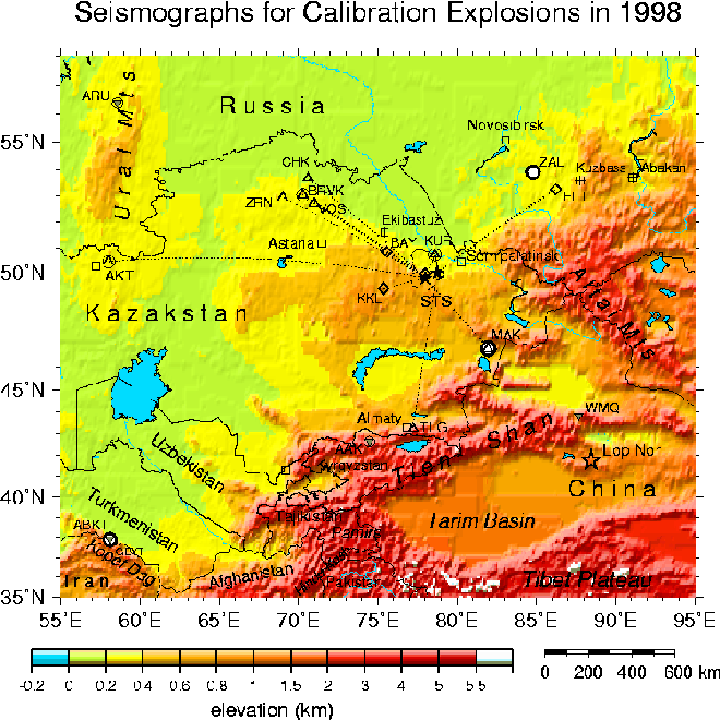
Figure 2: Locations of the broadband & temporary stations deployed
during the calibration explosions of August-September, 1998,
in Kazakstan.
Figure 2 shows regional seismographic stations plotted on a topographic relief map. The source-station paths are indicated by dotted lines. Most of the stations are located on stable continental shield regions which allows fairly good propagation of regional phases such as Pn, Sn, and Lg. To record the two calibration explosions, most of the sites were equipped with a three-component, broadband seismometer and signals were recorded continuously with a nominal sampling rate of 100 samples/sec. Detailed description of the stations and data acquisition is given in Table 3. Station DEG (Degelen) was a temporary deployment for the 100-ton explosion on 08/22/98 and the data logger was re-deployed at ELT (Yeltsovka) in the Altai-Sayan region near Novosibirsk, Russia on August 24, 1998; hence, station ELT recorded only the 25-ton explosion on 09/17/98.
Station TLG (Talgar) failed to record the 100-ton explosion on 08/22/98
due to hard disk error, while station MAK (Makanchi) failed for
the 25-ton explosion on 09/17/98 for the same reason (see Table 3).
We retrieved waveform data from all other stations:
Kurchatov cross-array, KUR, BAY, KKL, MAK, BRVK, CHK, VOS, ZRN and TLG.
Waveform data from AKT is not received at this time.
Instrument Response
Several types of seismometers were used to record the calibration
explosions as listed in Table 4. The short-period seismometer
(L4C, T0 = 1 sec) was used at KKL and DEG for the 100-ton explosion
on 08/22/98. The 21-element Kurchatov cross-array has borehole
short-period, vertical-component seismometers
(K-213, T0 = 2 sec) manufactured during the Soviet era.
The K-213 seismometers were installed in the early 1970's in the
boreholes at various depths with average emplacement depth of about
25 m. The array was refurbished in the late 1980's and again
in January 1995.
The K-213 seismometer has flat amplitude response between 0.5 and 5 Hz
to input ground velocity, however, each element was not individually
calibrated.
| 08/22/98 | 09/17/98 | ||||||
| Station | Station | Sensor | Sample | Recorder | Sensor | Sample | Recorder |
| code | name | model | rate | (A/D bits) | model | rate | (A/D bits) |
| AKT | Aktyubinsk | CMG-3 | 40 | 16 | CMG-3 | 40 | 16 |
| BAY | Bayanaul | CMG-3 | 100 | 24 | CMG-40T | 100 | 24 |
| BRVK | Borovoye | CMG-3 | 40 | 24 | CMG-3 | 100 | 24 |
| CHK | Chkalovo | STS-2 | 100 | 24 | STS-2 | 100 | 24 |
| DEG | Degelen | L4C | 200 | 24 | - | - | - |
| ELT | Yeltsovka | - | - | - | STS-2 | 100 | 24 |
| KKL | Karkalarinsk | L4C | 100 | 24 | CMG-40T | 100 | 24 |
| KUR | Kurchatov | STS-2 | 200 | 24 | STS-2 | 100 | 24 |
| MAK | Makanchi | STS-2 | 100 | 24 | STS-2 | - | - |
| TLG | Talgar | CMG-3 | - | - | CMG-3 | 40 | 16 |
| VOS | Vostochnoye | STS-2 | 100 | 24 | STS-2 | 100 | 24 |
| ZRN | Zerenda | STS-2 | 100 | 24 | STS-2 | 100 | 24 |
| KUR21 | Cross-array | K-213 | 40 | 16 | K-213 | 40 | 16 |
| Sensor | Sensor | Natural period | Sensitivity | passband |
| model | type | (sec) | (V/[M/s]) | (Hz) |
| L4C | short-period | 1 | 166.75 | 1.0-50 |
| K-213 | short-period | 2 | 75000.00 | 0.5-10 |
| CMG-40T | broad-band | 30 | 800.00 | 0.03-50 |
| CMG-3 | broad-band | 30 | 2000.00 | 0.03-50 |
| STS-2 | broad-band | 120 | 1500.00 | 0.008-45 |
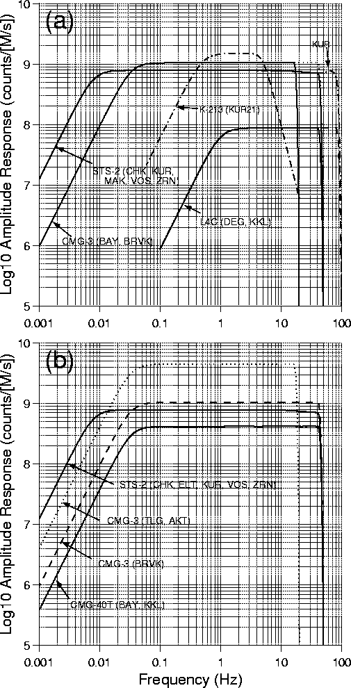
Figure 3: Amplitude responses of seismographs used for calibration
explosions. (a) for 08/22/98, (b) for 09/17/98.
Amplitude responses of various seismometer and data logger
configurations used for the 100-ton explosion on 08/22/98 are
plotted in Figure 3(a).
The gain or digital sensitivity is given in counts/(M/s) and the
signal amplitudes in meters/s can be obtained by dividing the
sample values by this gain.
The amplitude responses of various seismometer and data logger
configurations used for the 25-ton explosion on 09/17/98 are
plotted in Figure 3(b).
Waveform Data
Vertical-component seismic records from the 100-ton calibration explosion on 08/22/98 are shown in Figure 4. The regional signals recorded at stations to the north are plotted with red color, while stations at other azimuths, KKL (D = 194 km, AZ = 257°) and MAK (D = 443 km, AZ = 137°), are plotted with blue color.
Theoretical arrival times of Pn and Sn phases, as well as Pg and Sg (= Lg) phases based on iasp91 model (Kennett & Engdahl, 1991) are indicated by dotted and solid lines, respectively. Other travel time curves appropriate for the region reported in the literature, for example, Nersesov & Rautian (1964) and Gorbunova (1987), may provide better fit to the observed arrival times of various regional phases. The maximum peak amplitude varies from about 97 µ/s at a distance of about 21 km (DEG) to 20 µ/s at about 115 km (KUR), and down to about 0.3 µ/s at about 700 km from source.
Seismic record section of vertical-component records from the 25-ton calibration explosion on 09/17/98 is shown in Figure 5. Notice that at TLG (D=760 km, AZ=189°), P and S waves are very weak, while Lg waves have discernible amplitude. TLG is located at epicentral distance comparable to ZRN (D=754 km, AZ=300°) (Figure 2). A preliminary interpretation is that the Pn and Sn signals which travel primarily through the top of the upper-most mantle were attenuated along the path which crosses Lake Balkash; also the site is noisier than ZRN.
Peak amplitudes observed at four stations in the Borovoye region (BRVK, CHK, VOS and ZRN) from the 25-ton explosion on 09/17/98 ranges from 0.14 to 0.22 µ/s with a small scatter among the stations. Note that waveform data at CHK for 09/17/98 have strong noise, believed to be of electrical origin, at around 1 Hz. Hence, the data have been bandpass filtered with cutoffs at 3 and 10 Hz. At station, KKL, the vertical-component has high-frequency jerks as well as long-period noise. Hence, the data have been bandpass filtered with cutoffs at 0.6 and 20 Hz. ELT has strong local signal arrivals in the time window between Pn and Sn arrivals.
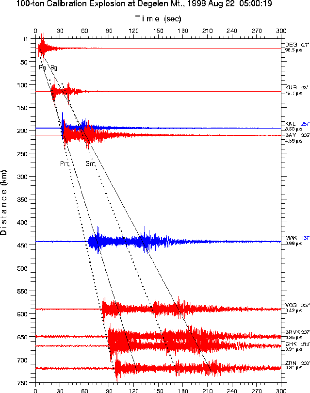
Figure 4: Seismic record section of vertical-component records from
the 100-ton calibration explosion at Degelen Mt. on 08/22/98
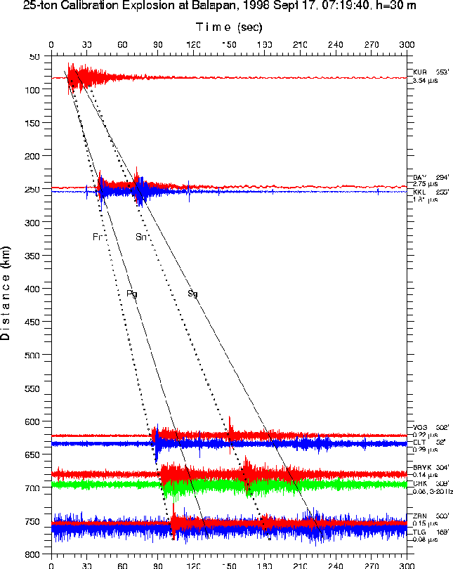
Figure 5: Seismic record section of vertical-component records from
the 25-ton calibration explosion at Balapan on 09/17/98
References
Gorbunova I. V. (1987), Averaged hodograph of the first P-wave arrivals for the region of Central Asia and Kazakhstan, in Earthquakes in the USSR in 1987, Moscow, Nauka Publishing House, 59-63.
Kennett, B. L. N. and R. Engdahl (1991), Traveltimes for global earthquake location and phase identification, Geophys. J. Int., 105, 429-465.
Kim, W. Y., V. V. Kazakov, A. G. Vanchugov and D. W. Simpson (1996), Broadband and array observations at low noise sites in Kazakhstan: Opportunity for seismic monitoring of Comprehensive Test Ban Treaty, in E. Husebye and A. M. Dainty (eds.), Monitoring a Comprehensive Test Ban Treaty, Kluwer Academic Publishers, 462-482.
Leith, W. and L. J. Kluchko (1998), Seismic experiments, nuclear dismantlement go hand in hand in Kazakstan, EOS, Transactions AGU, 79, 437-444.
Nersesov I. L. and T. G. Rautian (1964), The study of dynamics and kinematics of seismic waves at the profile Pamir - Baikal, Proc. 8th Assembly European Seism. Comm., Budapest, 1996, 174-181.