|
|
|---|
Ice Bridge
How Gravity Works
How Gravity Works
Lamont-Doherty Earth Observatory
EXTERNAL LINKS
Using Gravity As a Measurement Tool
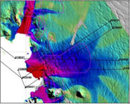
Gravity is the invisible force that pulls matter together. Where there is more mass there will be a stronger gravitational attraction. We often think of gravitational differences on a very large scale, such as between Earth and other planets, with each planet having a constant gravity. However the gravity of the Earth is not homogeneously distributed since different topographic features, such as mountain, plains, valleys or ocean trenches, have different masses. These variations in mass causes a slight variation in gravity. These small variations in gravity due to land features makes gravity a useful tool for measuring and describing areas that are difficult to access or are hidden by water or ice. For example, scientists have used the concept that the gravity field is stronger over submarine volcanoes to map entire regions of the ocean. In the polar areas gravity data is used to map and interpret features hidden by the ice, especially features that relate to volcanoes, faults, water, and even tectonic events. The ICE Bridge project will expand the use of gravity to capture information previously unavailable to scientists, measuring pockets of water hidden beneath the ice.
How will Ice Bridge Gravity Work
Instrument mounted on the DC-8 aircraft flying over the glacier can use lasers to measure the ice surface and radar to penetrate through the ice to measure changes in ice thickness. These measurements will provide information on the overall change in the amount of ice (mass balance), a key piece of information in measuring our changing poles. A missing piece of information, however, is how much water exists underneath the floating ice tongues that form the edges of the glaciers. Warm ocean water heats up the base of the ice sheet, causing an acceleration in the melting and calving of the overlying ice. Knowing the size of these hidden water pockets under the ice is a key piece of information in assessing their impact. Radar can not penetrate through water so previously there has been no way to assess the size of these water cavities using airborne geophysics. However, gravity can be used to fill in this missing piece of information. Since water has less mass than rock it has less gravitational pull. Flying over the glaciers using newly refined high resolution gravity technology scientists can use this difference in gravitational pull to calculate the area underneath the ice tongue. The Sander Geophysics AIRGrav system developed in Ottawa, Canada was successfully used in the 2008/2009 AGAP field season in East Antarctica. This high resolution data can be collected while flying a constant elevation over the landscape in a technique called 'drape flying'. 'Drape flying' in useful for the laser data collection, but poses difficult challenges for traditional gravity systems that must be carefully stabilized due to their sensitivity to movement.
How will the gravity actually work?
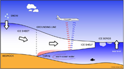
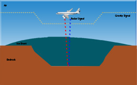 DC-8 flying over a glacier resting on land. As the aircraft flies over the glacier the instruments are collecting multiple pieces of information: Laser will provide surface imaging of the ice; Radar will provide internal imaging of the ice layers down to the underlying bedrock, and can thus be used to calculate ice thickness; Gravity will measure the difference in mass between flying over dense bedrock and a thick glacial ice sheet. The graphic here shows the drop in gravity as the plane moves from flying over bedrock to flying over ice.
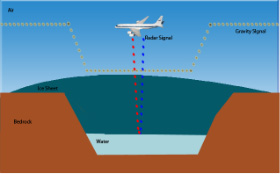 DC-8 flying over a floating glacier. The laser surface imaging data collected flying over a glacier floating on water will be the same whether the subsurface is bedrock or water. The radar will successfully image through the ice layers, but will not penetrate the water beneath the glacier, so the image return will differ from radar collected over bedrock. These images can be used to detect that there is a wet surface under the ice sheet, and to calculate the surface area, but not the depth. This is where the gravity data can be used to collect essential information. Since water has less mass than bedrock, as the plane moves over the floating glacier the gravity will drop with the reduction in mass. This reduction in gravity can be used to calculate the area of underlying water.