next up previous contents
Next: MULTIBEAM Up: MATERIALS AND METHODS Previous: MATERIALS AND METHODS

POSITIONING AND NAVIGATION

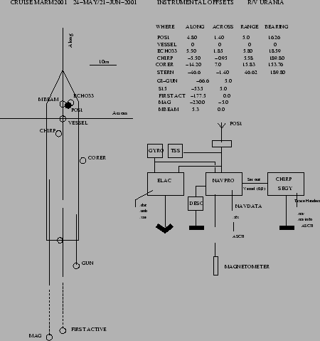
The Positioning system NAVPRO V5.6 by Communication Technology (Cesena, Italy) was used. The instrumental offsets are presented in Fig. 7 and in Tab. 3. The integrated system used a Microtecnica and a Meridian Surveyor SG-BROWN (see below) Gyrocompasses,and a Trimble 4000 Differential Locator, with a DGPS Satellite link by FUGRO. The datum was WGS84 and the Direct Mercator projection on 41 30.00'N was chosen for navigation and display. Timing was set to UTC. The SBP-CHIRP workstation received the 'VESSEL(0,0)' positions by the NAVPRO serial output. These positions were therefore recorded on the SEGY trace headers. The speed of Sound for DEPTH 1 and 2 was set to 1500m/sec, with a transducer immersion of 3.8m.


Table 3: Instrumental Offsets on Ship Urania. Point (VESSEL,(0,0)) is located on the axis of the main mast just behind the Command Bridge. The main GPS antenna (primary positioning system is located on point POS1.
WHERE ALONG ACROSS RANGE BEARING
POS 1 4.80 1.40 5.0 16.26
VESSEL (POS 2) 0 0 0 0
ECHO SOUNDER 33 5.50 1.85 5.80 18.59
CHIRP -5.50 -0.95 5.58 189.80
CORER -14.20 7.0 15.83 153.76
STERN -46.6 -1.40 46.62 189.80
GI-GUN -65.0 5.0    
S15 -53.0 5.0    
FIRST ACTIVE -177.5 0.0    
MAG -230.0 -5.0    
MBEAM 5.30 0    


figure

Figure 7: Instrumental Offsets on R/V Urania
\begin{figure}\centerline{\epsfig{file=PS/UR_OFFSETS.eps,width=10cm}} \end{figure}


next up previous contents
Next: MULTIBEAM Up: MATERIALS AND METHODS Previous: MATERIALS AND METHODS

2001-07-13