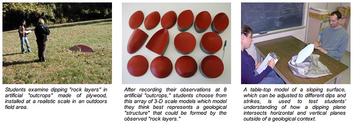
How do students and geologists combine observations from scattered rock outcrops to form a 3-dimensional mental model of a geological structure?
PI's: Kim A. Kastens (Lamont-Doherty Earth Observatory of
Columbia University)
Lynn S. Liben (The Pennsylvania State University, Department of Psychology)
Two questions about learning that are central to, and characteristic of, geoscience education are:
- How do people learn by direct observation of Nature in the field? and
- How do people learn to comprehend, visualize, manipulate, and interpret structures and processes in three dimensions?
This research on learning project addresses both of these tough questions, in the context of field geology learning.
Talks
- What Problems are We Trying to Solve Through the Use of Data, Simulations, and Visualizations in Geoscience Education, and How Research on Learning Can Help (25.6MB). Presented at the Workshop on Teaching with New Geoscience Tools: Visualizations, Models, and Online Data, February 11, 2008, University of Massachusetts, Amherst.
- Cognitive Science Meets Field Geology: How do geologists and students visualize 3-D geological structures from the limited spatial information available in outcrops? (13.9MB). Presented at the Seismology, Geology, and Tectonophysics Seminar, Lamont-Doherty Earth Observatory, October 22, 2007.
- What We've Learned so far about Visualizations in Geoscience Education (1.4 MB). Presented at Gordon Conference On Visualization in Science & Education, July 5, 2007.
Posters
- Spatial Concepts are Critical in Science Education (1.8MB). Lynn S. Liben in collaboration with Kim A. Kastens, Shruti Agrawal, Adam E. Christensen, and Lauren J. Meyers. Presented at NSF, February 19, 2009.
- The Role of Basic Spatial Concepts in Education: What Learners Bring to the Classroom (7.1MB). Lynn S. Liben, Kim A. Kastens, and Adam E. Christensen. Presented at the American Educational Research Association meeting, New York, March 25, 2008.
- Visualizing a 3-D Structure from Outcrop Observations: Strategies Used by Geoscience Experts, Students and Novices (32MB). Kim A. Kastens, Toru Ishikawa, and Lynn S. Liben. Presented at the special session on "Visualization in the Geosciences" at the Geological Society of America annual meeting, Philadelphia, October 24, 2006.
- Students' Difficulty in Visualizing the Horizontal may Contribute to Difficulty on Geological Strike and Dip Tasks (2.7MB) Lynn S. Liben, Kim A. Kastens, and Adam E. Christensen. Presented at the special session on "Visualization in the Geosciences" at the Geological Society of America annual meeting, Philadelphia, October 24, 2006.
Papers
- Kastens, K. A., Agrawal, S., and Liben, L.S. Research Methodologies in Science Education: The Role of Gestures in Geoscience Teaching and Learning. A shortened version of this paper will appear in the March 2008 issue of the Journal of Geoscience Education.
- Kastens, K. A., Liben, L.S., and Agrawal, S. Epistemic Actions in Science Education (6.38MB). Proceedings of Spatial 2008, Basel, Germany.
 This
project was supported by the following grants from the National Science Foundation:
REC04-11823, REC04-11686, GEO03-31212. Any opinions, findings, and conclusions
or recommendations expressed in this material are those of the author(s)
and do not necessarily reflect the views of the National Science Foundation.
This
project was supported by the following grants from the National Science Foundation:
REC04-11823, REC04-11686, GEO03-31212. Any opinions, findings, and conclusions
or recommendations expressed in this material are those of the author(s)
and do not necessarily reflect the views of the National Science Foundation.