Understanding and Improving How People Use Maps
PI's: Kim A. Kastens, Lamont-Doherty Earth Observatory of
Columbia University
Lynn S. Liben, The Pennsylvania State University, Department of Psychology
(research on map skills)
Robert McClintock, Teachers College, Columbia University (development of Where
are We?)
Project Overview
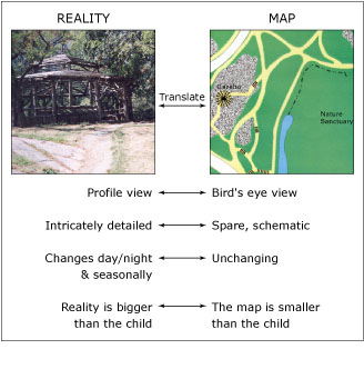
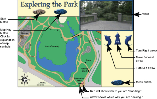
In collaboration with colleagues at Teachers College, Lamont scientists developed the Where Are We? software and associated curriculum materials to help elementary school children learn to "translate" between the visually-perceived world that they sense around them, and the schematic representation of that terrain on a map. This skill, which is essential to a career in field sciences or to effective functioning in today's mobile society, is rarely taught in schools. Where Are We? sets up situations in which students must repeatedly determine correspondences between a map location and the videoed view from that location, as they seek to move to a chosen destination, add new information to the map, or figure out where they are when dropped at an unknown location.
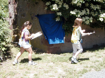
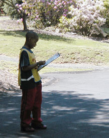
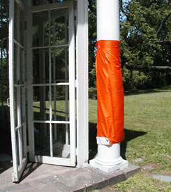
To inform the further development of Where Are We? and to contribute to basic knowledge of human’s use of spatial representations, Lamont and Penn State scientists are documenting and analyzing the nature of misconceptions in map use. We have developed field-based map skills assessments in which participants place colored stickers on a map to indicate where they think a similarly-colored flag is located in the represented space, and place colored markers on the ground to indicate their notion of the location represented by a similarly-colored sticker on the map.
 Our
analysis identifies the following types of misconceptions:
Our
analysis identifies the following types of misconceptions:
- failure to understand the representational or “stand-for” correspondence between symbols on the map and objects in the represented space,
- failure to understand the configurational correspondence among multiple symbols on the map and the analogous objects in the represented space, and
- failure to achieve directional correspondence between map and represented space.
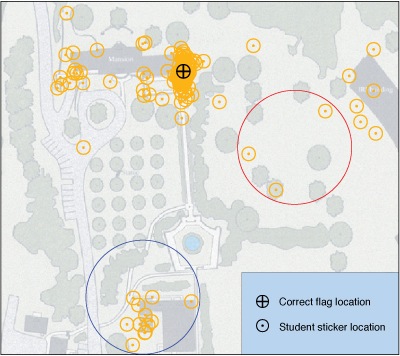
The figure at right displays 4th graders' sticker placements for the orange flag in the Flag Sticker Task. Stickers inside the red circle were placed by students who apparently failed to understand the representational correspondence between the map and the real world, placing their orange sticker on a tree or lawn symbol rather than a building symbol. The blue circle contains stickers from students who showed their understanding of rep- resentational correspondance by placing their orange sticker on a building symbol, but they lacked the understanding of configurational correspondance that would have allowed them to disambiguate among the various buildings on the map.
Maps and Photos of Field Area
Posters and Talks
Posters
- Spatial Concepts are Critical in Science Education (1.8MB). Lynn S. Liben in collaboration with Kim A. Kastens, Shruti Agrawal, Adam E. Christensen, and Lauren J. Meyers. Presented at NSF, February 19, 2009.
- Where Are We? Understanding and Improving how Children Translate from a Map to the Represented Space and Vice Versa" (57.9MB). Kim A. Kastens, Lynn S. Liben. Presented at the Instructional Materials Development PI's Meeting, February 2005.
- Students' Misconceptions About the Correspondences Between a Map and the Terrain Represented by the Map (3.2MB). Kim A. Kastens, Jennifer Griffith, Lynn S. Liben, and Linda Pistolesi. Presented at Fall Meeting of the American Geophysical Union, 2003.
Talks
- Students' Strategies & Mistakes Using a Map in the Real World (19.8MB). Talk given at L-DEO Marine Geology & Geophysics seminar, March 8, 2007.
- Understanding, and Improving, How Children Use Maps (16.2MB). Teachers College, September 19, 2005.
- Spatial Thinking in Geosciences (14MB). CIESIN Spatial Seminar, May 5, 2005.
- Pitfalls [and Possibilities] in the Use of Maps to Visualize Earth Data and Understand Earth Processes (3.7MB). Presented at workshop on Teaching Geoscience with Visualizations: Using Images, Animations, and Models Effectively, Carleton College, February 27, 2004. See also, Kastens' pre-workshop essay (pdf) "My Attempts to Use Maps (and Help Students use Maps) as a Tool for Visualizing, Synthesizing, Capturing and Conveying Information about the Earth."
Papers, Reports, and Instructional Materials
Papers
- Liben, L. S., L. J Meyers and K. A. Kastens (2008). Locating Oneself on a Map: Relation to Person Qualities and Map Characteristics, In Freksa, C., Newcombe, N.S., Gärdenfors, P., & Wölfl, S. (Eds.) Spatial cognition VI: Learning, reasoning, and talking about space (pp. 171-187). Freiburg, Germany: Springer.
- Kastens, K. A., and L. S. Liben (2007) Eliciting self-explanations improves children's performance on a field-based map skills task. Cognition and Instruction. v. 25, pp. 45-74.
- Kastens, K. A. and T. Ishikawa (2006). Spatial Thinking in the Geosciences and Cognitive Sciences. In Earth and Mind., C. Manduca, D. Mogk and N. Stillings, editors, Geological Society of America Special Paper 413, p. 53-76.
- Committee on the Support for Thinking Spatially (2006). Learning to Think Spatially: GIS as a support system in the K-12 curriculum. Washington, DC, National Academy Press.
- Ishikawa, T., Kastens, K., (2005) Why Some Students have Trouble With Maps and Other Spatial Representations, Journal of Geoscience Education, V 53 (2), 184-197.
- Liben, L. S., Kastens, K. A. and Stevenson, L. M., 2002, Real world knowledge through real-world maps: A developmental guide for navigating the educational terrain, Special Issue of Developmental Review, W. M. Williams (ed.) Helping children learn: Developmental consideration sin teaching real-world knowledge, v. 22, pp. 267-322.
- Kastens, K. A., D. Kaplan, and K. Christie-Blick, 2001, Development and evaluation of a technology-supported map-skills curriculum, Where Are We?, Journal of Geoscience Education, v.49, no. 3, p. 249-266.
- Kastens, K., vanEsselstyn, D., & McClintock, R.O. (1996). Where Are We?: An Interactive Multimedia Tool for Helping Students "Translate" from Maps to Reality and Vice Versa, Journal of Geoscience Education, 44, 529-534.
Reports
- Report on Central Park Map Skills Assessment (June 5, 1996)
Instructional Materials
- Where Are We? Teacher's Guide.
- Where Are We? Pedagogical Strategies.
- Why Some Students Have Trouble with Maps and Spatial Representations: An on-line tutorial for geoscience faculty.
 This
work was funded by an Oracle Media Objects Challenge grant and the
following grants from the National Science Foundation: ESI-96-17852 (Kastens
& McClintock), ESI-01-01806 (Kastens), ESI-01-01758 (Liben), and GEO-01-22001
(Kastens). Any opinions, findings, and conclusions or recommendations
expressed in this material are those of the author(s) and do not necessarily
reflect the views of the National Science Foundation.
This
work was funded by an Oracle Media Objects Challenge grant and the
following grants from the National Science Foundation: ESI-96-17852 (Kastens
& McClintock), ESI-01-01806 (Kastens), ESI-01-01758 (Liben), and GEO-01-22001
(Kastens). Any opinions, findings, and conclusions or recommendations
expressed in this material are those of the author(s) and do not necessarily
reflect the views of the National Science Foundation.