|
 |
|
|---|
ICEPOD
An Integrated Ice Imaging System for LC-130s
Science Plan
Lamont-Doherty Earth Observatory
EXTERNAL LINKS
The Science
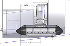
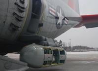
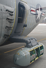 The icePod imaging system works with an instrumented door plug designed to be installed in any of the New York Air National Guard LC-130 rear troop doors. The science instrument system is designed to be modular, allowing scientists to select from a range of ice and surface imaging sensors to support their specific projects. Once filled the 8.5 foot pod will be lowered during flight to collect data on surface and subsurface ice topography of ice sheets, ice streams and outlet glaciers. The original instrument design for the project includes surface elevation, temperature, ice thickness, basal and water ice velocity, and surface snow accumulation.
Instruments being designed and tested include a scanning laser for precise measurements of the ice surface, visible and infrared imaging cameras to document the ice surface structure and temperature and an ice-penetrating radar to recover the ice thickness and constrain the distribution of water at the ice sheet bed. Geo-referencing of the measurements will be provided by precision GPS satellite data integrated with inertial technology. From its 2010 inception, this project has focused on the design, build, calibration, field testing and final commissioning of the instrument over a five-year period. The goal of the icePod project is that the pod measurement system will become a facility operated for the science community and the data will be served to the science community through a supported polar data center.
