Exploring Beneath the Sea Floor
To understand the processes underway inside the Earth, scientists need to get under the ocean and into the sea floor. Sediment layers that build up on the sea floor over millennia hold clues to how shorelines eroded as sea level rose and fell in the past. Deeper down, undersea magma chambers, faults and subduction zones offer insight into how undersea volcanoes and earthquakes behave today – insight that is important to the safety of coastal communities worldwide and for carbon dioxide levels in the atmosphere.
Lamont scientists began new research and published several new discoveries about that behavior in 2015, including the four studies described below. Much of the data was collected aboard the Lamont-operated R/V Marcus G. Langseth, the nation’s premier academic seismic research ship whose capabilities also expanded in 2015 to be able to create higher-resolution images of deeper features than any research vessel in the world.
Mapping Historic Coastlines
The coast of New Jersey was about 90 miles east of today’s beaches during the last ice age. As the ice melted, sea level gradually rose and flooded the coastal terrain, and layers of sediment began to bury the former shoreline. During the summer of 2015, Lamont Adjunct Senior Research Scientist and Alumni Board Chair Greg Mountain led a seismic survey aboard the Langseth that is revealing that ancient coastline, now tens to hundreds of meters beneath the sea floor.
Using seismic waves, Mountain’s team collected data that are being used to build 3D images of the sediment layers that, peeled back, should show how coastal landscapes responded to rising sea levels and hurricanes through history. With a better understanding of how coastal areas changed as oceans rose in the past, communities will be better able to prepare for the damage of storm surge flooding in the future.
The Langseth collects data about the Earth and oceans in several ways, most prominently through a system of hydrophone streamers towed behind the ship that records sound waves bouncing off structures deep beneath the sea floor. Its mapping capabilities increased this year with a new hydrophone streamer system that reaches up to 15 kilometers, allowing the Langseth to capture refracted sound waves and their velocity through sediment layers over a longer distance and wider angle, creating higher-resolution images of deeper features.
“It’s in our best interest to understand what happened in the past because it will help explain what we can expect will happen in the future,” Mountain said. “Sea level along the Jersey shore is likely to be 2.5 to 6 feet higher 100 years from now. With that elevated base, we should expect to see the flooding and destructive equivalent of what now is a once-per-century Superstorm Sandy occur every five to 10 years.”
The New Jersey expedition was a technological leap past prior seismic surveys in this region, designed to improve acoustic resolution of ancient seascapes by collecting data in 3D using an array of 24 hydrophone streamers. Mountain and his colleagues expect that the quality and sheer density of these acoustic “soundings” of ancient terrains below the seafloor will reveal previously unseen details of how the New Jersey coastline has changed over the last 40 million to 60 million years.
Ancient Faults, Seawater & Earthquakes
On the other side of the continent, seismic data from a Langseth cruise is providing new insight into earthquake behavior seaward of the Alaska Peninsula – and likely at other subduction zones around the world.
Rarely a day goes by without earthquakes shaking the Alaska Peninsula, marked by a string of volcanoes curving off the Alaska mainland into the Pacific. Just off shore, two tectonic plates are converging – the Pacific plate is bending under the North American plate and diving deep into the Earth. Along this subduction zone, two adjacent sections that appear almost identical in large-scale characteristics exhibit very different earthquake behavior. One section is highly active with small earthquakes; the other is mostly quiet but for large earthquakes every 50 to 75 years.
Using seismic surveys, Lamont seismologist Donna Shillington and colleagues found a key difference that is providing new clues to earthquake behavior: In certain locations, ancient faults that developed in the sea floor 50 million years ago are becoming active again as the oceanic plate bends, and they are dragging down massive amounts of water, contributing to earthquakes at unexpected depths, a behavior likely happening at other subduction zones, as well.
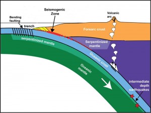
Ancient faults are contributing to earthquakes. Click the image for full size. (Shillington, modified from Oleskevich et al., 1999)
The behavior of the old faults, the scientists found, depends on the angle that the fault trace makes to the subduction zone. Along the highly active Shumagin Gap, near the town of Sand Point, the ancient faults run nearly parallel to the subduction zone. Scientists believe that the rough top of the diving plate, resulting from active faulting as it bends, creates small earthquakes as it slides against the continental plate. They also think that water that percolates into the opened faults contributes to earthquakes and volcanic activity deeper inside the Earth. At the quieter Semidi segment, just to the northeast, the old faults come into the trench at about a 70 degree angle, the sea floor doesn’t shift as much as the plate bends, the surface is smoother as the oceanic plate dives downward, and less water is carried down.
“When we look at subduction zones around the world, we see changes in their earthquake behavior over short distances,” Shillington said. “Our study area is one of the first where we can see this direct correlation between abrupt changes in the faulting and water in the plate and then in the earthquakes in the subduction zone. It’s one explanation for why things can change so dramatically along subduction zones.”
Mapping Magma Chambers
The ancient faults described in Shillington’s study developed 50 million years ago at mid-ocean ridges, where new oceanic crust forms as tectonic plates are slowly pulling apart. The deep magma chambers that generate this new crust remain poorly understood, but a paper published in 2015 is providing some insight into the plumbing.
Images created using seismic surveys from a Langseth cruise to a chain of volcanoes beneath the East Pacific Rise show that magma may be erupting from a multi-layered magma chamber extending two miles or more beneath the seafloor, far deeper than originally thought.
The images may help resolve a debate about how new crust forms at mid-ocean ridges. In one hypothesis, the lower crust is formed as a shallow pool of magma beneath the volcanic spreading center solidifies, forming a kind of crystalline glacier that oozes downward and outward. In another view, pools of magma stacked vertically form new rocks at depths throughout the crust, and send lava to Earth’s surface, creating the upper and lower crust at the same time. The new images seem to support the multi-tier view, predicted by geologists who have studied eroded oceanic crust on land.
“We now see that during an eruption we may have magma moving from one level to another,” said Lamont geophysicist Suzanne Carbotte. In the sub-surface images, Carbotte and former Lamont graduate student Milena Marjanovic recognized multi-layered magma pools, or “melt lenses,” stacked one on top of the other. In addition, these multiple tiers looked as if they had been connected during the eruptions, Carbotte said.
Undersea Eruptions and Climate
Another force may be in play as magma moves to the surface. A new study by Maya Tolstoy suggests that undersea volcanoes flare up on strikingly regular cycles, ranging from two weeks to 100,000 years, and that they erupt almost exclusively during the first six months of each year. The pulses—apparently tied to short- and long-term changes in Earth’s orbit and in sea level—may help trigger natural climate swings.
Some scientists think volcanoes may act in concert with Milankovitch cycles, the repeating changes in the shape of Earth’s solar orbit, and the tilt and direction of its axis, to release more carbon dioxide and produce hot and cold periods. The major one is a 100,000-year cycle in which the planet’s orbit around the Sun changes from more or less an annual circle into an ellipse that annually brings it closer or farther from the Sun. As ice sheets form and sea level drops, that may relieve pressure on submarine volcanoes, which may erupt more.
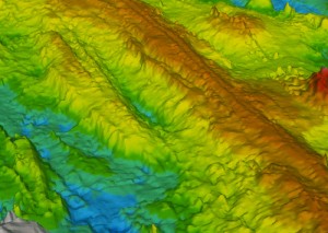
Ridges formed by volcanism near the East Pacific Rise. (Haymon et al., NOAA-OE, WHOI)
Tolstoy has been closely monitoring 10 submarine eruption sites using sensitive new seismic instruments, and she analyzed historic seismic data from ridges in the Pacific, Atlantic and Arctic oceans.
Seismic data suggest that today, undersea volcanoes pulse to life mainly during periods that come every two weeks. That is the schedule upon which the combined gravitational attraction from the Moon and Sun causes ocean tides to reach their lowest points, thus subtly relieving pressure on volcanoes below. Seismic signals interpreted as eruptions followed low tides at eight out of nine study sites. Tolstoy also found that known undersea eruptions were occurring from January through June. January is the month when Earth is closest to the Sun, July when it is farthest—a period similar to the squeezing/unsqueezing effect Tolstoy sees in longer-term cycles. “If you look at the present-day eruptions, volcanoes respond even to much smaller forces than the ones that might drive climate,” she said.
Lamont at Sea: IODP
Out on the oceans, Lamont is a steady presence. Its Office of Marine Operations supports scientists from around the world by operating the Langseth year-round and also by managing scientific support services for U.S. scientists studying the ocean floors through the International Ocean Discovery Program (IODP).
In 2015, Lamont signed a new $35 million, five-year cooperative agreement with the U.S. National Science Foundation (NSF) to manage scientific support services for the IODP, one of Earth science’s longest running international collaborations.
IODP researchers aboard two ships, the JOIDES Resolution and the Chikyu, drill samples of sub-seafloor sediments and rocks and monitor the seabed. Their main study areas are climate, extreme sub-seafloor life, natural hazards such as earthquakes and tsunamis, and the impact of deep processes on the Earth’s surface environment. In recent years, ocean drilling has revealed profound changes in Earth’s past environment and climate, provided context to understand changes now unfolding, and revealed the existence of huge, still largely unknown ecosystems extending nearly a mile below the seabed.
In announcing the IODP agreement, U.S. Rep. Nita Lowey said the agreement “will allow Lamont-Doherty’s scientists to continue advancing our understanding of the natural world around us, and their work will provide the foundation to one day solve some of the globe’s most pressing problems.”