Ice Sheets & Sea Level Rise
Antarctica holds about 27 million cubic kilometers of ice that is constantly flowing, pushed by its own weight. If just part of that ice – the West Antarctic Ice Sheet – were to melt into the ocean, it would raise global sea level by 6 meters. While that loss isn’t imminent, it’s more than a theoretical problem.
“As our planet warms, the polar regions are warming faster than anywhere else on our planet and the ice sheets are changing. They’re melting and they’re sliding faster toward the ocean. Global sea level is going up, and we expect that to go up faster as more of the ice melts,” said Robin Bell, a glaciologist at Columbia University’s Lamont-Doherty Earth Observatory who is leading the Changing Ice, Changing Coastlines Initiative with paleoclimateologist Maureen Raymo.
To understand how a massive ice sheet can become destabilized, we need to understand the structure of the land that holds the ice on Antarctica today.
Bell and her colleagues at Lamont engineered a way to do that in some of the most remote regions on the planet. They took radar and other technology often used on ships to study the sea floor and attached them to a C-130 cargo plane in a capsule called the IcePod.
In 2015, a team of scientists and the Air National Guard began a two-year series of flights with the IcePod over Antarctica’s Ross Ice Shelf to map the terrain hidden beneath.
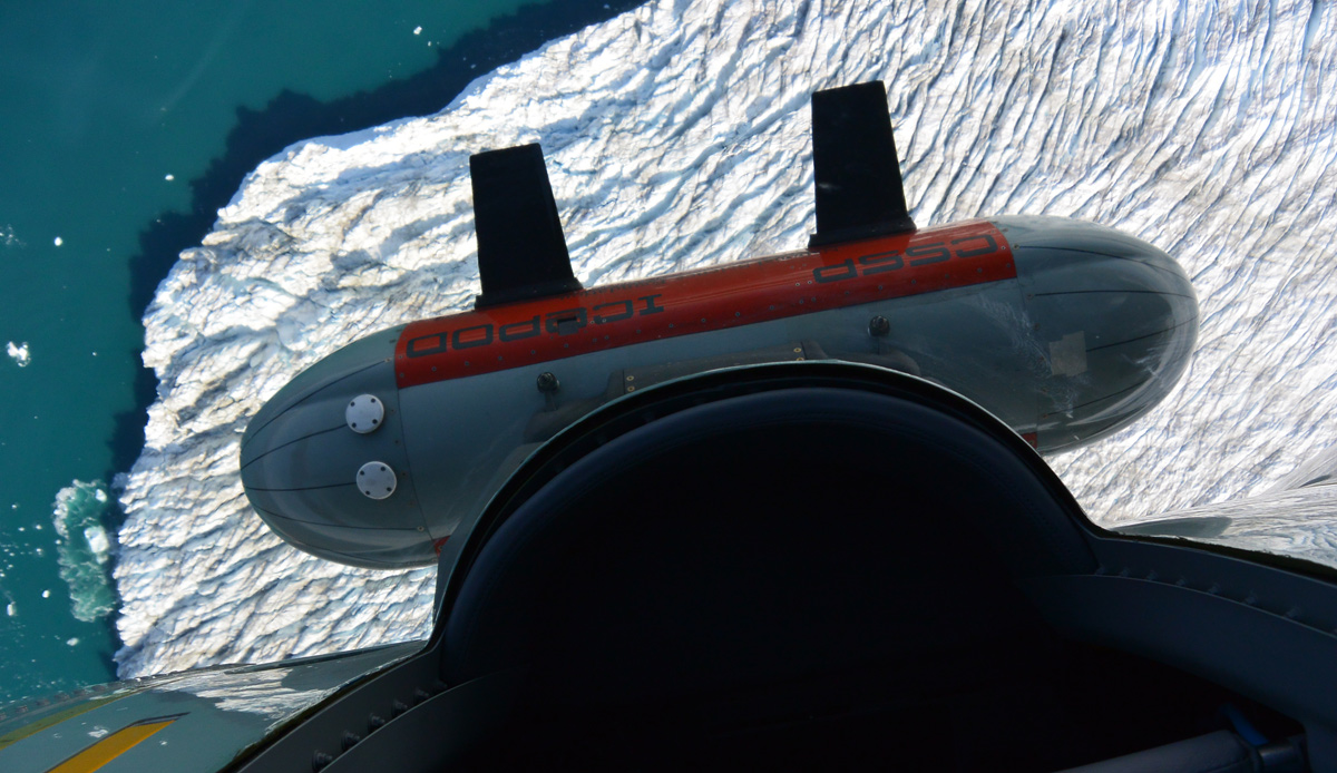
The IcePod, viewed from the door of a C-130 flying over Antarctica.
Mapping the Ross Ice Shelf
Ice shelves are critical to the ice sheet’s stability. They jut out over water ahead of glaciers and slow the glaciers’ flow into the ocean. The Ross Ice Shelf, a massive area of floating ice ranging from about 100 to 900 meters thick and the size of France, covers one of the least known areas of the ocean floor and one of the most important for understanding changing ice on Antarctica.
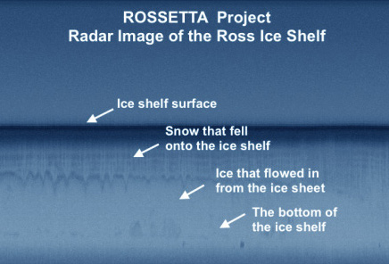
Early data from the IcePod’s first 17 flights across the Ross Ice Shelf are beginning to reveal a picture of the sea floor below the ice shelf in more detail than anything seen before.
The scientists are finding evidence of previously unknown high and low areas, including an area that could turn out to contain deep troughs between the ocean and the grounding line – the point where the ice sheet and ocean meet, said Kirsty Tinto, a Lamont scientist who led the fall expedition of the National Science Foundation-funded survey project, called ROSETTA-Ice.
That texture is being brought into greater focus by gravity measurements, using the team’s new Moore Foundation gravimeter, along the flight lines that are about 10 kilometers apart. The result will be a far higher resolution than current maps, which have a 55 km resolution – that’s one data point to describe an area about the size of Yosemite National Park, Tinto said.
The IcePod also carries deep and shallow ice radar systems that are revealing the structure within the ice sheet itself. The scientists expect to be able to look back at almost 1,000 years of changes within the ice shelf and see how the ice flows outward from the continent, how snow builds up, and whether the ice is melting from below.
“The data are already changing our understanding of the formation of the Antarctic continent and its role in shaping the ways that the ice sheets there will change over the next 20-30 years,” said Nick Frearson, lead engineer on the IcePod project.
The team is processing nearly 50 terabytes of data from the first half of the expedition and expects to have preliminary analyses as early as this fall. It is data-intensive work, with 2-8 terabytes coming in per flight and greater data capacity needed. In 2016, they plan to return to Antarctica for 19 more flights for a total of 60,000 kilometers of survey lines. They’re also raising funds to bring along innovative, floating remote sensing devices that would be dropped along the edge of the ice sheet to collect and send back data about currents, temperature and salinity.
“We’re going to uncover a ton of questions from this survey,” Tinto said. “There is still a lot that we don’t know about Antarctica.”
Forecasting Sea Level Rise
At Lamont, scientists are also working on the many complex questions surrounding sea level rise, often leading to two critical questions: how much will sea level rise and how fast. The answers matter to lives and coastal economies around the world.
Raymo, who is also director of the Core Repository at Lamont, is using sediment cores to understand how sea level rose during past periods that were as warm or warmer than today. Using GPS and other instruments, she and her colleagues have been measuring evidence of past sea level highs around the world and installing instruments along coastlines to measure modern hydrodynamic processes.
Their work is also contributing to risk analysis for storm surges and tidal heights by looking at natural storm barriers and how coral reefs absorb and dissipate energy from waves and whether they can keep pace with rising sea level.
“Lamont is a unique place to address the changing ice and changing coastlines because of Lamont’s long-term holistic view of the problem,” Bell said. “We’re bringing together the past, the present, and the future so we can really understand how the system works and provide the best insight into what’s going to change in the future.”
During the summer of 2015, the National Academy of Sciences, in a report co-chaired by Bell, declared West Antarctica a research priority and recommended that the U.S. Antarctic Program at the National Science Foundation make changing ice sheets and sea level rise a top research goal for the next 10 years.