|
 |
|
|---|
ICEPOD
An Integrated Ice Imaging System for LC-130s
Home
Lamont-Doherty Earth Observatory
EXTERNAL LINKS
Summary
Scientists have observed that the polar ice sheets and glaciers are changing more rapidly than anticipated and have been seeking new ways to collect the data they need to understand these changes and the processes that are driving them. Using satellites to measure ice from space is an efficient way to collect information on the vast polar regions, yet while satellites can provide measurements on the changes...the thinning and acceleration of ice, and the overall loss of ice mass...they are unable to provide the observations we need to understand 'why' these changes are occurring. In order to better understand the 'why' we need to collect regular coincident (occurring at the same space and time) measurements on the ice surface and the ice bed. Currently this can not be done by satellite so other techniques are being used. Flying over the ice sheet using newly refined instruments is a technique that has been successfully deployed in several recent projects (AGAP, ICEBridge), however, the cost and resources needed for this type of work limits this type of data collection. The Lamont IcePod project builds from these successful projects to develop a mechanism for widespread data collection through using existing equipment (LC 130 aircraft) and an existing program (New York Air National Guard 'NYANG' routine support flights) to fill this need.
Project Goal
 |
|---|
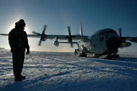
photo credit NYANG |
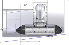
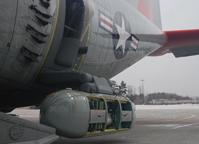
IcePod focuses on the development of an integrated ice imaging system that can measure in detail both the ice surface and the ice bed. The system will be enclosed in a Common Science Support Pod (CSSP) mounted on the rear troop door of the LC-130 transport aircraft flown by the NYANG 109th Airlift Wing. The instruments can collect an array of measurements during routine and targeted missions across Antarctica and Greenland. With the ability to regularly collect concurrent data on the change in ice volume and the underlying processes, IcePod will allow us to examine not just 'how fast' the ice sheets are changing but 'why'. The fundamental data sets produced by the icePod system are essential to support the development of accurate ice sheet models necessary for understanding and predicting changes such as future climate and accompanying sea level.
The baseline of critical data collected through this project will be shared through a community research facility, providing data to scientists and educators globally. This project will design, build, calibrate, test and commission the instrument over a five-year period. The goal of the icePod instrumentation is that the sensor system will become a facility operated for the science community and the data will be served to the science community through a supported polar data center.
Funding for this project came through special Recovery Act Funding of a National Science Foundation Major Research Instrumentation grant.
